Heavy Rain After the Storm
3 August 2026
CHONG Sze-ning
Earlier this month (July 2026), Tropical Cyclone Maysak lingered over Guangxi for an extended period, bringing sustained heavy rainfall and flooding1. Even after its main body moved out of Guangxi, the circulation of its remnant, combined with an active monsoon trough, continued to produce precipitation through the "train effect"2. It is still fresh in memory that in July 2021, under the influence of the easterly airstream at the periphery of Tropical Cyclone In-Fa and to the southern flank of the subtropical ridge3, compounded by other factors, Zhengzhou in Henan Province of China suffered from severe flooding triggered by record-breaking rainstorms. Besides heavy rain brought by a tropical cyclone passing through or skirting in close proximity, its impact must not be overlooked even when it is departing.
When low-pressure systems (such as remnants of tropical cyclones) move across the inland area of southern China, the airstream to its south can bring heavy rain to coastal areas. The duration of precipitation and affected areas depend on multiple factors, such as the position, circulation and intensity of the low-pressure system, whether the airstream is accompanied by sufficient moisture advection, horizontal wind speed convergence at different locations caused by coastal terrain, the existence of a ridge of high pressure to its east reinforcing the convergence of airstreams, and upper-level divergence, among others. These complex conditions increase the challenge in forecasting. Examples of heavy rain brought to coastal regions when previous tropical cyclone or remnant crossed the inland area of southern China are illustrated in the following paragraphs. Radar imagery shows that such rainfall typically appears in linear patterns along coastal areas, but the locations can be vastly different. Let's look at some past cases of heavy rain that followed after the passage of tropical cyclones.
The most memorable example among them is Haikui in September 2023. After making landfall to the east of Hong Kong, its remnant moved westward along the coast of southern China (the red arrow in Fig. 1 (Top) indicates its direction of movement). Under the influence of a trough of low pressure associated with the remnant of Haikui along the coast of Guangdong, continuous torrential rain affected Hong Kong. The Observatory had to issue the Black Rainstorm Warning on 7 September till 8 September.
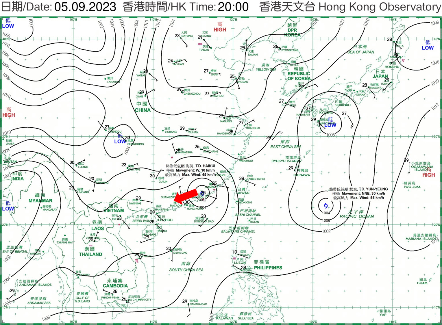
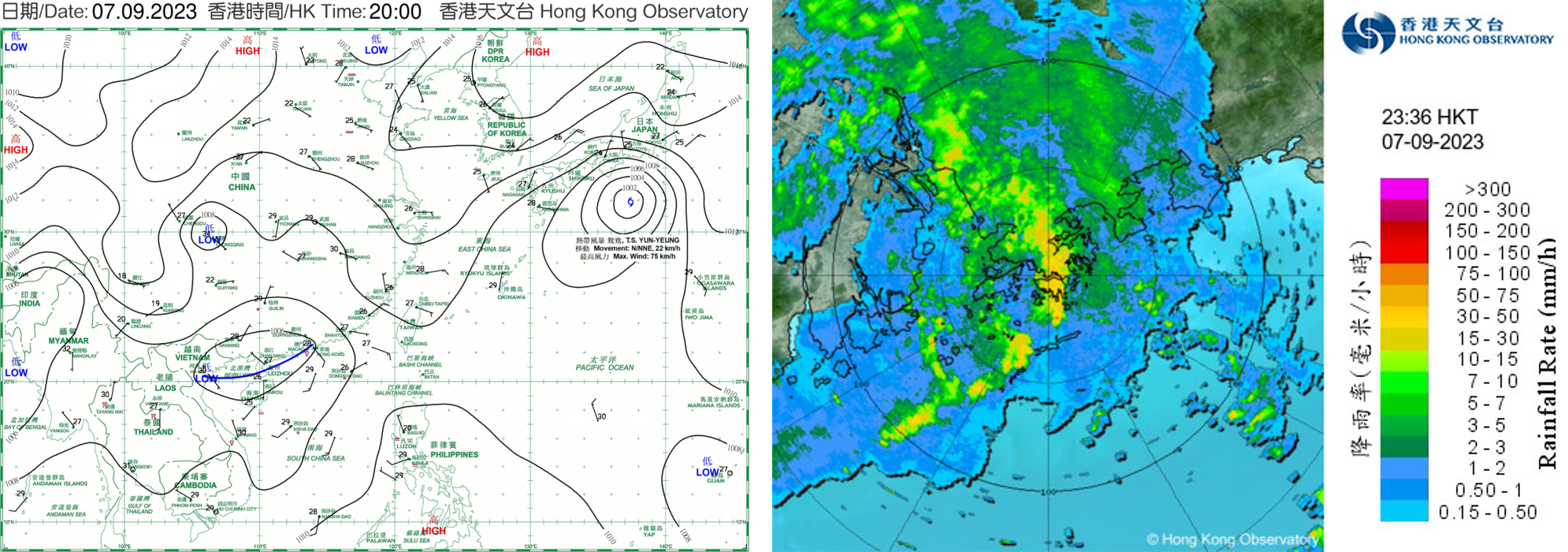
Figure 1. (Top) Weather chart at 8 p.m. on 5 September 2023. (Bottom) Weather chart at 8 p.m. and radar imagery at 11:30 p.m. on 7 September.
Danas last year (2025) was another example: after making landfall east of Hong Kong, it moved westwards and brought us heavy rain (Fig. 2 (Top)). Driven by the remnant of Danas and the active southwest monsoon, rainfall was especially intense on the night of 9 July and on 10 July, with over 100 mm recorded widely across Hong Kong and over 200 mm in Tsuen Wan and Tsing Yi. Red Rainstorm Warning was issued three times during the period. On 11 July, although the remnant of Danas still lingered near the Pearl River Estuary (Fig. 2 (Bottom)), it did not bring heavy rain over Hong Kong.

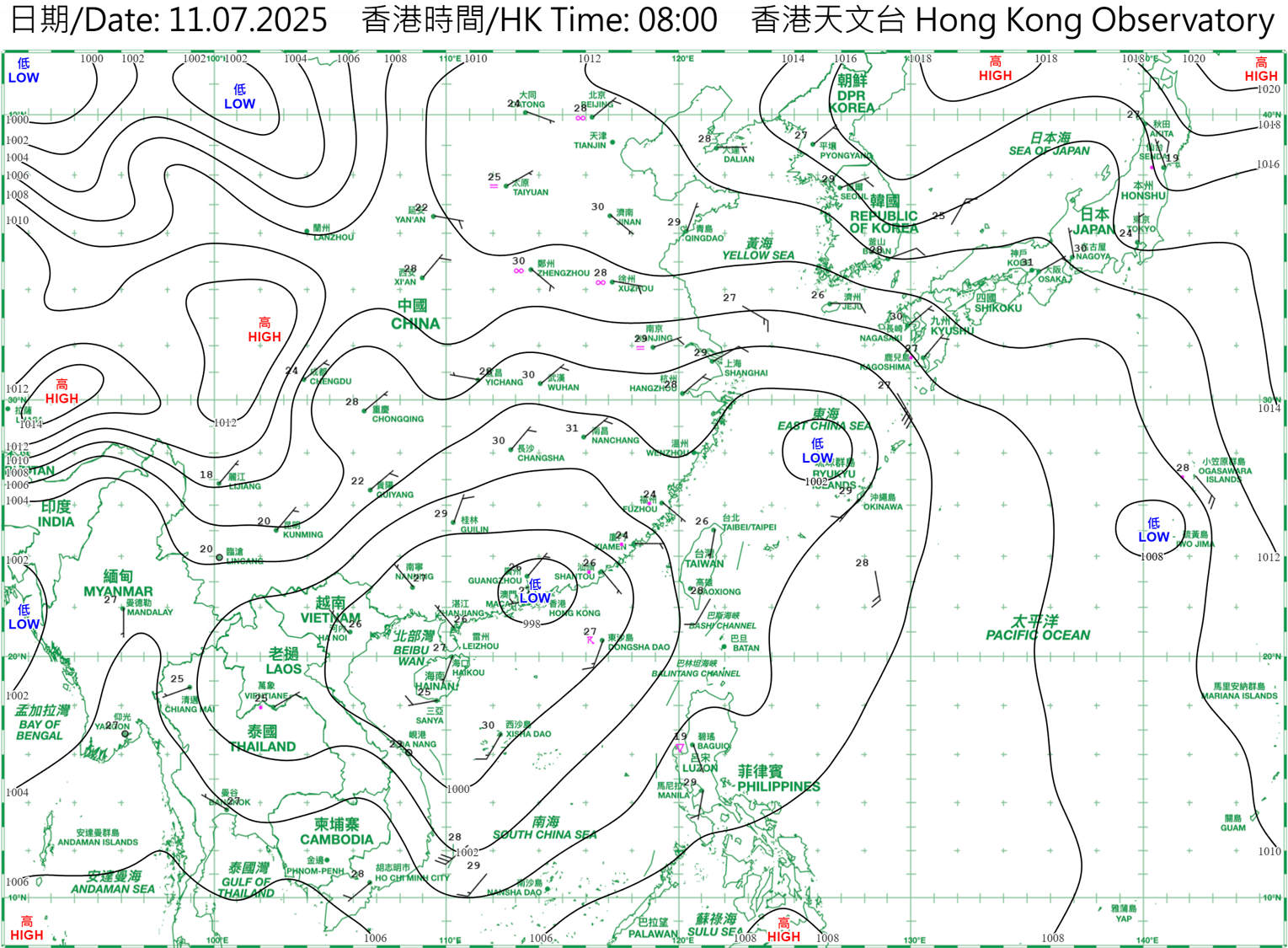
Figure 2. (Top) Weather chart at 8 p.m. and radar imagery at 11:30 p.m. on 9 July 2025. (Bottom) Weather chart at 8 a.m. on 11 July.
In the two examples above, the vortices passed relatively close to the Pearl River Estuary. In contrast, Bailu in 2019 is a case where the vortex was much farther away: on 26 August of that year, the remnant of Bailu crossed the northern part of southern China in the early hours (red arrow in Fig. 3 shows the direction of movement), relatively farther away from the coast. The associated rainbands brought heavy rain and squally thunderstorms to Hong Kong, necessitating the Observatory to issue the Red Rainstorm Warning.
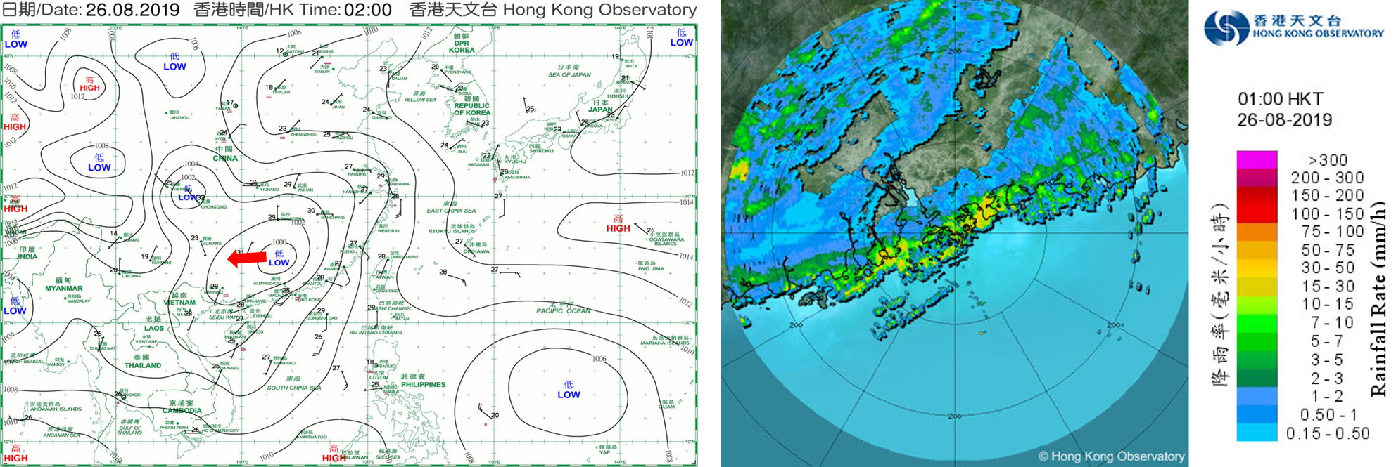
Figure 3. Weather chart at 2 a.m. and radar imagery at 1 a.m. on 26 August 2019.
On 14 August 2025, Tropical Cyclone Podul crossed the inland area of southern China in the morning. Radar imagery showed a significant convergence band over Hong Kong at that time (Fig. 4). Black Rainstorm Warning was issued on the day by the Observatory, but less rainfall affected west of the Pearl River Estuary.

Figure 4. Weather chart and radar imagery at 8 a.m. on 14 August 2025.
On 26 July 2026, Sunday, Tropical Cyclone Noul skirted past to the northeast of Hong Kong, necessitating the issuance of the Increasing Gale or Storm Signal, No.9 by the Hong Kong Observatory. Although Noul weakened and gradually moved away from Hong Kong on 27 July, Monday, the threat of heavy rain to the vicinity of the Pearl River Estuary remained unresolved. From Fig. 5, areas of intense thundery showers persistently developed to the west of the Pearl River Estuary starting from around 3 a.m. on Monday, exhibiting the “train effect”: while the rain areas moved eastwards, convection continuously developed at its western end, causing prolonged rainfall to affect the same region. Under such circumstances, cumulative rainfall in affected regions is higher. At that time, hourly rainfall exceeding 50 millimeters was recorded over many places in Zhuhai and Zhongshan; hourly rainfall even exceeded 100 millimeters in certain places, with 4-hourly rainfall of approximately 160 millimeters. Fortunately, the band of intense thundery showers weakened while crossing the Pearl River Estuary, so Hong Kong was not significantly affected.
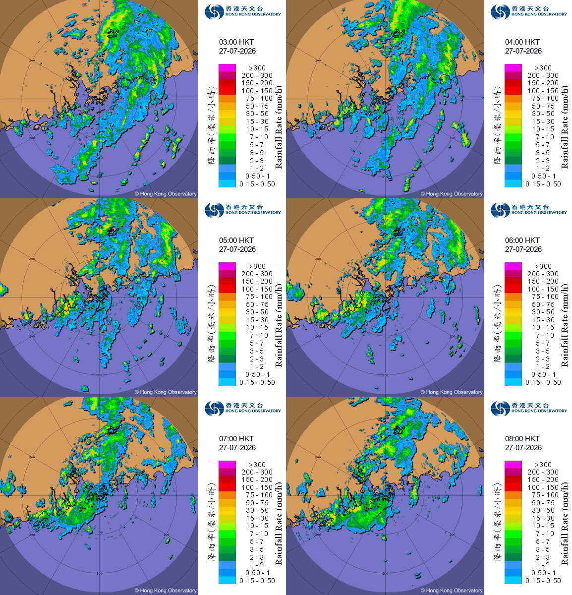
Figure 5. Radar imagery animation from 3 a.m. to 8 a.m. on 27 July 2026.
In fact, after the passage of tropical cyclone, streets throughout Hong Kong are often littered with a lot of dead leaves, branches, gravels or debris flurried to the ground and be washed down to different locations, resulting in potential blockage to the entrances of drainage systems at such locations4, and increasing flood risk.
As the limited examples above show, even for the same type of driving system, i.e., tropical cyclone or its remnant, assessing the rainfall it will bring to Hong Kong depends on many factors, making the forecast more challenging. Development of rainstorm is largely stochastic. Rainstorm can evolve very rapidly and span only ten to a few tens of kilometres in extent. Predicting rainstorms therefore remains a major challenge in meteorology today. In any case, the Observatory will provide early alerts to the public as early as feasible, hoping to enable all parties to respond promptly.
1 (Chinese only) 廣西洪災已致37.5萬人受災 超百條河流現超警洪水
https://www.hkcd.com.hk/hkcdweb/content/2026/07/07/content_8763673.html
2 (Chinese only) 風力10級卻刷新多地降雨極值 專家解析「美莎克」重創廣西成因
https://www.wenweipo.com/a/202607/08/AP6a4dbc39e4b0b49ad1c27406.html
3 (Chinese only) 中央氣象台、河南省氣象台聯合解析河南特强級暴雨:「前所未見」的河南暴雨是「千年一遇」嗎?
https://news.sciencenet.cn/htmlnews/2021/7/461758.shtm
4 Beware of Multi-Hazard Combined Effect
https://www.hko.gov.hk/en/education/tropical-cyclone/weather-effects-and-impact/00674-Beware-of-Multi-Hazard-Combined-Effect.html