Beware of Multi-Hazard Combined Effect
Beware of Multi-Hazard Combined Effect
YEUNG Hon-yin and CHONG Sze-ning
May 2022
When natural hazard such as high winds or heavy rain occurs individually, well-designed urban infrastructure can normally withstand the associated disasters with tolerable impacts being expected on the society. However, the concurrence of multiple hazards can lead to superposition of their effects, resulting in exacerbated disasters that may exceed the resilience limits of the urban infrastructure. The longer the combined effect lasts, the higher the risks and the greater the societal impacts potentially.
Without multi-hazard combined effect, flooding may occur only at some low-lying areas or spots with poor drainage in Hong Kong even if a rain episode is intense enough to warrant the Amber Rainstorm Warning signal. In contrast, another rain episode with similar rainfall intensity can pose rather different flood risk in the presence of a tropical cyclone (TC). The more persistent the rain is, the higher the cumulative flood risk. Imagine that the Strong Wind Signal, No.3 has been in force with strong winds generally blowing over Hong Kong (even occasional gales over some areas) for some time. A lot of dead leaves, branches, gravels or debris may have flurried to the ground and be washed down to different locations, resulting in potential blockage to the entrances of drainage systems at such locations. Moreover, as the storm approaches, the sea level may rise significantly above the normal position due to storm surge and/or pounding waves, resulting in potential seawater intrusion and flooding over relatively low-lying areas along the coast (Figure 1). This example illustrates how the impact on flooding due to the combined effect of TC and prolonged rainstorm can be way more severe than the totality of impacts from the two hazards occurring individually.
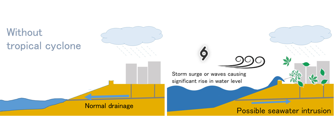
Figure 1 Similar rainstorm situations with (right) and without TC (left). Effects from TC-induced high winds, storm surge, pounding waves, etc., can add up and degrade drainage.
Whenever inclement weather events are expected to superimpose, you may need to start preparations earlier and adopt multiple precautionary measures as appropriate. Pay attention to outdoor conditions, in particular whether there is traffic disruption or not, and reserve sufficient time plus safety margin for your trip before you start. To allow early protective measures by members of the public, the Observatory will promulgate on any significant wind-rain combined effect, be it actual or forecast.