Ten Questions and Answers about Earthquake and Tsunami arising from the Hualian Earthquake on 3 April 2024
11 April 2024
Queenie CC Lam, Wilson WS Chan and David TW Hui
A major earthquake with magnitude 7.3 and a focal depth of about 10 km occurred in Taiwan at 7:58 a.m. on 3 April 2024 based on the analysis of the Hong Kong Observatory (HKO) [1]. The epicentre was near the coast of eastern Taiwan, about 15 km south-southeast of Hualian. Although it is about 790 km away from Hong Kong, more than a hundred people in Hong Kong reported felt earth tremor. A local intensity of III (Three) on the Modified Mercalli Intensity Scale was rated based on a combination of instrument and the observations and sensations of people in the local earth tremor reports.
The earthquake killed more than 10 people and injured more than 1000 in Taiwan [2]. It also left at least a few tens missing. Some buildings titled and massive landslides were triggered. It was the strongest earthquake hit Taiwan since the 1999 Chi-chi earthquake with magnitude 7.7. A maximum intensity of 6+ on the scale adopted by the Central Weather Administration (CWA) [3] was recorded in Hualian. The earthquake was felt in some parts of the coastal region of China including Hong Kong. Continued aftershocks of more than 50 times occurred after the mainshock with one of them reaching a magnitude of 6.4 occurred 13 minutes after the mainshock, while most of them were between M4.0 to 5.0.
Tsunami waves were triggered by the Hualian earthquake. The Observatory issued Tsunami Information Bulletin at 11:10 a.m. on 3 April with a forecast of at most around 0.1 metre reaching Hong Kong between noon and 1 p.m. that day, and the impact to Hong Kong was expected to be small. A media briefing was also conducted to disseminate the earthquake and tsunami information to the public.
1. What are the causes of earthquakes in general, and the one in Hualian?
An earthquake is a complex series of ground vibrations caused by the release of stored energy in the ground, usually during a sudden, unpredictable movement along a geological fault. Movements of a fault or a tectonic plate will be resisted by friction and earthquakes will only occur when the shear stress across it has built up to a level at which it exceeds the frictional resistance. Other natural processes, such as the movement of magma beneath volcanoes or the Earth's crust, can generate earthquakes. Earthquakes can also result from human activities, most obviously in relation to controlled or accidental large explosions and man-made changes such as the filling of newly constructed large reservoirs.
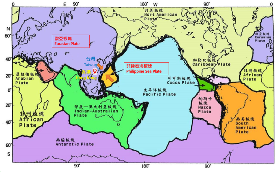
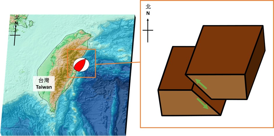
Taiwan is located within a complex zone of convergence at the boundary between the Philippine Sea Plate and the Eurasian Plate (Figure 1), which belongs to an active seismic belt. The Philippine Sea Plate is moving northwest and subducting below the Eurasian Plate near Hualian. The two plates collide at a speed of about 7 to 8 centimetres per year [4]. According to the US Geological Survey (USGS) [5], the Hualian earthquake occurred as the result of reverse faulting (Figure 2) likely associated with faulting within the Eurasian Plate.
2. Why the analysed earthquake parameters were slightly different among different official centres? It was also noticed that the magnitude could be amended at a later time of reporting. Why is that so?
As different seismological monitoring centres receive and analyse data at different times from a set of different seismograph stations including those from their local network and the global network, their computed magnitudes may have slight differences. The Hong Kong Seismograph Network contains two broadband seismograph stations, seven short period seismograph stations and five strong motion accelerographs. The Hong Kong Po Shan Seismological Station also contributes real-time data to the Global Seismograph Network.
Different centres adopt different types of earthquake magnitude [7] or a weighted average of different types of magnitude in their earthquake reports. For stronger earthquakes, seismic waves spread farther away from the hypocentre and data from a larger number of seismograph stations can be made available for a more accurate analysis of the earthquake magnitude. Therefore, the magnitude of a stronger earthquake is often subject to amendments upon the reception of data from seismograph stations farther away from the epicentre and recalculation.
3. What are the scales to quantify the intensity of an earthquake?
The earthquake intensity is the measure of shaking at a certain location. It is mostly related to both the magnitude of the earthquake and the distance of that location from the hypocentre. The type of surface geology and the direction of the earthquake ruptured will also affect the intensity.
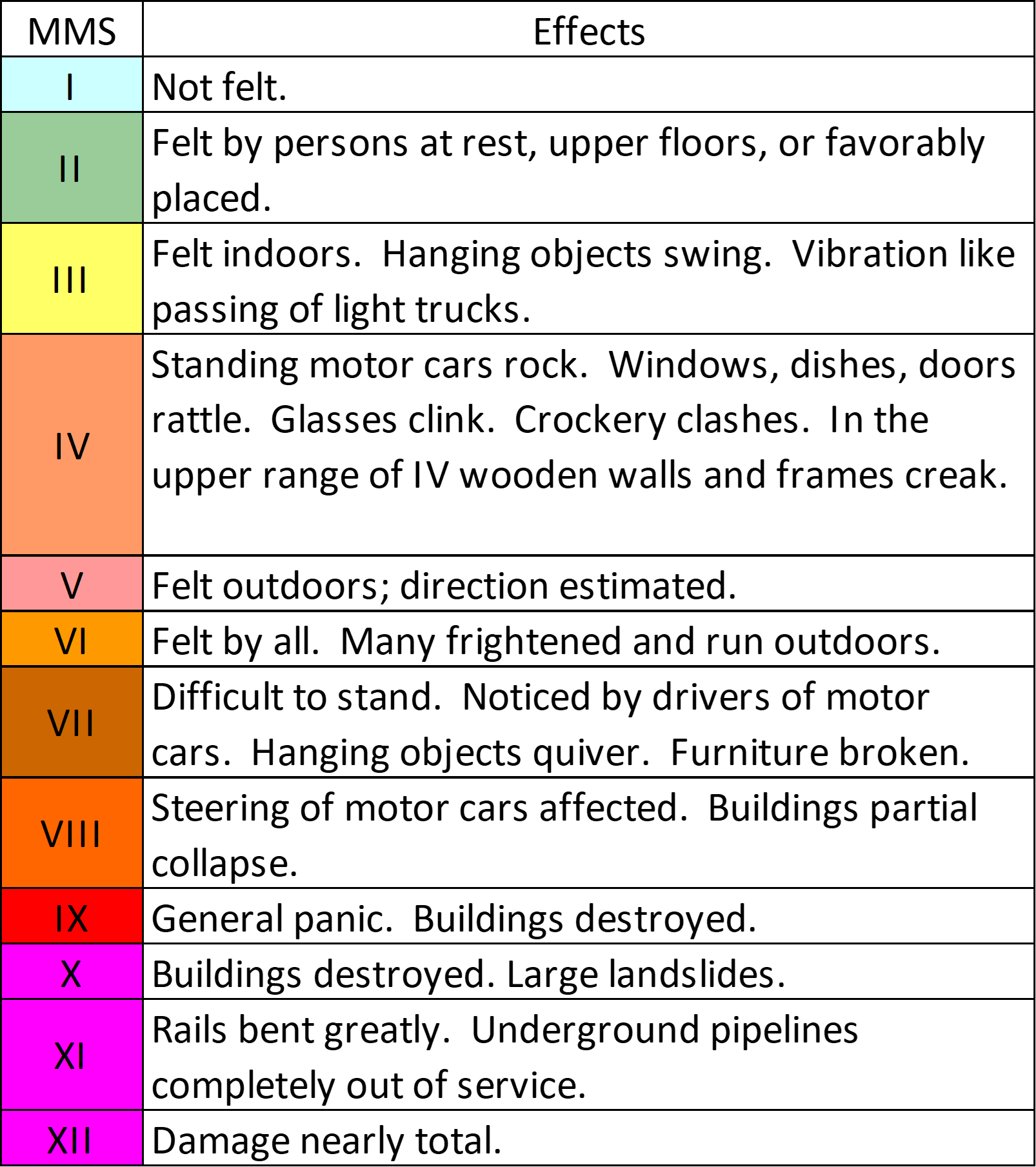
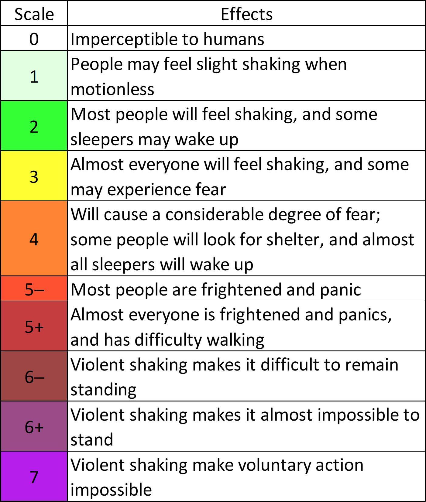
Different countries or regions in the world adopt a certain earthquake intensity scale to quantify the tremor at different locations. In Hong Kong, the Modified Mercalli Scale (MMS) [8] is adopted. The MMS is scaled into 12 different levels, which are determined from the feel of tremor by human beings as well as the effects and severity of damages on building structures, etc. (Figure 3). The earthquake intensity scale adopted by Taiwan is shown in Figure 4.
An instrumental based method to measure peak ground acceleration (PGA) or peak ground velocity (PGV) can be used to indicate the amount of ground shaking. The Hong Kong Observatory makes use of strong motion accelerograph to determine PGA, which indicates the maximum acceleration experienced by a small object on the ground or the highest rate of change of speed that the ground undergoes as seismic waves pass through. By correlating the intensity determined by human observations or sensations during an earthquake with the PGA values at a certain place for a period of time with a sufficient number of events, an objective way of determining earthquake intensity based on instrument readings can be achieved. PGA is typically quantified in terms of the acceleration in units of gravity (g) or expressed in units of gal (cm/s2). PGA serves as an important parameter for assessing earthquake hazards.
4. How to monitor earthquakes and are they predictable?
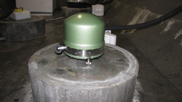
We set up seismograph station and utilise seismometers (Figure 5) to detect the seismic waves generated by earthquakes (Figure 6). Parameters such as the origin time, epicenter, magnitude and focal depth of the earthquake can then be computed using the data collected from a network of seismograph stations. However, there is no reliable way yet to predict earthquakes even with the current state-of-the-art scientific knowledge and technology.
5. What are the threats associated with an earthquake and the precautionary measures?
The main threats of earthquakes include the collapse of buildings, landslides, breakdown of electricity supplying systems, fire hazards caused by the leakage of gaseous fuels, etc. Strong submarine earthquakes may trigger tsunamis, posing severe threats to coastal residents. When a strong earthquake occurs, the first thing is to keep calm and then seek refuge as appropriate. A infographic of safety rules during strong earthquakes is given in Figure 7 for a quick reference. Details can be found in [9].

6. What are the causes of tsunami in general, and the one associated with Hualian earthquake?
A tsunami is a series of waves caused by a rapid and dramatic disturbance in the ocean, typically triggered by underwater earthquakes, massive landslides, volcanic eruptions, or the impact of celestial bodies. Depending on the disturbance, the water can be a dip (trough) followed by a crest or the other way around when the waves propagates away from the origin. A dip or trough of tsunami wave will cause water to recede or water level drop abnormally and then followed by a wave crest or water level increase.
The speed and characteristic of a tsunami wave are influenced by factors such as the water depth, bathymetry (underwater topography), and coastal features it encounters as it travels.
In the case of Hualian earthquake, the intense and shallow undersea earthquake with magnitude 7.3 and a focal depth of about 10 km caused the sudden and abrupt vertical displacement of the ocean floor, generating significant disturbance in the ocean. Tsunami waves were generated and they travelled to regions as far as a few hundred kilometres away from the epicentre.
7. How to predict tsunami?
Computer simulation models are often utilised to predict tsunami wave heights and the expected time of arrivals at different locations for tsunamis triggered by undersea earthquakes after analysing the seismic parameters of the earthquake event including earthquake occurrence time, epicentre, magnitude, focal depth, focal mechanism.
Tsunami waves can be monitored using instruments like tide gauges and Deep-ocean Assessment and Reporting of Tsunamis (DART) systems. By monitoring any abnormalities in the sea level changes, tsunami wave height can be analysed by applying a filter to the time series of the sea level data. A crude estimation of tsunami wave height in downstream areas can be inferred from the nearest tsunami wave observation by using a correlation and scaling method.
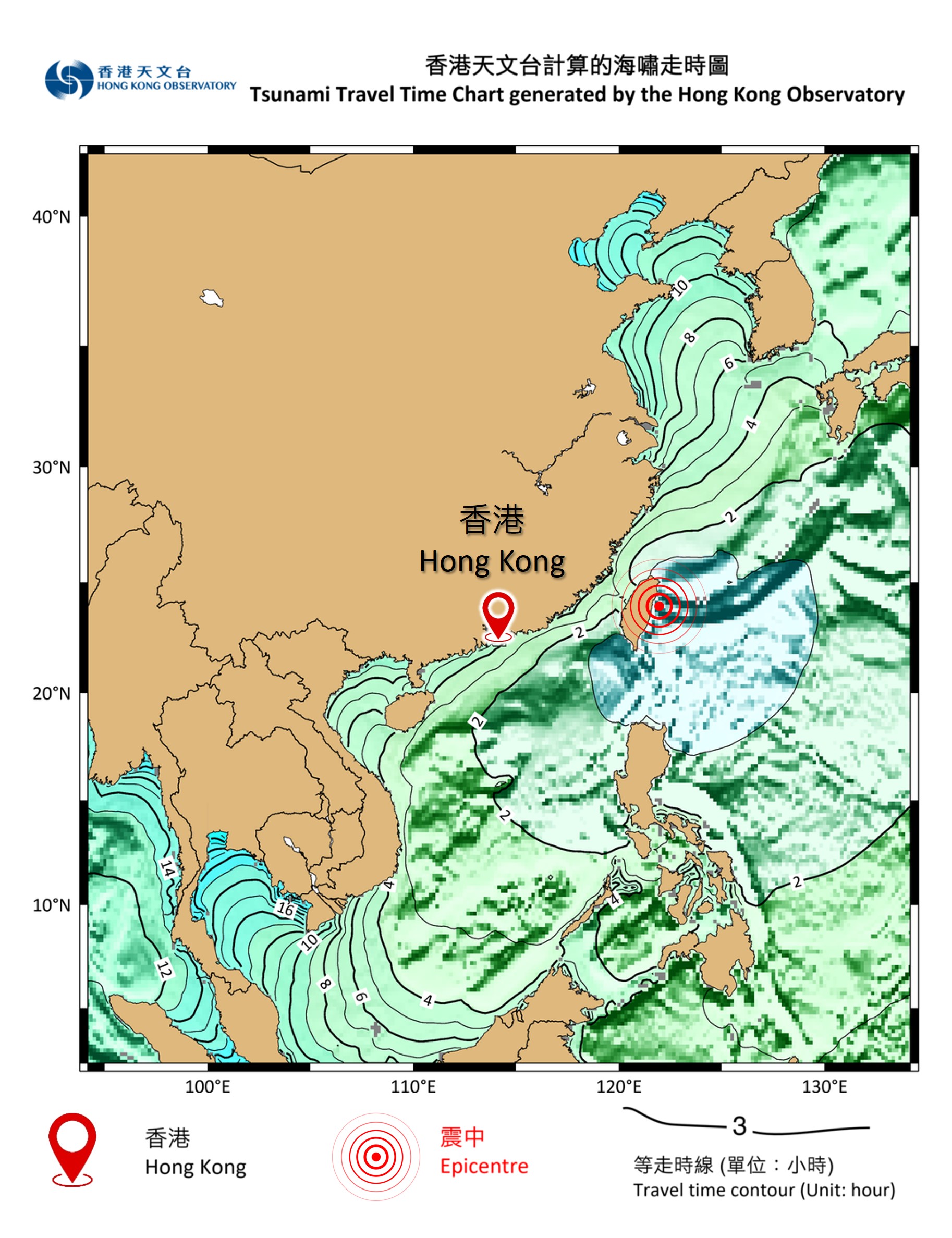
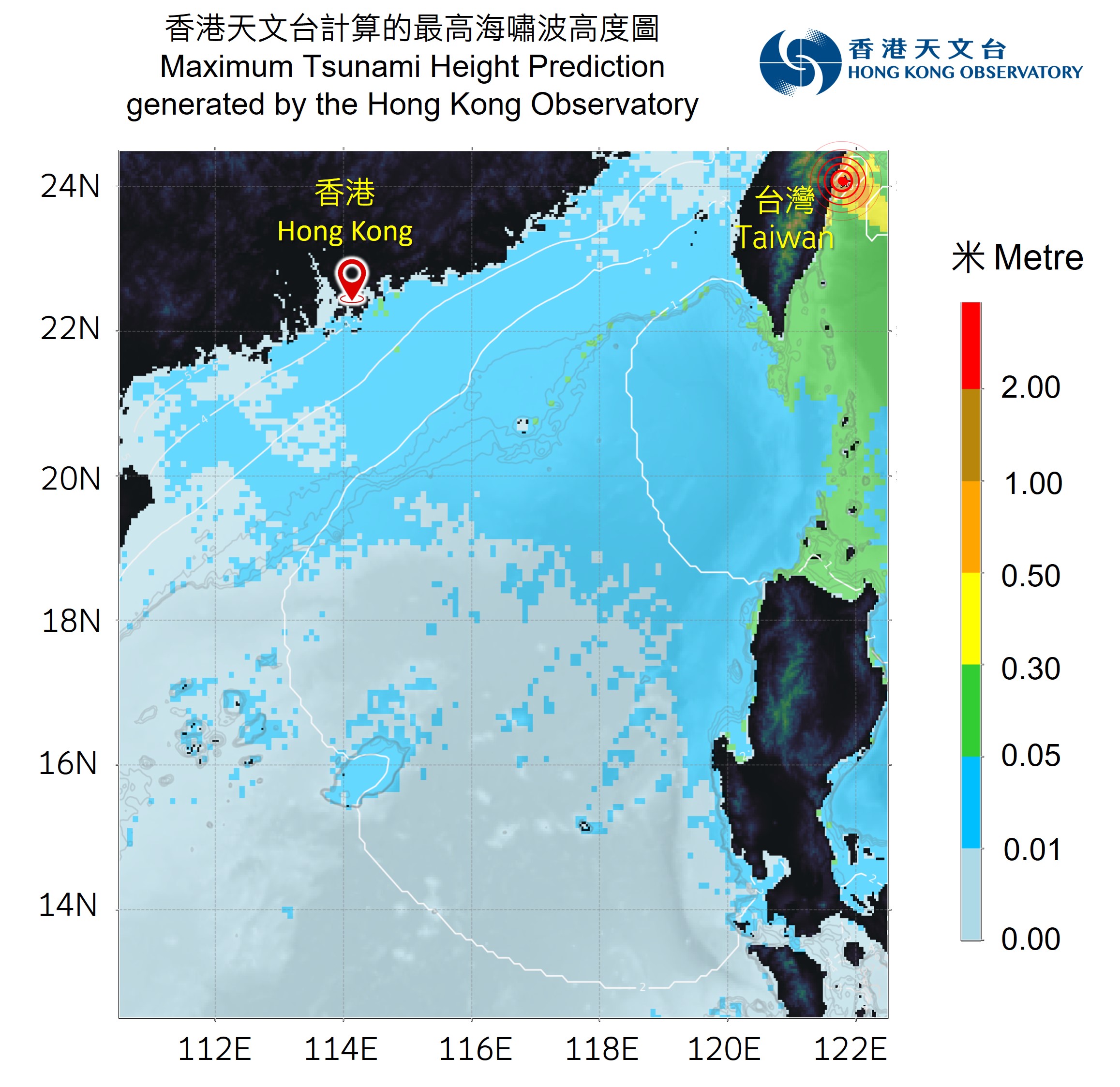
The travelling speed of tsunami waves depend on the depth of water they pass through. The deeper the water, the faster the speed. Based on the dataset of ocean depth, tsunami travel time (TTT) chart can be compiled for different parts of the world after knowing the location of the source of tsunami wave generation. Figure 8 shows the TTT chart indicating that the tsunami wave triggered by the 2024 Hualian earthquake event would take 4-5 hours to reach Hong Kong, and the estimated arrival time (ETA) of tsunami waves would thus be noon to 1 p.m. on 3 April 2024. The computer simulation results in Figure 9 indicated that tsunami wave height over the South China Sea was forecast to be less than 0.05 m.
8. How to analyse tsunami wave height from tide gauge observation? What were the sea level anomalies brought by the tsunami associated with the Hualian earthquake?
Tide gauges are instrumental in measuring the height of the water surface relative to a reference point. They record the changes in water level over time, capturing regular tidal variations as well as other fluctuations, including those caused by tsunamis. Tsunami waves have distinct characteristics that differentiate them from tidal waves.
While tides typically have periods of around 12 or 24 hours, tsunami waves have much shorter periods ranging from a few minutes to a couple of hours. By filtering the specific range of periods in the water level time series, especially at the time of expected arrival of tsunamis and thereafter, we can analyse how much water level fluctuations were likely contributed by tsunami waves.
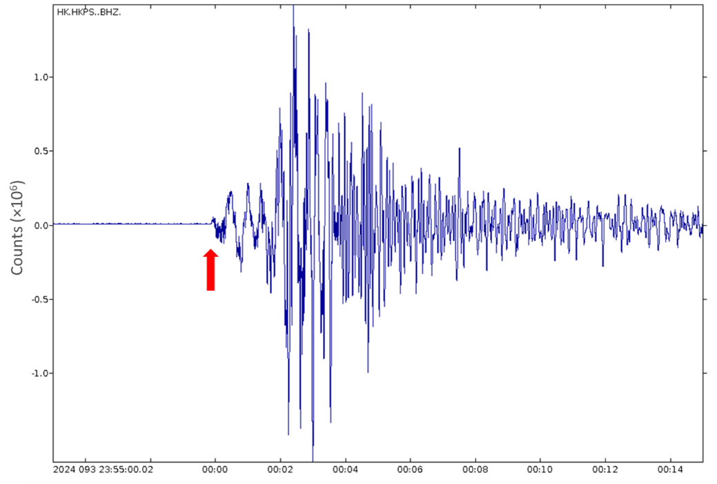
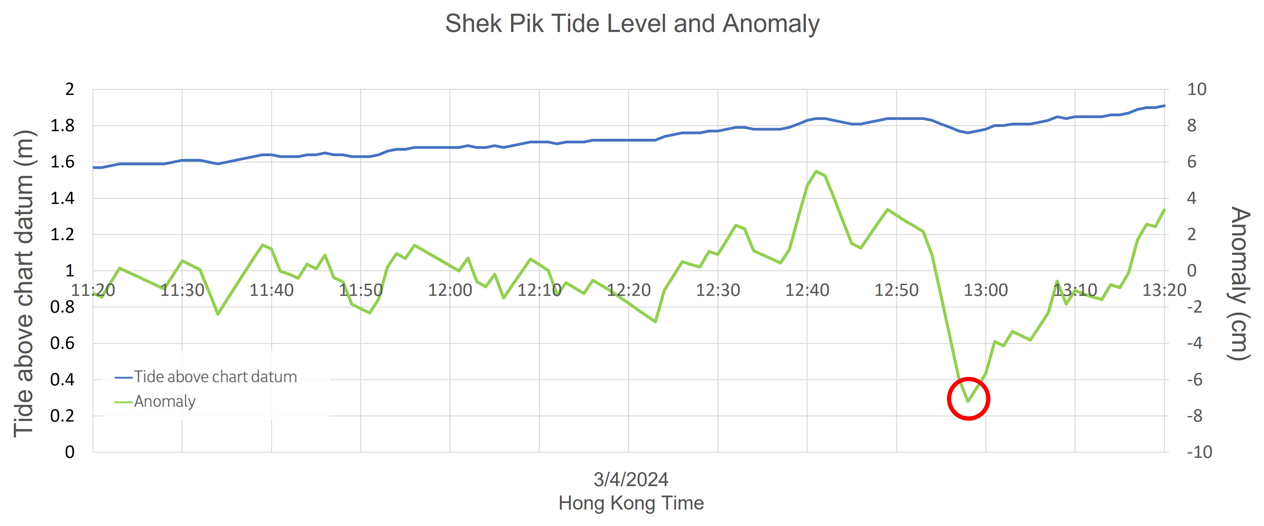
The Hualian earthquake on 3 April 2024 triggered tsunami waves and generally less than around 1 metre of tsunami waves were recorded in Taiwan. The tsunami waves spread across the Pacific Ocean and the South China Sea. Around 0.2 m was recorded in Ishihakijima, Japan. The tsunami waves reached Hong Kong between noon and 1 p.m. that day with a maximum anomaly of 7 cm and a wave period of around 50 minutes at Shek Pik (Figure 10), 4 - 5 hours after the occurrence of the earthquake. The arrival time generally matched with the time estimated by the TTT chart. Minor fluctuations in the sea level were also observed in Tai O and Tai Miu Wan.
9. When will the Observatory issue Tsunami Information Bulletin and Tsunami Warning?
If a severe earthquake in the South China Sea or the Pacific Ocean is expected to generate a tsunami resulting in a significant tsunami (i.e. a tsunami with a height of 0.5 m or more above the normal tide level) in Hong Kong and the ETA of the tsunami at Hong Kong is within 3 hours, the Observatory will issue a Tsunami Warning to alert members of the public to take precautions.
For significant tsunamis that are not expected to reach Hong Kong in 3 hours, the Hong Kong Observatory would issue a Tsunami Information Bulletin to notify members of the public. In addition, the Observatory would also issue Tsunami Information Bulletins for insignificant tsunamis expected in Hong Kong.
10. Is Hong Kong vulnerable to earthquake and tsunami?
Most earthquakes of the world occur along the boundaries of crustal tectonic plates. Hong Kong lies within the Eurasian Plate and is at a distance from the nearest plate boundary. It is not located at an active seismic belt. According to the assessment of the Geotechnical Engineering Office (GEO) of the Civil Engineering and Development Department, the earthquake risk in Hong Kong is low to medium [10]. Notwithstanding this, members of the public should know more about earthquakes and understand the safety rules during and after earthquakes, especially when they travel in areas where earthquakes frequently occur.
Most tsunamis are generated by submarine earthquakes. Hong Kong has not been seriously affected by any tsunami in recorded history, with the Philippines Islands and Taiwan acting as an almost complete breakwater for such tsunamis in the Pacific. Diffracted sea waves are much weaker and therefore the energy that arrives in Hong Kong has been fairly small.
References
[1] HKO’s webpage on locally felt earth tremors
[2] Wikipedia on the 2024 Hualian earthquake
[3] CWA Seismological Center’s webpage
[4] CWA popular science webpage (Chinese only)
[5] USGS webpage
[6] IRIS video on earthquake focal mechanisms
[7] HKO’s webpage on earthquake magnitude
[8] HKO's webpage on Modified Mercarlli Scale
[9] HKO’s webpage on earthquake safety rules
[10] GEO, 2022: Seismicity of Hong Kong