Overview of Tropical Cyclones in October 2013
(Tracks)
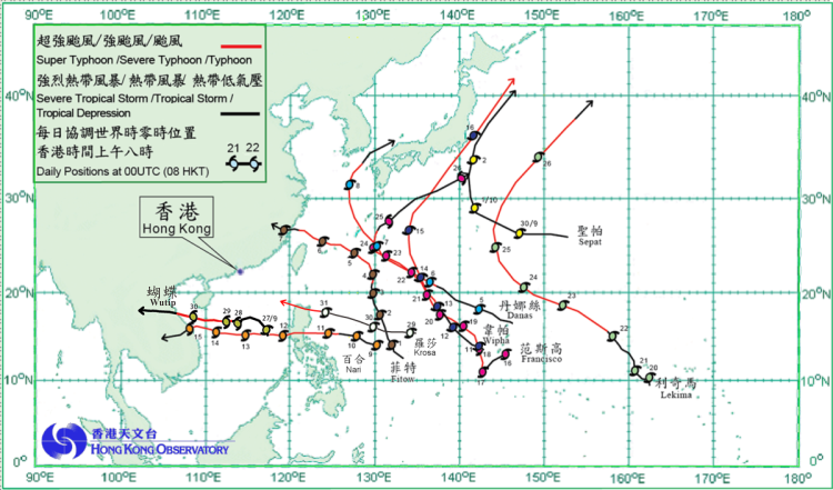
Nine tropical cyclones occurred over the western North Pacific and the South China Sea in October 2013.
Wutip formed as a tropical depression over the central part of the South China Sea about 580 km east-southeast of Xisha on 26 September and moved generally northwestwards. It intensified into a tropical storm the following day. Wutip took on a westerly track across the seas east of Xisha and intensified into a severe tropical storm on 28 September. It passed to the south of Xisha the following day and intensified gradually into a severe typhoon, reaching its peak intensity with estimated sustained winds of 155 km/h near its centre. Wutip weakened into a typhoon that night. It made landfall over the coast of central Vietnam on 30 September and weakened into a severe tropical storm. Wutip dissipated near the border between Laos and Thailand on 1 October. Three fishing boats sank over the waters near Xisha during the passage of Wutip. Four fishermen were killed and 58 others were reported missing. In Vietnam, three people were killed, 35 people were injured and 95 000 houses were destroyed.
Sepat formed as a tropical depression over the western North Pacific about 970 km east of Iwo Jima on 29 September and moved west to west-northwestwards. It intensified into a tropical storm the next day. Sepat reached its peak intensity with estimated sustained winds of 75 km/h near its centre on 1 October and turned northwards. After skirting the seas off southeastern Japan on 2 October, Sepat evolved into an extratropical cyclone the following day.
Fitow formed as a tropical depression over the western North Pacific about 1 250 km east of Manila on 30 September and moved generally north-northwestwards. It intensified gradually into a typhoon over the three days. Fitow turned to move west-northwestwards near Ryukyu Islands on 5 October and intensified into a severe typhoon, reaching its peak intensity with estimated sustained winds of 155 km/h near its centre. It crossed the seas north of Taiwan the following day and weakened into a typhoon. After making landfall over the coast of Fujian in the small hours on 7 October, Fitow weakened rapidly and dissipated inland that evening. According to press reports, five people were killed, four others were missing, around 2 300 houses collapsed and 180 000 hectares of farmland were inundated during the passage of Fitow with direct economic loss exceeding 4.7 billion RMB.
Danas formed as a tropical depression over the western North Pacific about 370 km north-northeast of Guam on 4 October. Moving west-northwestwards, Danas intensified gradually and became a typhoon on 6 October. It intensified further into a super typhoon east-southeast of Okinawa the following day, reaching its peak intensity with estimated sustained winds of 195 km/h near its centre and passing to the northeast of Okinawa on a northwesterly track. It turned gradually northeastwards across the seas west of Japan on 8 October and weakened gradually into a severe tropical storm. Danas became an extratropical cyclone over the Sea of Japan the next day. During the passage of Danas, flooding was reported in Jeju and parts of southern Korea and electricity supply was interrupted.
Nari formed as a tropical depression over the western North Pacific about 1 000 km east of Manila on 9 October and moved west to west-northwestwards. It gradually intensified and became a typhoon to the east of Luzon on 11 October, reaching its peak intensity with estimated sustained winds of 145 km/h near its centre. Nari swept past Luzon that night and tracked across the central part of the South China Sea over the next three days, passing to the south of Xisha. It made landfall over the coast of central Vietnam on 15 October, weakening gradually into a tropical depression and dissipating over Laos that night. In the Philippines, 13 people were killed and more than two million people were left without electricity supply. In Vietnam, five people were killed and 49 people were injured.
Wipha formed as a tropical depression over the western North Pacific about 200 km west of Guam on 10 October and moved west-northwestwards. It gradually intensified into a severe tropical storm and took on a northwesterly track the following day. Wipha intensified into a severe typhoon to the south-southwest of Iwo Jima on 13 October, reaching its peak intensity the following day with estimated sustained winds of 175 km/h near its centre. It turned northeastwards across the seas south of Japan on 15 October and weakened into a typhoon. After crossing the coastal waters of eastern Japan the next day, Wipha became an extratropical cyclone. Wipha brought flash floods and triggered landslides in eastern Japan, where at least 17 people were killed, 51 people were missing and 20 people were injured in Japan. Around 300 houses collapsed or were damaged, and over 30 000 households were left without electricity.
Francisco formed as a tropical depression over the western North Pacific about 80 km southeast of Guam on 16 October and moved southwestwards initially. Francisco intensified into a typhoon the following day and turned to move northwest to north-northwestwards. It intensified further into a super typhoon on 18 October, reaching its peak intensity the following day with estimated sustained winds of 230 km/h near its centre. Francisco weakened into a severe typhoon on 21 October and further into a typhoon two days later. It turned to move northwards across the seas east of Okinawa on 24 October. Francisco weakened into a severe tropical storm on 25 October and moved northeastwards across the seas south of Japan. It evolved into an extratropical cyclone over the Pacific southeast of Japan the following day.
Lekima formed as a tropical depression over the western North Pacific about 1 180 km south-southwest of Wake Island on 20 October and moved generally northwestwards. Lekima gradually intensified over the Pacific, becoming a typhoon in the morning on 22 October and a super typhoon about 1 200 km east-northeast of Guam that evening. It reached its peak intensity with estimated sustained winds of 210 km/h near its centre the following day. Passing to the east of Iwo Jima on 25 October, Lekima gradually took on a northeasterly track and weakened into a typhoon the next day before becoming an extratropical cyclone over the Pacific east of Japan.
Krosa formed as a tropical depression over the western North Pacific about 1 510 km east of Manila on 29 October. Moving generally west to west-northwestwards, Krosa intensified gradually into a severe tropical storm the following day. It intensified further into a typhoon on 31 October and crossed the northern tip of Luzon. In the Philippines, three people were killed, two people were missing and over 17 000 houses were damaged.
|
|---|
Tropical cyclone tracks in October 2013