Overview of Tropical Cyclones in September 2013
(Tracks)
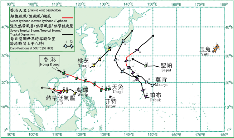
Nine tropical cyclones occurred over the western North Pacific and the South China Sea in September 2013. Amongst them, Usagi necessitated the issuance of tropical cyclone warning signals by the Hong Kong Observatory during the month.
Yutu formed as a tropical depression over the western North Pacific about 1 660 km north-northeast of Wake Island on 1 September and moved northeastwards slowly. It intensified into a tropical storm during the day, reaching its peak intensity with estimated sustained winds of 65 km/h near its centre. Yutu remained slow-moving for the following two days and dissipated over the sea on 4 September.
Toraji formed as a tropical depression over the sea areas about 210 km east-northeast of Taibei on 1 September and moved generally northeastwards. It intensified into a tropical storm west of Okinawa the next day, reaching its peak intensity with estimated sustained winds of 75 km/h near its centre. Toraji made landfall over southern Kyushu, Japan on 4 September and gradually evolved into an extratropical cyclone. According to press reports, around 7 000 people in western Japan were advised to evacuate from their homes due to flooding caused by Toraji.
Man-yi formed as tropical depression over the western North Pacific about 820 km northeast of Guam on 11 September and moved west to west-northwestwards. It intensified into a tropical storm the next day. Moving along a northwesterly track on 14 September, it turned to the north-northeast the next day and intensified further into a severe tropical storm over the seas south of Japan, reaching its peak intensity with estimated sustained winds of 90 km/h near its centre. Man-yi made landfall over southern Honshu, Japan in the morning on 16 September and evolved into an extratropical cyclone over the seas east of Japan that evening. Man-yi brought heavy rain and flooding to widespread areas of Japan, where at least three people were killed, four were reported missing and over 100 people were injured. Electricity supply to over 17 000 households was disrupted.
Usagi formed as a tropical depression over the western North Pacific about 1 240 km east-northeast of Manila on 17 September. Moving generally westwards, it gradually intensified and became a typhoon the next day. Usagi took on a northwesterly track and intensified further into a super typhoon over the Pacific to the east of Luzon on 19 September, reaching its peak intensity with estimated sustained winds of 205 km/h near its centre the next day. Moving west-northwestwards, Usagi crossed the Luzon Strait on 21 September and entered the South China Sea, weakening into a severe typhoon. It moved across the northeastern part of the South China Sea on 22 September, made landfall near Shanwei, Guangdong that evening and moved across the coastal areas of Guangdong during the night. Usagi dissipated over the inland region of Guangxi the following day.
A tropical depression formed over the central part of the South China Sea about 320 km east of Danang on 18 September and moved west to west-northwestwards across the seas south of Hainan Island. The estimated maximum sustained winds near its centre was about 55 km/h. The tropical depression dissipated over land after making landfall over the central part of Vietnam the following day.
Pabuk formed as a tropical depression over the western north Pacific about 400 km east of Guam on 19 September and moved westwards generally. It turned northwest to north-northwestwards the following day and intensified into a tropical storm. Pabuk continued to intensify into a severe tropical storm on 22 September and became a typhoon near Iwo Jima two days later, reaching its peak intensity with estimated sustained winds of 120 km/h near its centre. It turned to move northeastwards over the Pacific to the south of Japan on 25 September and became an extratropical cyclone to the east of Japan the following day.
Wutip formed as a tropical depression over the central part of the South China Sea about 580 km east-southeast of Xisha on 26 September and moved generally northwestwards. It intensified into a tropical storm the following day. Wutip took on a westerly track across the seas east of Xisha and intensified into a severe tropical storm on 28 September. It passed to the south of Xisha the following day and intensified gradually into a severe typhoon, reaching its peak intensity with estimated sustained winds of 155 km/h near its centre. Wutip weakened into a typhoon that night. It made landfall over the coast of central Vietnam on 30 September and weakened into a severe tropical storm. Three fishing boats sank over the waters near Xisha during the passage of Wutip. Four fishermen were killed and 58 others were reported missing. In Vietnam, three people were killed, 35 people were injured and 95 000 houses were destroyed.
Sepat formed as a tropical depression over the western North Pacific about 970 km east of Iwo Jima on 29 September. It moved west to west-northwestwards across the Pacific southeast of Japan during the last two days of the month.
Fitow formed as a tropical depression over the western North Pacific about 1 250 km east of Manila on 30 September and moved north-northwestwards across the Pacific east of the Philippines.
|
|---|
Tropical cyclone tracks in September 2013