Anomalous appearance of a hole and concentric rings in weather radar images
The 3-dimensional weather radar images are generated with data from two weather radars of the Observatory. When only one radar is available to prepare the image, a hole and concentric rings centring on the radar may occasionally appear on 3-dimensional images (see example in Figure 1), particularly when an extensive rain area covers Hong Kong.
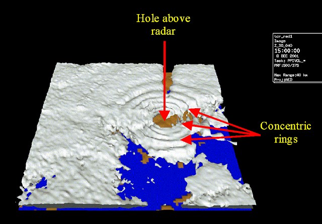
Figure 1 3-dimensional radar image of the Tate's Cairn weather radar at 3 p.m. on 8 December 2001
showing a hole and several concentric rings above Tate's Cairn.
Hole
The occurrence of a hole is related to the operation of the radar. As shown in Figure 2, a radar scans the atmosphere continuously, starting from a low elevation angle and moving up in discrete steps. Once reaching the maximum angle, the radar will return to the lowest position and start again. Therefore, there is no data in the region right above the radar. The data void appears as a clear area in the 3-dimensional image giving the impression of a hole.
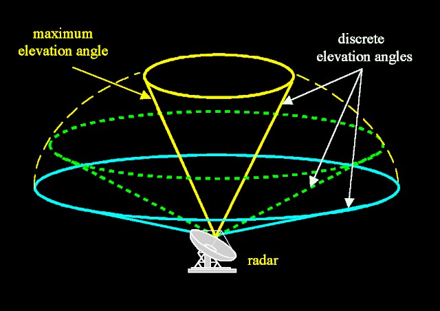
Figure 2 A radar scans the atmosphere at discrete elevation angles.
Concentric rings
The occurrence of concentric rings is a false visual phenomenon arising from the way 3-dimensional radar information is computed. This involves projecting data from radar scans onto discrete horizontal planes. As there is no information beyond the maximum elevation angle, no radar data is available within an inverted conical region above the radar (see yellow cone in Figure 2). This data void region, when projected onto the discrete horizontal planes, appears as hollow circular area on individual planes (see a 3-dimensional perceptive view in Figure 3 below). The higher the altitude of the horizontal plane, the larger will be such circular area. The radar data thus projected onto the discrete horizontal planes are used to produce the 3-dimensional radar images. The apparent discontinuity of radar data at the boundary of these circular data void regions on these horizontal planes gives the impression of concentric rings (see Figure 1).
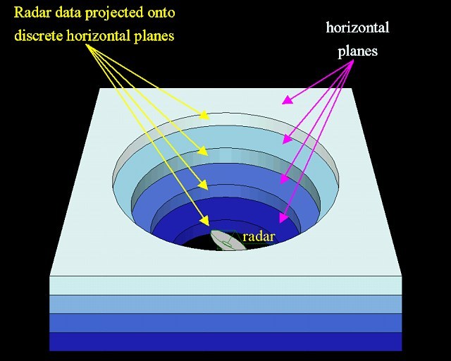
Figure 3 Three dimensional view of radar data on horizontal planes.
Interpretation of radar images
Hole and concentric rings are artificial features arising from the data void region above a radar. Since the size of the data void region does not normally change with time, the size of the hole and the concentric rings also remain unchanged with time, making them easily identifiable on the 3-dimensional radar images. Care should be taken in interpreting radar images with a hole and concentric rings. They should not be confused with region with no rain.
When two nearby radars are operating at the same time, information from one radar would fill up the void above the other radar. Thus, a hole would not appear and concentric rings would become much less apparent (see example in Figure 4).
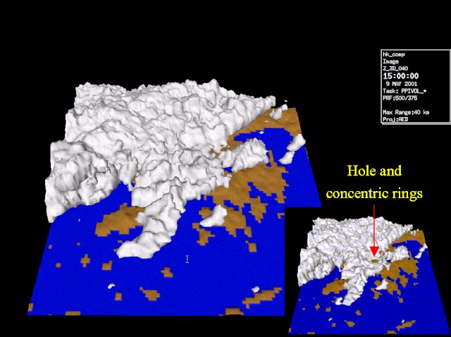
Figure 4 3-dimensional radar image at 3 p.m. on 9 May 2001, generated by information from both the Tai Mo Shan and the Tate's Cairn weather radars. The inset is an image generated by information from the Tai Mo Shan weather radar only, showing a hole and concentric rings above the radar.