The Weather of September 2018
3 October 2018
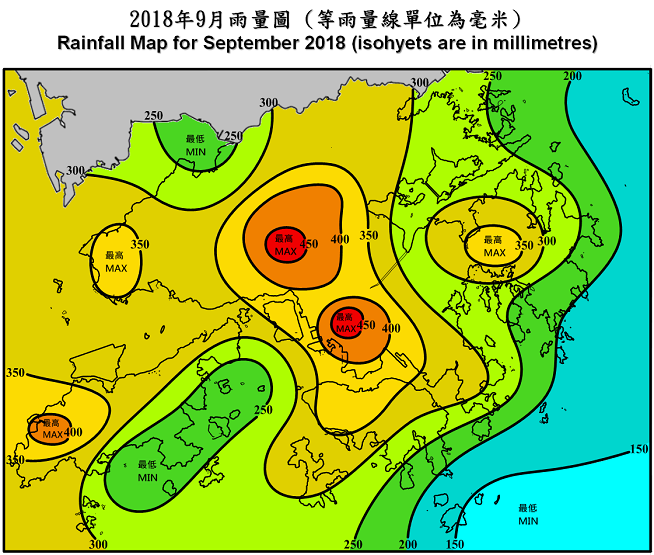
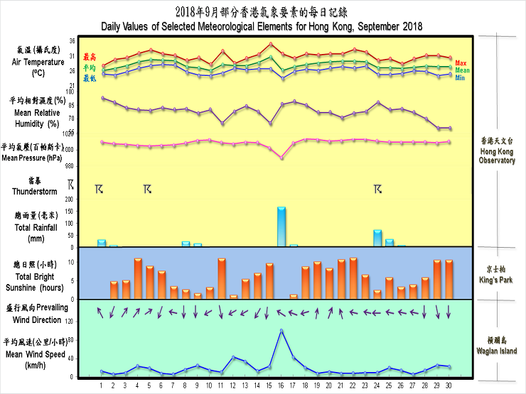
September 2018 was marked by the ferocious strike of severe typhoon Mangkhut which necessitated the issuance of the No. 10 Hurricane Signal in Hong Kong for 10 hours on 16 September. This is the second longest duration of No. 10 Hurricane Signal in Hong Kong since 1946, just next to the record of 11 hours set by Typhoon York in 1999. Mainly attributing to the rainfall brought by Mangkhut, the month was wetter than usual. The monthly rainfall was 383.3 millimetres, about 17 percent above the normal of 327.6 millimetres in September. The accumulated rainfall recorded in the first nine months of the year was 1973.3 millimetres, a deficit of 12 percent compared to the normal of 2233.1 millimetres for the same period. The month was also hotter than usual with a mean temperature of 28.0 degrees, 0.3 degrees above normal of 27.7 degrees.
Under the influence of a trough of low pressure, the weather in Hong Kong was mainly cloudy with occasional heavy showers and thunderstorms on 1 September. More than 30 millimetres of rainfall were recorded over most parts of the territory, and rainfall even exceeded 70 millimetres over Sai Kung and Cheung Chau. With the trough of low pressure weakening gradually, there were sunny periods and a few showers on 2 - 3 September. An anticyclone aloft southern China brought generally fine weather to the territory on 4 September.
Under light wind conditions, it was very hot with sunny periods on 5 - 7 September. High temperatures also triggered thundery showers in the afternoon over Sai Kung and parts of the New Territories in these few days. As a cold front moved across southern China on the night of 7 September, local weather became mainly cloudy with some showers on 8 September. More than 20 millimetres of rainfall were recorded over parts of the urban areas, and rainfall even exceeded 40 millimetres over Happy Valley. The northeast monsoon associated with the cold front brought a few showers and slightly cooler weather to Hong Kong on 8 - 10 September.
Meanwhile, an area of low pressure over the Luzon Strait intensified into a tropical storm and was named as Barijat on 11 September. It moved westwards across the northern part of the South China Sea on the next day. Barijat then moved across Leizhou Peninsula and weakened gradually on 13 September, and dissipated over inland Guangxi afterwards. Under the influence of the outer subsiding air of Barijat, the weather of Hong Kong was generally fine on 11 September. Local weather became showery and windier on 12 September when Barijat skirted past to the south of Hong Kong. With winds subsiding gradually, apart from a few showers at first, there were sunny periods on 13 September.
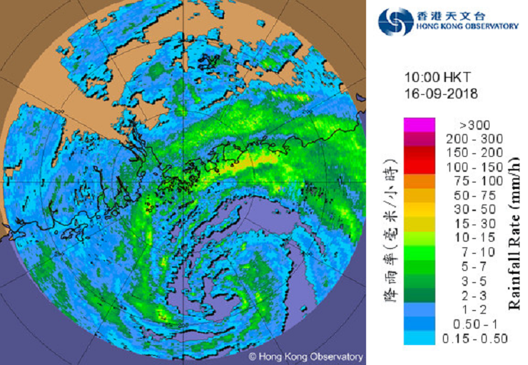
Meanwhile over the western North Pacific, Super Typhoon Mangkhut tracked northwestwards on 14 September and made landfall over Luzon in the small hours of 15 September. After crossing the northern part of Luzon, Mangkhut continued to track northwestwards quickly across the northern part of the South China Sea on 15 September, edging towards the coast of Guangdong. Mangkhut weakened into a severe typhoon on the morning of 16 September and skirted about 100 km south-southwest of Hong Kong in the afternoon. It made landfall over the vicinity of Taishan of Guangdong before dusk and moved into western part of Guangdong. Mangkhut degenerated into an area of low pressure over Guangxi the next night.
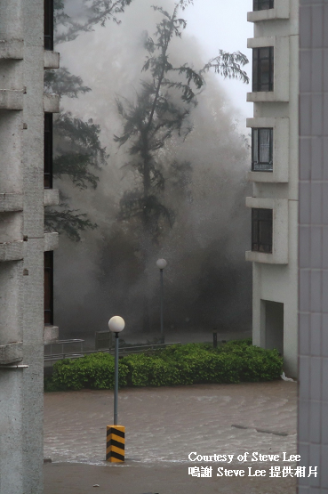
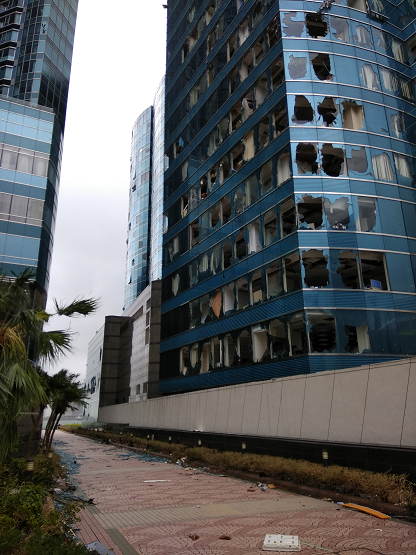
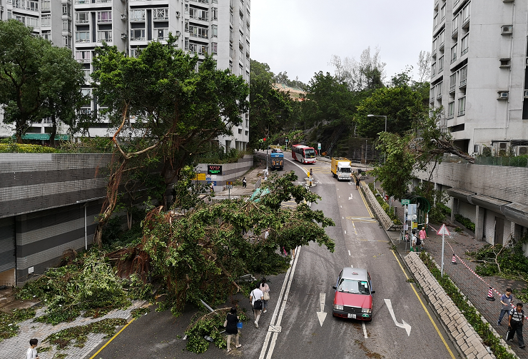
Locally, the outer subsiding air of Mangkhut brought generally fine weather to Hong Kong on 14 – 15 September. It was also very hot on 15 September with the temperature at the Hong Kong Observatory soaring to 35.1 degrees, the highest of the month and the second highest on record for September. With the approach of Mangkhut, local winds strengthened on the night of 15 September. The weather in Hong Kong deteriorated rapidly during the passage of Mangkhut on 16 September. The destructive storm to hurricane force winds, severe storm surge and squally heavy rain associated with Mangkhut ravaged the territory and caused extensive damages to Hong Kong on that day, including serious flooding in many coastal and low-lying areas, substantial damages of coastal structures and buildings, huge amount of fallen trees, many reports of smashed windows or glass curtain walls, and interruptions of water and power supply in some places. Over 450 people were also injured during the stormy weather. Traffic and transportation services were also seriously affected on 16 – 17 September. The maximum 60-minute mean wind speeds recorded at Waglan Island and Cheung Chau were 161 km/h and 157 km/h respectively. Both are the second highest record at the corresponding stations. The storm surge induced by Mangkhut resulted in unusually high water level in many parts of Hong Kong. The water levels at Quarry Bay of the Victoria Harbour rose to a maximum of 3.88 metres above Chart Datum on the afternoon of 16 September 2018, the second highest since 1954 and only lower than the record high of 3.96 metres above Chart Datum set by Super Typhoon Wanda in 1962. Moreover, the maximum storm surge (above astronomical tide) induced by Mangkhut at Quarry Bay was 2.35 metres which was the highest on record, breaking the previous record of 1.77 metres kept by Wanda in 1962. More than 100 millimetres of rainfall were generally recorded over Hong Kong, and rainfall even exceeded 200 millimetres over parts of the territory on that day. During the downpour, the temperature at the Hong Kong Observatory fell to a minimum of 23.6 degrees, the lowest in the month. With Mangkhut departing from Hong Kong, local winds subsided gradually on 17 September, but the outer rainbands associated with Mangkhut continued to bring squally showers to Hong Kong on that day.
With the subtropical ridge extending westwards, apart from a few morning showers, local weather became fine during the day on 18 September. The weather over Hong Kong remained generally fine and hot on 19 – 22 September. Under light wind situation, isolated thunderstorms triggered by high temperatures also brought more than 10 millimetres of rainfall to parts of the New Territories on the afternoon 23 September.
With the setting in of an easterly airstream, local weather became slightly cooler and mainly cloudy with occasional showers and thunderstorms on 24 - 25 September. Showers were heavy on the morning of 24 September with more than 30 millimetres of rainfall generally recorded over the territory and rainfall even exceeding 70 millimetres over Tai Po, Kwai Tsing and Kowloon. As the easterly airstream moderated gradually, local weather was marked by a mixture of sunshine and showers on 26 - 27 September. Apart from one or two morning showers on 28 and 29 September, the weather in Hong Kong became generally fine and dry towards the end of the month as affected by the northeast monsoon.


Five tropical cyclones occurred over the South China Sea and the western North Pacific in the month.
Details of issuance and cancellation of various warnings/signals in the month are summarized in Tables 1.1 to 1.7. Monthly meteorological figures and departures from normal for September are tabulated in Table 2.
Warnings and Signals issued in September 2018
| Name of Tropical Cyclone |
Signal Number |
Beginning Time | Ending Time | ||
|---|---|---|---|---|---|
| Day/Month | HKT | Day/Month | HKT | ||
| BARIJAT | 1 | 11 / 9 | 1040 | 12 / 9 | 1220 |
| 3 | 12 / 9 | 1220 | 13 / 9 | 0410 | |
| 1 | 13 / 9 | 0410 | 13 / 9 | 0740 | |
| MANGKHUT | 1 | 14 / 9 | 2220 | 15 / 9 | 1620 |
| 3 | 15 / 9 | 1620 | 16 / 9 | 0110 | |
| 8 NE | 16 / 9 | 0110 | 16 / 9 | 0740 | |
| 9 | 16 / 9 | 0740 | 16 / 9 | 0940 | |
| 10 | 16 / 9 | 0940 | 16 / 9 | 1940 | |
| 8 SE | 16 / 9 | 1940 | 17 / 9 | 0520 | |
| 3 | 17 / 9 | 0520 | 17 / 9 | 1440 | |
| 1 | 17 / 9 | 1440 | 17 / 9 | 1910 | |
| Colour | Beginning Time | Ending Time | ||
|---|---|---|---|---|
| Day/Month | HKT | Day/Month | HKT | |
| Amber | 1 / 9 | 1255 | 1 / 9 | 1415 |
| Amber | 2 / 9 | 0740 | 2 / 9 | 0945 |
| Amber | 16 / 9 | 0910 | 16 / 9 | 1055 |
| Red | 16 / 9 | 1055 | 16 / 9 | 1850 |
| Amber | 16 / 9 | 1850 | 16 / 9 | 2230 |
| Amber | 24 / 9 | 1010 | 24 / 9 | 1200 |
| Beginning Time | Ending Time | ||
|---|---|---|---|
| Day/Month | HKT | Day/Month | HKT |
| 16 / 9 | 1420 | 17 / 9 | 1120 |
| Beginning Time | Ending Time | ||
|---|---|---|---|
| Day/Month | HKT | Day/Month | HKT |
| 1 / 9 | 0755 | 1 / 9 | 1900 |
| 2 / 9 | 0645 | 2 / 9 | 1100 |
| 3 / 9 | 1055 | 3 / 9 | 1215 |
| 5 / 9 | 1655 | 5 / 9 | 1945 |
| 6 / 9 | 1240 | 6 / 9 | 1430 |
| 7 / 9 | 0520 | 7 / 9 | 0800 |
| 7 / 9 | 1155 | 7 / 9 | 1330 |
| 7 / 9 | 2225 | 8 / 9 | 0715 |
| 8 / 9 | 1340 | 8 / 9 | 1500 |
| 14 / 9 | 1720 | 14 / 9 | 1830 |
| 17 / 9 | 0430 | 17 / 9 | 0630 |
| 23 / 9 | 1545 | 23 / 9 | 1845 |
| 24 / 9 | 0705 | 24 / 9 | 1330 |
| 24 / 9 | 2005 | 24 / 9 | 2340 |
| Colour | Beginning Time | Ending Time | ||
|---|---|---|---|---|
| Day/Month | HKT | Day/Month | HKT | |
| Yellow | 25 / 9 | 1000 | 25 / 9 | 1800 |
| Red | 29 / 9 | 0600 | 30 / 9 | 2045 |
| Beginning Time | Ending Time | ||
|---|---|---|---|
| Day/Month | HKT | Day/Month | HKT |
| 5 / 9 | 1215 | 5 / 9 | 1700 |
| 6 / 9 | 0940 | 6 / 9 | 1800 |
| 14 / 9 | 0645 | 15 / 9 | 2315 |
| 21 / 9 | 1145 | 21 / 9 | 1800 |
| 22 / 9 | 1325 | 22 / 9 | 1645 |
| Beginning Time | Ending Time | ||
|---|---|---|---|
| Day/Month | HKT | Day/Month | HKT |
| 16 / 9 | 1125 | 16 / 9 | 2330 |
| 24 / 9 | 1110 | 24 / 9 | 1345 |
| Meteorological Element | Figure of the Month | Departure from Normal* |
|---|---|---|
| Mean Daily Maximum Air Temperature | 31.0 degrees C | 0.9 degree above normal |
| Mean Air Temperature | 28.0 degrees C | 0.3 degree above normal |
| Mean Daily Minimum Air Temperature | 26.0 degrees C | 0.2 degree above normal |
| Mean Dew Point Temperature | 23.7 degrees C | 0.3 degree above normal |
| Mean Relative Humidity | 78 % | normal |
| Mean Cloud Amount | 68 % | 2 % above normal |
| Total Rainfall | 383.3 mm | 55.7 mm above normal |
| Number of hours of Reduced VisibilityΔ | 5 hours | 73.5 hours below normal§ |
| Total Bright Sunshine Duration | 183.3 hours | 11.0 hours above normal |
| Mean Daily Global Solar Radiation | 15.65 Megajoule / square metre | 1.04 Megajoule above normal |
| Total Evaporation | 101.5 mm | 24.4 mm below normal |
| Remarks : | All measurements were made at the Hong Kong Observatory except sunshine,
solar radiation and evaporation which were recorded at King's Park
Meteorological Station and visibility which was observed at the Hong
Kong International Airport. |
| Δ | The visibility readings at the Hong Kong International Airport are based on hourly observations by professional meteorological observers in 2004 and before, and average readings over the 10-minute period before the clock hour of the visibility meter near the middle of the south runway from 2005 onwards. The change of the data source in 2005 is an improvement of the visibility assessment using instrumented observations following the international trend.
Before 10 October 2007, the number of hours of reduced visibility at the Hong Kong International Airport in 2005 and thereafter displayed in this web page was based on hourly visibility observations by professional meteorological observers. Since 10 October 2007, the data have been revised using the average visibility readings over the 10-minute period before the clock hour, as recorded by the visibility meter near the middle of the south runway. |
* Departure from 1981 - 2010 climatological normal, except for number of hours of reduced visibility |
|
§ Departure from mean value between 1997 and 2017 |
|
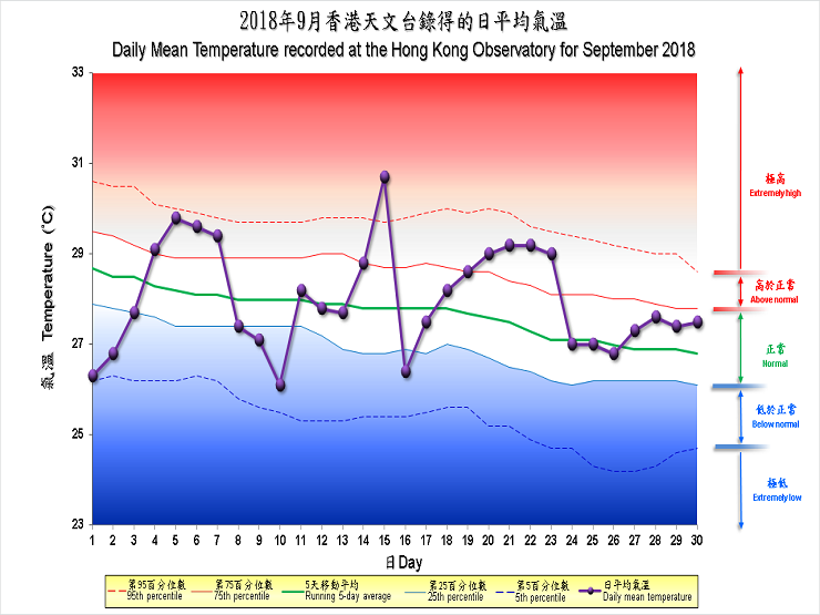
| Remarks : | Extremely high: above 95th percentile Above normal: between 75th and 95th percentile Normal: between 25th and 75th percentile Below normal: between 5th and 25th percentile Extremely low: below 5th percentile Percentile and 5-day running average values are computed based on the data from 1981 to 2010 |
