The Weather of April 2016
4 May 2016
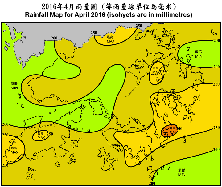
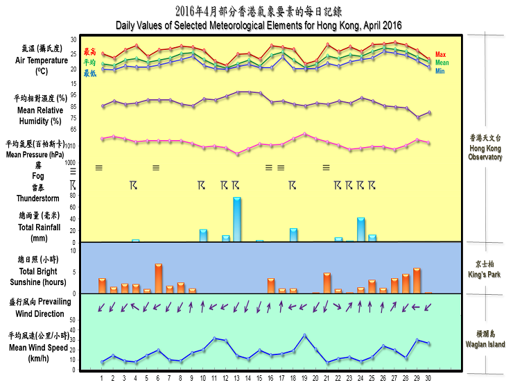
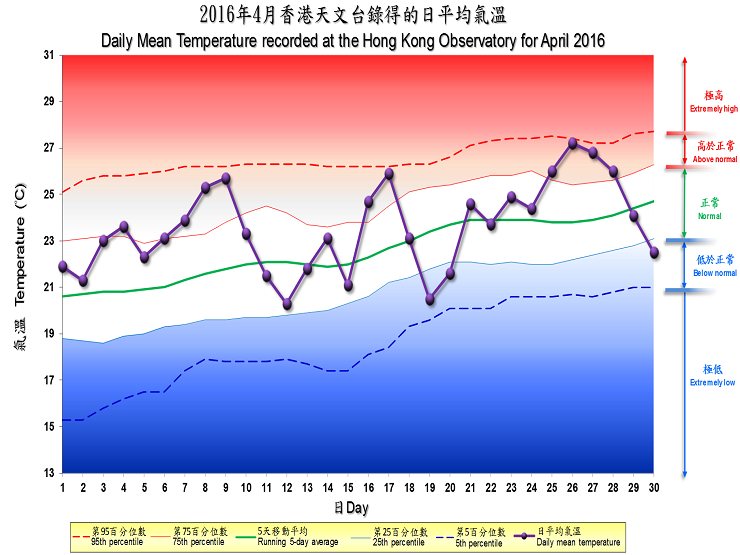
With a maritime airstream trying to exert control over the coastal areas of Guangdong in a change of seasons, the weather of April 2016 was exceptionally humid and gloomy. The monthly mean relative humidity was 89 percent, six percent higher than normal and also the most humid for April since 1961. Under long spells of clouds, fog or mist, the sunshine duration of 6.9 hours on 6 April already made it the sunniest day in the month. The total duration of bright sunshine recorded in the month was only 55.4 hours, around 54 percent of normal and the sixth lowest for April on record. The month was also warmer and rainier than usual. The monthly mean temperature was 23.6 degrees, 1.0 degrees above the normal figure of 22.6 degrees. The monthly total rainfall was 211.4 millimetres, about 21 percent more than the normal figure of 174.7 millimetres. The accumulated rainfall of 651.8 millimetres in the first four months of the year was nearly double the normal figure of 336.1 millimetres for the same period.
Apart from a relatively sunny day on 6 April, the weather in Hong Kong was warm, humid and foggy on the first nine days of the month, with the visibility in the harbour and over the coastal waters occasionally falling to around 100 metres under the influence of a humid maritime airstream. There were also some heavy showers and squally thunderstorms on 4 April, particularly over Lantau Island and the northern part of the New Territories.
With a trough of low pressure edging southwards and crossing the south China coastal areas, local weather became unsettled with outbreak of heavy rain and squally thunderstorms from 10 till 15 April. Again, rain was heaviest over Lantau Island and the northern part of the New Territories on 10 April. Easterly winds then freshened on 11 and 12 April and more widespread heavy rain occurred on the morning of 13 April as an area of intense thunderstorms swept across the coast of Guangdong. More than 50 millimetres of rainfall were generally recorded over Hong Kong that day and severe gusts reaching 113 kilometres per hour were reported at Lau Fau Shan.
As the trough weakened and the rain eased off, some sunny intervals appeared on 16 April. Meanwhile, the setting in of a maritime airstream also brought humid and foggy weather to the territory. With another trough of low pressure crossing the coast of Guangdong on 18 April, the weather turned unsettled again with rain and squally thunderstorms. This was followed by a fresh to strong easterly airstream that brought cooler weather with rain patches to Hong Kong on 19 - 20 April.
After some sunny intervals and fog patches on 21 April, an upper-air disturbance brought thundery showers to Hong Kong on 22 April, with the heaviest rain falling over the northern part of the New Territories. Affected by a trough of low pressure, local weather deteriorated further with scattered heavy showers and squally thunderstorms in the next three days. While the showery conditions persisted in the presence of a lingering trough, the increasing influence of a warm maritime airstream caused temperatures at the Hong Kong Observatory to climb to a maximum of 29.1 degrees on the afternoon of 27 April, the highest of the month. The arrival of an easterly airstream brought slightly cooler weather and a mixture of sunshine and showers towards the end of the month.

There was no tropical cyclone over the South China Sea and the western North Pacific in the month.
Details of issuance and cancellation of various warnings/signals in the month are summarized in Tables 1.1 to 1.2. Monthly meteorological figures and departures from normal for April are tabulated in Table 2.
Warnings and Signals issued in April 2016
| Colour | Beginning Time | Ending Time | ||
|---|---|---|---|---|
| Day/Month | HKT | Day/Month | HKT | |
| Amber | 4 / 4 | 1635 | 4 / 4 | 1925 |
| Amber | 10 / 4 | 0930 | 10 / 4 | 1140 |
| Amber | 13 / 4 | 0630 | 13 / 4 | 1200 |
| Amber | 22 / 4 | 0820 | 22 / 4 | 0945 |
| Beginning Time | Ending Time | ||
|---|---|---|---|
| Day/Month | HKT | Day/Month | HKT |
| 4 / 4 | 1615 | 4 / 4 | 2215 |
| 10 / 4 | 0815 | 10 / 4 | 1530 |
| 11 / 4 | 0650 | 11 / 4 | 1035 |
| 12 / 4 | 1150 | 12 / 4 | 1300 |
| 12 / 4 | 1415 | 12 / 4 | 1630 |
| 12 / 4 | 1745 | 12 / 4 | 2000 |
| 13 / 4 | 0600 | 13 / 4 | 1300 |
| 18 / 4 | 0620 | 18 / 4 | 1030 |
| 22 / 4 | 0740 | 22 / 4 | 1045 |
| 22 / 4 | 1300 | 22 / 4 | 1530 |
| 23 / 4 | 1330 | 23 / 4 | 1600 |
| 24 / 4 | 0820 | 24 / 4 | 1130 |
| 24 / 4 | 1255 | 24 / 4 | 1535 |
| 24 / 4 | 1615 | 24 / 4 | 2015 |
| 25 / 4 | 1400 | 25 / 4 | 1730 |
| 26 / 4 | 0125 | 26 / 4 | 0230 |
| 26 / 4 | 1920 | 26 / 4 | 2030 |
| 27 / 4 | 0045 | 27 / 4 | 0215 |
| 27 / 4 | 0335 | 27 / 4 | 0730 |
| 27 / 4 | 0900 | 27 / 4 | 1000 |
| Meteorological Element | Figure of the Month | Departure from Normal* |
|---|---|---|
| Mean Daily Maximum Air Temperature | 26.0 degrees C | 1.0 degree above normal |
| Mean Air Temperature | 23.6 degrees C | 1.0 degree above normal |
| Mean Daily Minimum Air Temperature | 21.9 degrees C | 1.1 degrees above normal |
| Mean Dew Point Temperature | 21.6 degrees C | 2.2 degrees above normal |
| Mean Relative Humidity | 89 % | 6 % above normal |
| Mean Cloud Amount | 84 % | 3 % above normal |
| Total Rainfall | 211.4 mm | 36.7 mm above normal |
| Number of hours of Reduced VisibilityΔ | 16 hours | 74.6 hours below normal§ |
| Total Bright Sunshine Duration | 55.4 hours | 46.3 hours below normal |
| Mean Daily Global Solar Radiation | 9.39 Megajoule / square metre | 2.21 Megajoule below normal |
| Total Evaporation | 67.5& mm | 16.3 mm below normal |
| Remarks : | All measurements were made at the Hong Kong Observatory except sunshine,
solar radiation and evaporation which were recorded at King's Park
Meteorological Station and visibility which was observed at the Hong
Kong International Airport. |
| Δ | The visibility readings at the Hong Kong International Airport are based on hourly observations by professional meteorological observers in 2004 and before, and average readings over the 10-minute period before the clock hour of the visibility meter near the middle of the south runway from 2005 onwards. The change of the data source in 2005 is an improvement of the visibility assessment using instrumented observations following the international trend.
|
* Departure from 1981 - 2010 climatological normal, except for number of hours of reduced visibility |
|
§ Departure from mean value between 1997 and 2015 |
|
& Data incomplete |
|
| Remarks : | Extremely high: above 95th percentile Above normal: between 75th and 95th percentile Normal: between 25th and 75th percentile Below normal: between 5th and 25th percentile Extremely low: below 5th percentile Percentile and 5-day running average values are computed based on the data from 1981 to 2010 |