The Weather of March 2016
5 April 2016
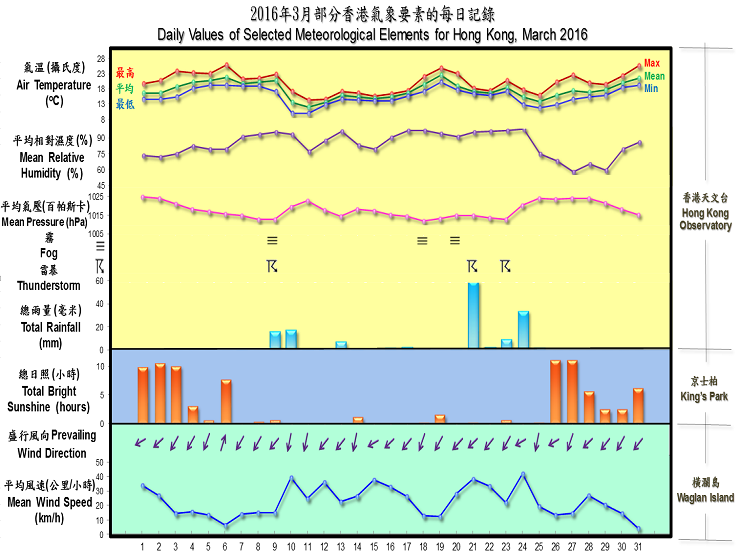
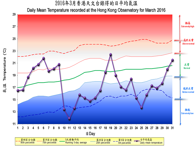
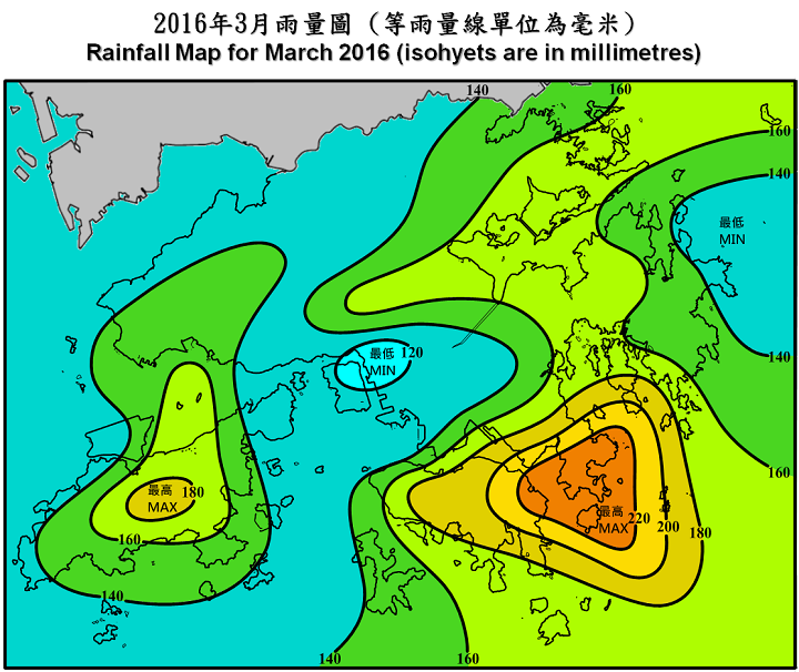
With the northeast monsoon and a humid maritime airstream competing for dominance over the south China coast, March 2016 in Hong Kong was characterized by gloomy, rainy and humid weather with fluctuating temperatures. Overall, the month was cooler than usual with rainfall above normal. The monthly mean temperature was 17.5 degrees, 1.6 degrees lower than the normal figure of 19.1 degrees. The monthly total rainfall was 148.7 millimetres, about 81 percent more than the normal figure of 82.2 millimetres. The accumulated rainfall of 440.4 millimetres in the first three months of the year was about 1.7 times above the normal figure of 161.3 millimetres for the same period.
Under the influence of a relatively dry northeast monsoon, the weather in Hong Kong was generally fine with cool mornings on the first three days of the month. A humid maritime airstream brought cloudy weather to Hong Kong on 4 and 5 March. As the clouds thinned out, sunny periods emerged on 6 March with some mist patches in the morning and temperatures rising to 25.9 degrees in the afternoon, the highest of the month.
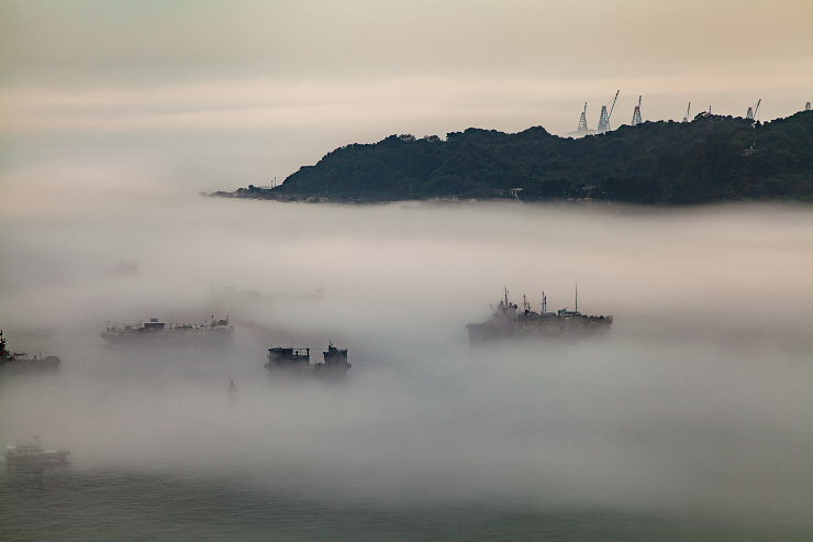
The clouds returned on 7 March, and a long spell of gloomy skies and rainy weather then persisted for the next 18 days. Foggy conditions affected the coastal waters of Guangdong and visibility at Waglan Island once fell to around 100 metres on 8 and 9 March. An intense northeast monsoon following the passage of a cold front on the night of 9 March brought cold weather to Hong Kong over the next couple of days. Temperatures at the Observatory fell to a minimum of 10.0 degrees, the lowest of the month, shortly before midnight on 10 March and during the small hours on 11 March. Affected by replenishments of the northeast monsoon and freshening easterly winds, the weather remained generally cool with mist and rain patches till 17 March.
With the return of a humid maritime airstream, foggy weather affected the south China coast on 18-19 March. Visibility at Waglan Island dropped to around 100 metres and a high-speed passenger vessel crashed into a pile of steel pipes near the Hong Kong-Zhuhai-Macao Bridge on the morning of 19 March. The weather became warmer as temperatures climbed, before the approach of a trough of low pressure and a strengthening easterly airstream brought more unsettled conditions and squally thunderstorms on 21 March. More than 40 millimetres of rainfall were generally recorded over the territory that day. Rainy weather and overcast skies with fog patches and thunderstorms continued to affect Hong Kong over the next couple of days.
The passage of a cold front brought rainy and appreciably cooler conditions to Hong Kong on 24 March. After a cold morning on 25 March, the arrival a dry continental air mass finally cleared away the lingering clouds. Fine and sunny weather prevailed in the next couple of days with the relative humidity falling below 30 percent on 27 March. With the setting in of a mild easterly airstream, generally cloudy weather prevailed over the territory towards the end of the month, and the return of a humid maritime air mass brought mist patches and low visibility to some places on 30-31 March.

There was no tropical cyclone over the South China Sea and the western North Pacific in the month.
Details of issuance and cancellation of various warnings/signals
in the month are summarized in Tables 1.1 to 1.4. Monthly meteorological
figures and departures from normal for March are tabulated in Table 2.
Warnings and Signals issued in March 2016
| Beginning Time | Ending Time | ||
|---|---|---|---|
| Day/Month | HKT | Day/Month | HKT |
| 20 / 3 | 1310 | 22 / 3 | 1345 |
| 24 / 3 | 0550 | 24 / 3 | 1615 |
| Beginning Time | Ending Time | ||
|---|---|---|---|
| Day/Month | HKT | Day/Month | HKT |
| 9 / 3 | 0030 | 9 / 3 | 0500 |
| 9 / 3 | 0655 | 9 / 3 | 0800 |
| 9 / 3 | 1255 | 9 / 3 | 1530 |
| 19 / 3 | 1825 | 19 / 3 | 2000 |
| 21 / 3 | 0545 | 21 / 3 | 1100 |
| 21 / 3 | 1550 | 22 / 3 | 0200 |
| 22 / 3 | 2110 | 23 / 3 | 0015 |
| 23 / 3 | 1350 | 23 / 3 | 1530 |
| 23 / 3 | 2300 | 24 / 3 | 0400 |
| Colour | Beginning Time | Ending Time | ||
|---|---|---|---|---|
| Day/Month | HKT | Day/Month | HKT | |
| Yellow | 6 / 3 | 1130 | 6 / 3 | 1800 |
| Yellow | 25 / 3 | 1345 | 26 / 3 | 0600 |
| Red | 26 / 3 | 0600 | 28 / 3 | 2045 |
| Red | 29 / 3 | 1130 | 29 / 3 | 1820 |
| Beginning Time | Ending Time | ||
|---|---|---|---|
| Day/Month | HKT | Day/Month | HKT |
| 9 / 3 | 1620 | 12 / 3 | 1145 |
| 24 / 3 | 1130 | 27 / 3 | 0830 |
| Meteorological Element | Figure of the Month | Departure from Normal* |
|---|---|---|
| Mean Daily Maximum Air Temperature | 20.0 degrees C | 1.4 degrees below normal |
| Mean Air Temperature | 17.5 degrees C | 1.6 degrees below normal |
| Mean Daily Minimum Air Temperature | 15.7 degrees C | 1.5 degrees below normal |
| Mean Dew Point Temperature | 14.5 degrees C | 1.2 degrees below normal |
| Mean Relative Humidity | 84 % | 2 % above normal |
| Mean Cloud Amount | 79 % | normal |
| Total Rainfall | 148.7 mm | 66.5 mm above normal |
| Number of hours of Reduced VisibilityΔ | 88 hours | 28.7 hours below normal§ |
| Total Bright Sunshine Duration | 84.8 hours | 6.0 hours below normal |
| Mean Daily Global Solar Radiation | 9.58 Megajoule / square metre | 0.38 Megajoule below normal |
| Total Evaporation | 64.0& mm | 6.5 mm below normal |
| Remarks : | All measurements were made at the Hong Kong Observatory except sunshine,
solar radiation and evaporation which were recorded at King's Park
Meteorological Station and visibility which was observed at the Hong
Kong International Airport. |
| Δ | The visibility readings at the Hong Kong International Airport are based on hourly observations by professional meteorological observers in 2004 and before, and average readings over the 10-minute period before the clock hour of the visibility meter near the middle of the south runway from 2005 onwards. The change of the data source in 2005 is an improvement of the visibility assessment using instrumented observations following the international trend.
|
* Departure from 1981 - 2010 climatological normal, except for number of hours of reduced visibility |
|
§ Departure from mean value between 1997 and 2015 |
|
& Data incomplete |
|


| Remarks : | Extremely high: above 95th percentile Above normal: between 75th and 95th percentile Normal: between 25th and 75th percentile Below normal: between 5th and 25th percentile Extremely low: below 5th percentile Percentile and 5-day running average values are computed based on the data from 1981 to 2010 |
