The Weather of September 2013
|
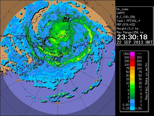
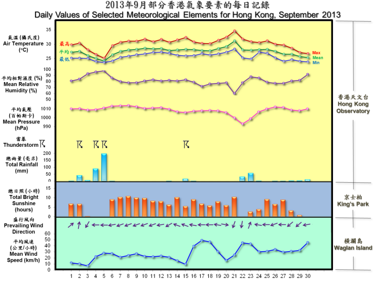
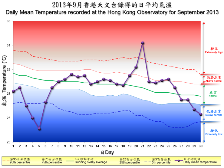
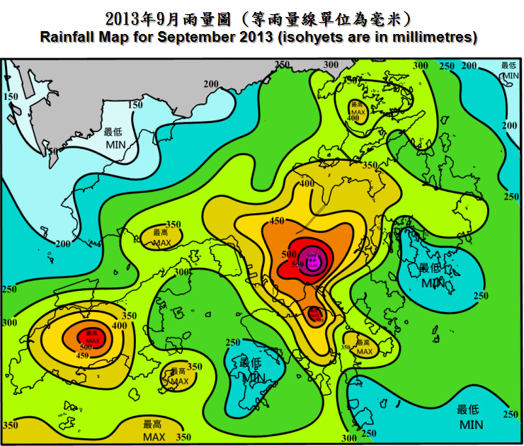
Due to the heavy rain episodes in the early part of the month and the rainfall associated with tropical cyclone Usagi in late September, it was wetter than usual in September 2013. The total rainfall of the month was 454.2 millimetres, about 39 percent above the normal figure of 327.6 millimetres. The accumulated rainfall since 1 January was 2673.0 millimetres, about 20 percent above the normal figure of 2233.1 millimetres for the same period. While the month was overall slightly cooler than normal, the approach of Usagi also brought very hot conditions and high temperatures on 20 and 21 September.  Radar echoes showing Severe Typhoon Usagi skirting within 100 kilometres to the north of Hong Kong on the night of 22 September 2013 |
|
Nine tropical cyclones occurred over the South China Sea and the western North Pacific in the month. |
|
Details of issuance and cancellation of various warnings/signals in the month are summarized in Tables 1.1 to 1.6. Monthly meteorological figures and departures from normal for September are tabulated in Table 2. |
Warnings and Signals issued in September 2013
| Name of Tropical Cyclone |
Signal Number |
Beginning Time | Ending Time | ||
|---|---|---|---|---|---|
| Day/Month | HKT | Day/Month | HKT | ||
| USAGI | 1 | 21 / 9 | 1040 | 21 / 9 | 2340 |
| 3 | 21 / 9 | 2340 | 22 / 9 | 1840 | |
| 8 NW | 22 / 9 | 1840 | 23 / 9 | 0025 | |
| 8 SW | 23 / 9 | 0025 | 23 / 9 | 0920 | |
| 3 | 23 / 9 | 0920 | 23 / 9 | 1025 | |
| Beginning Time | Ending Time | ||
|---|---|---|---|
| Day/Month | HKT | Day/Month | HKT |
| 17 / 9 | 0245 | 19 / 9 | 0440 |
| 30 / 9 | 0830 | 30 / 9 | 2145 |
| Colour | Beginning Time | Ending Time | ||
|---|---|---|---|---|
| Day/Month | HKT | Day/Month | HKT | |
| Amber | 4 / 9 | 0730 | 4 / 9 | 1100 |
| Beginning Time | Ending Time | ||
|---|---|---|---|
| Day/Month | HKT | Day/Month | HKT |
| 2 / 9 | 1730 | 2 / 9 | 2330 |
| 3 / 9 | 0650 | 3 / 9 | 0830 |
| 4 / 9 | 0305 | 4 / 9 | 1330 |
| 5 / 9 | 0740 | 5 / 9 | 1845 |
| 5 / 9 | 2325 | 6 / 9 | 0130 |
| 13 / 9 | 1210 | 13 / 9 | 1415 |
| 15 / 9 | 1235 | 15 / 9 | 1930 |
| 16 / 9 | 0025 | 16 / 9 | 0330 |
| 23 / 9 | 0655 | 23 / 9 | 1030 |
| Colour | Beginning Time | Ending Time | ||
|---|---|---|---|---|
| Day/Month | HKT | Day/Month | HKT | |
| Yellow | 15 / 9 | 0600 | 15 / 9 | 1400 |
| Yellow | 19 / 9 | 1200 | 21 / 9 | 2355 |
| Beginning Time | Ending Time | ||
|---|---|---|---|
| Day/Month | HKT | Day/Month | HKT |
| 20 / 9 | 0800 | 22 / 9 | 0600 |
| Meteorological Element | Figure of the Month | Departure from Normal* |
|---|---|---|
| Mean Daily Maximum Air Temperature | 30.3 degrees C | 0.2 degree above normal |
| Mean Air Temperature | 27.5 degrees C | 0.2 degree below normal |
| Mean Daily Minimum Air Temperature | 25.7 degrees C | 0.1 degree below normal |
| Mean Dew Point Temperature | 23.9 degrees C | 0.5 degree above normal |
| Mean Relative Humidity | 82 % | 4 % above normal |
| Mean Cloud Amount | 67 % | 1 % above normal |
| Total Rainfall | 454.2 mm | 126.6 mm above normal |
| Number of hours of Reduced VisibilityΔ | 26 hours | 68.7 hours below normal§ |
| Total Bright Sunshine Duration | 186.0 hours | 13.7 hours above normal |
| Mean Daily Global Solar Radiation | 15.98 Megajoule / square metre | 1.37 Megajoule above normal |
| Total Evaporation | 126.3 mm | 0.4 mm above normal |
| Remarks : | All measurements were made at the Hong Kong Observatory except sunshine, solar radiation and evaporation which were recorded at King's Park Meteorological Station and visibility which was observed at the Hong Kong International Airport. |
| Δ |
The visibility readings at the Hong Kong International Airport are based on hourly observations by professional meteorological observers in 2004 and before, and average readings over the 10-minute period before the clock hour of the visibility meter near the middle of the south runway from 2005 onwards. The change of the data source in 2005 is an improvement of the visibility assessment using instrumented observations following the international trend. |
* Departure from 1981 - 2010 climatological normal, except for number of hours of reduced visibility |
|
§ Departure from mean value between 1997 and 2012 |
|


| Remarks : | Extremely high: above 95th percentile Above normal: between 75th and 95th percentile Normal: between 25th and 75th percentile Below normal: between 5th and 25th percentile Extremely low: below 5th percentile Percentile and 5-day running average values are computed based on the data from 1981 to 2010 |
