The Weather of July 2013
|
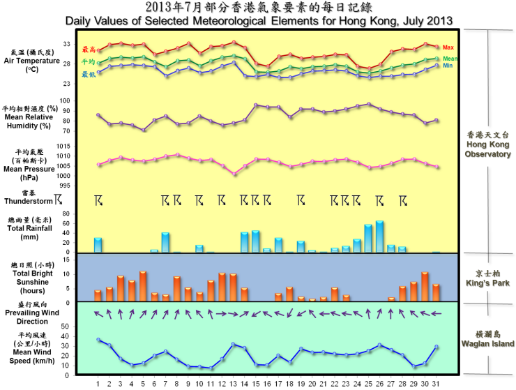
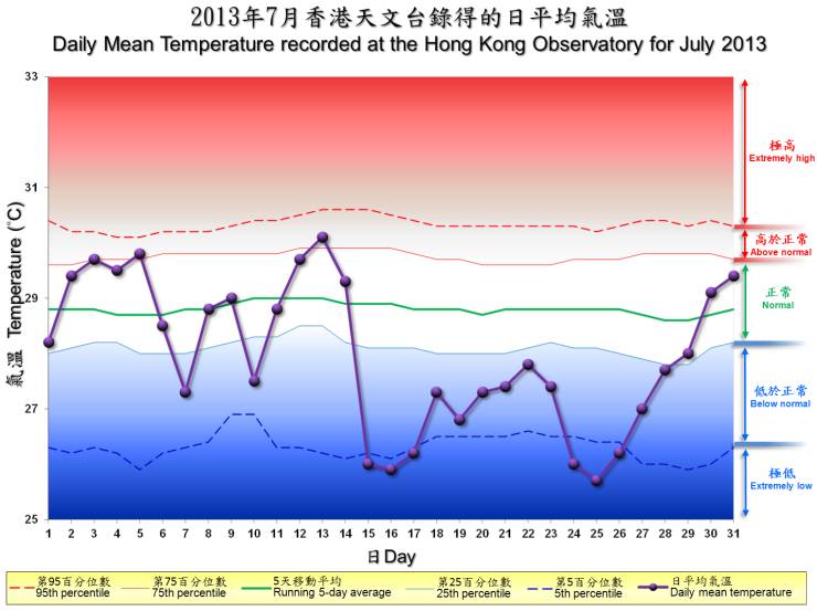
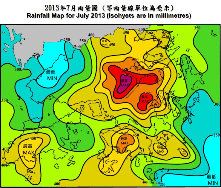
Under the influence of unsettled weather respectively associated with an active maritime airstream and a trough of low pressure over the South China Sea during the second half of the month, July 2013 was wetter than usual in Hong Kong. The total rainfall of the month was 436.3 millimetres, about 16 percent above the normal figure of 376.5 millimetres. The accumulated rainfall since 1 January was 1773.4 millimetres, about 20 percent above the normal figure of 1473.3 millimetres for the same period. The number of days with thunderstorms observed at the Hong Kong Observatory in the month was 14 days, the highest since 1995. The wet and cloudy weather also made July 2013 gloomier and cooler than usual. The total duration of bright sunshine was only 156.9 hours, about 26 percent below the normal figure of 212.0 hours. The mean temperature of the month was 28.0 degrees, 0.8 degree below the normal figure of 28.8 degrees. |
Warnings and Signals issued in July 2013
| Name of Tropical Cyclone |
Signal Number |
Beginning Time | Ending Time | ||
|---|---|---|---|---|---|
| Day/Month | HKT | Day/Month | HKT | ||
| RUMBIA | 1 | 30 / 6 | 2110 | 1 / 7 | 1315 |
| 3 | 1 / 7 | 1315 | 2 / 7 | 0510 | |
| 1 | 2 / 7 | 0510 | 2 / 7 | 0940 | |
| CIMARON | 1 | 17 / 7 | 2320 | 18 / 7 | 1540 |
| Beginning Time | Ending Time | ||
|---|---|---|---|
| Day/Month | HKT | Day/Month | HKT |
| 7 / 7 | 1610 | 7 / 7 | 1725 |
| Colour | Beginning Time | Ending Time | ||
|---|---|---|---|---|
| Day/Month | HKT | Day/Month | HKT | |
| Amber | 7 / 7 | 1605 | 7 / 7 | 1715 |
| Amber | 14 / 7 | 2335 | 15 / 7 | 0105 |
| Amber | 26 / 7 | 0800 | 26 / 7 | 1030 |
| Beginning Time | Ending Time | ||
|---|---|---|---|
| Day/Month | HKT | Day/Month | HKT |
| 1 / 7 | 0530 | 1 / 7 | 0700 |
| 1 / 7 | 1210 | 1 / 7 | 1900 |
| 6 / 7 | 1550 | 6 / 7 | 1730 |
| 7 / 7 | 0435 | 7 / 7 | 0630 |
| 7 / 7 | 0735 | 7 / 7 | 0845 |
| 7 / 7 | 1420 | 7 / 7 | 1800 |
| 8 / 7 | 0330 | 8 / 7 | 0530 |
| 9 / 7 | 0615 | 9 / 7 | 0945 |
| 9 / 7 | 1310 | 9 / 7 | 1645 |
| 9 / 7 | 1855 | 9 / 7 | 2230 |
| 10 / 7 | 0030 | 10 / 7 | 1230 |
| 10 / 7 | 1310 | 10 / 7 | 1700 |
| 10 / 7 | 2015 | 10 / 7 | 2230 |
| 11 / 7 | 0605 | 11 / 7 | 0715 |
| 11 / 7 | 1330 | 11 / 7 | 1530 |
| 12 / 7 | 1220 | 12 / 7 | 1400 |
| 14 / 7 | 0920 | 14 / 7 | 1200 |
| 14 / 7 | 1925 | 15 / 7 | 0200 |
| 15 / 7 | 0320 | 15 / 7 | 1700 |
| 16 / 7 | 0645 | 16 / 7 | 1400 |
| 17 / 7 | 1130 | 17 / 7 | 1530 |
| 17 / 7 | 1945 | 17 / 7 | 2145 |
| 19 / 7 | 1000 | 19 / 7 | 1200 |
| 19 / 7 | 1920 | 19 / 7 | 2230 |
| 20 / 7 | 0510 | 20 / 7 | 1430 |
| 20 / 7 | 1610 | 20 / 7 | 1730 |
| 21 / 7 | 1035 | 21 / 7 | 1130 |
| 21 / 7 | 1905 | 21 / 7 | 2100 |
| 22 / 7 | 1230 | 22 / 7 | 1330 |
| 22 / 7 | 1640 | 22 / 7 | 1845 |
| 23 / 7 | 1135 | 23 / 7 | 1830 |
| 24 / 7 | 0805 | 24 / 7 | 1400 |
| 24 / 7 | 1700 | 24 / 7 | 1930 |
| 25 / 7 | 0115 | 25 / 7 | 0300 |
| 25 / 7 | 0645 | 25 / 7 | 0745 |
| 25 / 7 | 1035 | 25 / 7 | 1145 |
| 25 / 7 | 1350 | 25 / 7 | 1530 |
| 25 / 7 | 2055 | 25 / 7 | 2230 |
| 25 / 7 | 2335 | 26 / 7 | 0230 |
| 26 / 7 | 0710 | 26 / 7 | 1130 |
| 27 / 7 | 0115 | 27 / 7 | 0415 |
| 27 / 7 | 1300 | 27 / 7 | 1600 |
| 28 / 7 | 0135 | 28 / 7 | 0245 |
| 28 / 7 | 0310 | 28 / 7 | 0500 |
| 28 / 7 | 1745 | 28 / 7 | 2300 |
| 29 / 7 | 1440 | 29 / 7 | 1615 |
| Beginning Time | Ending Time | ||
|---|---|---|---|
| Day/Month | HKT | Day/Month | HKT |
| 3 / 7 | 0745 | 5 / 7 | 1930 |
| 9 / 7 | 1330 | 9 / 7 | 1945 |
| 11 / 7 | 0745 | 13 / 7 | 1930 |
| 30 / 7 | 0745 | 31 / 7 | 1930 |
| Meteorological Element | Figure of the Month | Departure from Normal* |
|---|---|---|
| Mean Daily Maximum Air Temperature | 30.9 degrees C | 0.5 degree below normal |
| Mean Air Temperature | 28.0 degrees C | 0.8 degree below normal |
| Mean Daily Minimum Air Temperature | 26.1 degrees C | 0.7 degree below normal |
| Mean Dew Point Temperature | 25.1 degrees C | normal |
| Mean Relative Humidity | 85 % | 4 % above normal |
| Mean Cloud Amount | 72 % | 3 % above normal |
| Total Rainfall | 436.3 mm | 59.8 mm above normal |
| Number of hours of Reduced VisibilityΔ | 0 hour | 16.9 hours below normal§ |
| Total Bright Sunshine Duration | 156.9 hours | 55.1 hours below normal |
| Mean Daily Global Solar Radiation | 16.18 Megajoule / square metre | 0.99 Megajoule below normal |
| Total Evaporation | 131.0 mm | 15.2 mm below normal |
| Remarks : | All measurements were made at the Hong Kong Observatory except sunshine, solar radiation and evaporation which were recorded at King's Park Meteorological Station and visibility which was observed at the Hong Kong International Airport. |
| Δ |
The visibility readings at the Hong Kong International Airport are based on hourly observations by professional meteorological observers in 2004 and before, and average readings over the 10-minute period before the clock hour of the visibility meter near the middle of the south runway from 2005 onwards. The change of the data source in 2005 is an improvement of the visibility assessment using instrumented observations following the international trend. |
* Departure from 1981 - 2010 climatological normal, except for number of hours of reduced visibility |
|
§ Departure from mean value between 1997 and 2012 |
|


| Remarks : | Extremely high: above 95th percentile Above normal: between 75th and 95th percentile Normal: between 25th and 75th percentile Below normal: between 5th and 25th percentile Extremely low: below 5th percentile Percentile and 5-day running average values are computed based on the data from 1981 to 2010 |
