Skip Content

The Weather of May 2013

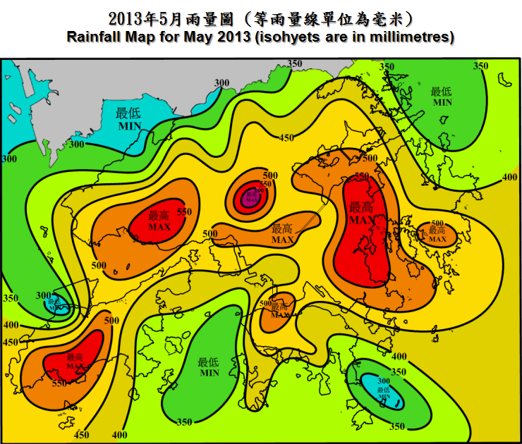
      May 2013 was much wetter and gloomier than usual due to the prolonged rainy weather associated with troughs of low pressure and active southwesterly airstream over the South China coastal areas. The total bright sunshine duration in the month was 90.7 hours, only about 65 percent of the normal. The total rainfall of May 2013 was 509.3 millimetres, about 67 percent above the normal figure of 304.7 millimetres. About 45 percent of the rainfall in the month was attributed to the rainstorm event on 22 May. The accumulated rainfall since 1 January was 898.5 millimetres, about 40 percent above the normal figure of 640.7 millimetres. 
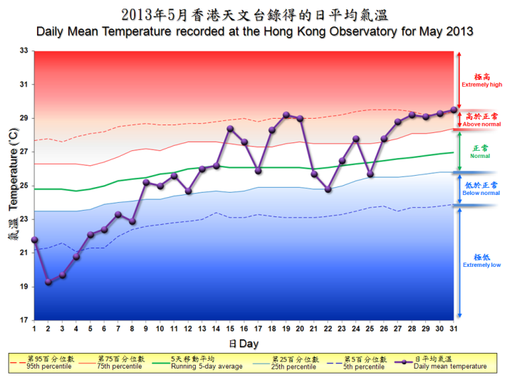
      While temperatures were significantly below normal during the first week of May 2013, the anomaly was offset by warmer-than-usual weather in the second half of the month. Overall, the mean temperature of the month was 25.7 degrees, just slightly below the normal figure of 25.9 degrees. 

      Under the influence of a fresh to strong easterly airstream, the weather in Hong Kong was mainly cloudy and windy with rain patches on the first day of the month. The arrival of an intense northeast monsoon brought cooler weather and a few rain patches to the territory the next day. Temperatures at the Observatory fell to a minimum of 16.6 degrees in that morning, the lowest in May since 1917. Under the combined effect of the northeast monsoon and a trough of low pressure over the northern part of the South China Sea, it was cloudy with persistent rain on 3 May. Rain was heavier over the western part of the New Territories with over 100 millimetres of rainfall in Tuen Mun, Kam Tin and Shek Kong. As the trough of low pressure weakened gradually over the next two days, the weather remained generally cloudy with rain patches. 

      Under the influence of a warm and humid easterly airstream, it was mainly cloudy with rain patches and coastal fog on 6 and 7 May. An area of rain and thunderstorms affected the Pearl River Estuary and the adjacent areas on the evening of 8 May and the small hours of 9 May, and brought heavy rain to the territory. The weather turned mainly fine during the day on 9 May. A trough of low pressure edged closer to the Pearl River Estuary that night, and local weather became cloudy with occasional rain and squally thunderstorms on 10 May. With the trough weakening slightly and moving to the northern part of the South China Sea, the weather improved gradually with a mixture of sunshine and showers on 11 and 12 May. There was also coastal fog on 12 May and the visibility at Waglan Island fell to about 100 metres that morning. 

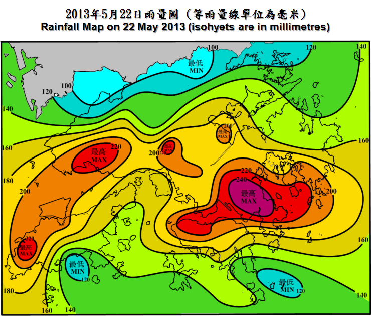
      With a humid maritime airstream prevailing over the South China coastal areas, it was generally cloudy with a few showers and coastal fog on 13 and 14 May in Hong Kong. The weather became hot with sunny intervals and a few showers on 15 May as local winds turned to southerlies. Affected by a trough of low pressure over the South China coastal areas, local weather deteriorated with heavy showers and squally thunderstorms from 16 to 18 May. With the trough shifting north, it was hot with sunny periods in Hong Kong on 19 May. The trough returned to the South China coastal areas on 20 May. Locally, while it was hot with sunny intervals during the day, there were heavy showers at night. With the trough lingering along the coast of Guangdong, the weather in Hong Kong remained unsettled on 21 and 22 May. A squall line swept across the Pearl River Estuary around noon on 21 May and brought heavy rain, thunderstorms and severe squalls to Hong Kong. Gusts exceeding 90 kilometres per hour were recorded in some parts of the territory. During the severe squalls, a gondola carrying two cleaners was smashed into a building in Wan Chai with one of the cleaners suffering injuries. In Tin Shui Wai, some stacked containers collapsed under the high winds, injuring one person. With a band of heavy rain spreading from west to east across the Pearl River Estuary, local weather deteriorated further with torrential rain and intense thunderstorms starting from the small hours of 22 May. The Hong Kong Observatory issued the Black Rainstorm Warning Signal at 4:10 a.m., the first time since July 2010. More than 150 millimetres of rain were recorded in many places over the territory. Rainfall recorded in Tseung Kwan O, eastern Kowloon, northern part of Hong Kong Island, Tuen Mun and Tung Chung even exceeded 200 millimetres. During the heavy downpour, there were 22 reports of landslip and 49 reports of flooding in Hong Kong. With the weakening of the trough of low pressure over the northern part of the South China Sea, the weather improved with sunny periods on 23 and 24 May. 

      The convergence of an active southwesterly airstream with an easterly airstream over the coast of Guangdong brought heavy showers and thunderstorms to Hong Kong again on the morning of 25 May. More than 40 millimetres of rainfall were generally recorded over the territory, whereas rainfall over parts of Lantau Island even exceeded 150 millimetres. An active southwesterly airstream maintained the showery weather in the next two days. As the southwesterly airstream subsided, local weather became hot with sunny periods and a few isolated showers on 28 and 29 May. The dominance of an anticyclone over southeastern China brought generally fine and hot weather to Hong Kong on 30 May. Temperatures at the Observatory on the last day of the month reached a maximum of 33.0 degrees, the highest for the month.   


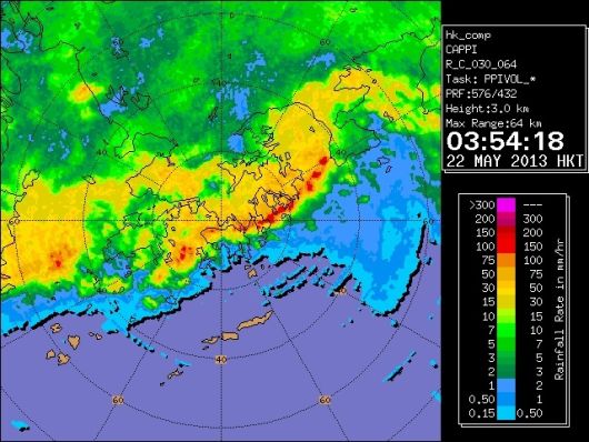
Radar on 22 may 2013 echoes showing that torrential rain and intense thunderstorms crossing the territory at 3:54am
Radar echoes showing that torrential rain and intense thunderstorms crossing the territory at 3:54am on 22 May 2013

Severe on 22 may 2013 landslide in sau mau ping
Severe landslide in Sau Mau Ping on 22 May 2013 (Photo Courtesy of Apple Daily)

     There was no tropical cyclone over the South China Sea and the western North Pacific in the month.

     Details of issuance and cancellation of various warnings/signals in the month are summarized in Tables 1.1 to 1.6.  Monthly meteorological figures and departures from normal for May are tabulated in Table 2.


Warnings and Signals issued in May 2013


Table 1.1   Strong Monsoon Signal

Beginning Time Ending Time
Day/Month HKT Day/Month HKT
1 / 5 2115 3 / 5 0445
8 / 5 2140 8 / 5 2330


Table 1.2   Rainstorm Warning Signals

Colour Beginning Time Ending Time
Day/Month HKT Day/Month HKT
Amber 8 / 5 2145 9 / 5 0130
Amber 16 / 5 1335 16 / 5 1520
Amber 20 / 5 2010 20 / 5 2120
Amber 21 / 5 1110 21 / 5 1230
Amber 22 / 5 0130 22 / 5 0320
Red 22 / 5 0320 22 / 5 0410
Black 22 / 5 0410 22 / 5 0945
Amber 22 / 5 0945 22 / 5 1030
Amber 25 / 5 1005 25 / 5 1225


Table 1.3   Landslip Warning

Beginning Time Ending Time
Day/Month HKT Day/Month HKT
22 / 5 0510 22 / 5 2200


Table 1.4   Thunderstorm Warning

Beginning Time Ending Time
Day/Month HKT Day/Month HKT
8 / 5 1630 9 / 5 0445
10 / 5 1010 10 / 5 1200
10 / 5 1320 10 / 5 1830
11 / 5 1730 11 / 5 1845
12 / 5 0720 12 / 5 0850
16 / 5 1220 16 / 5 1630
17 / 5 0655 17 / 5 1545
18 / 5 0205 18 / 5 0930
19 / 5 2100 19 / 5 2230
20 / 5 0345 20 / 5 0515
20 / 5 1145 20 / 5 1315
20 / 5 1350 20 / 5 1600
20 / 5 1850 20 / 5 2300
21 / 5 0245 21 / 5 1400
21 / 5 2100 22 / 5 1400
22 / 5 1535 22 / 5 1730
25 / 5 0215 25 / 5 1425
26 / 5 0235 26 / 5 1300
26 / 5 2120 27 / 5 0520
27 / 5 1030 27 / 5 1315
28 / 5 1200 28 / 5 1600
29 / 5 0145 29 / 5 0400
29 / 5 1045 29 / 5 1500
30 / 5 1135 30 / 5 1300


Table 1.5   Very Hot Weather Warning

Beginning Time Ending Time
Day/Month HKT Day/Month HKT
31 / 5 0645 3 / 6 2015


Table 1.6   Special Announcement on Flooding
in the Northern New Territories

Beginning Time Ending Time
Day/Month HKT Day/Month HKT
22 / 5 0325 22 / 5 1030


Table 2   Figures and Departures from Normal - May 2013

Meteorological Element Figure of the Month Departure from Normal*
Mean Daily Maximum Air Temperature 28.2 degrees C 0.2 degree below normal
Mean Air Temperature 25.7 degrees C 0.2 degree below normal
Mean Daily Minimum Air Temperature 23.9 degrees C 0.2 degree below normal
Mean Dew Point Temperature 23.2 degrees C 0.6 degree above normal
Mean Relative Humidity 86 % 3 % above normal
Mean Cloud Amount 80 % 4 % above normal
Total Rainfall 509.3 mm 204.6 mm above normal
Number of hours of Reduced VisibilityΔ 25 hours 28.8 hours below normal§
Total Bright Sunshine Duration 90.7 hours 49.7 hours below normal
Mean Daily Global Solar Radiation 12.29 Megajoule / square metre 1.9 Megajoule below normal
Total Evaporation 95.1 mm 15.6 mm below normal


  Remarks : All measurements were made at the Hong Kong Observatory except sunshine, solar radiation and evaporation which were recorded at King's Park Meteorological Station and visibility which was observed at the Hong Kong International Airport.

  Δ

The visibility readings at the Hong Kong International Airport are based on hourly observations by professional meteorological observers in 2004 and before, and average readings over the 10-minute period before the clock hour of the visibility meter near the middle of the south runway from 2005 onwards. The change of the data source in 2005 is an improvement of the visibility assessment using instrumented observations following the international trend.
Before 10 October 2007, the number of hours of reduced visibility at the Hong Kong International Airport in 2005 and thereafter displayed in this web page was based on hourly visibility observations by professional meteorological observers. Since 10 October 2007, the data have been revised using the average visibility readings over the 10-minute period before the clock hour, as recorded by the visibility meter near the middle of the south runway.


  *   Departure from 1981 - 2010 climatological normal, except for number of hours of reduced visibility

  §   Departure from mean value between 1997 and 2012


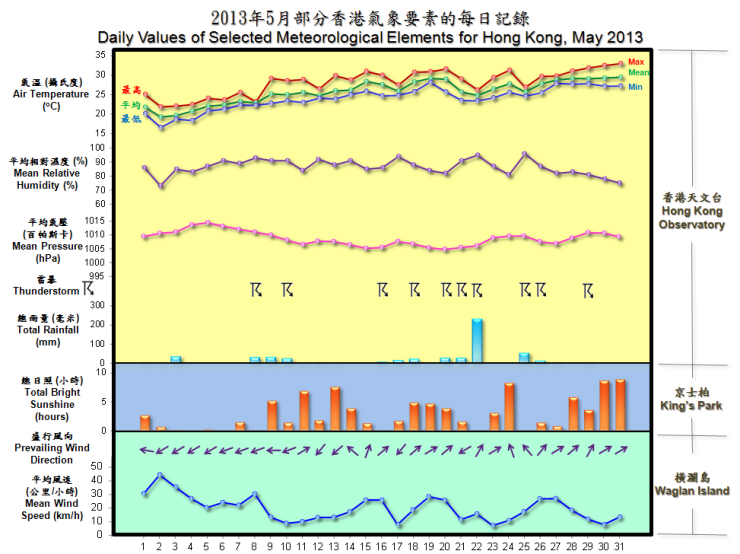
daily values of selected meteorological elements for HK for May 2013

The percentile map of mean temperature of May 2013

  Remarks : Extremely high: above 95th percentile
Above normal: between 75th and 95th percentile
Normal: between 25th and 75th percentile
Below normal: between 5th and 25th percentile
Extremely low: below 5th percentile
Percentile and 5-day running average values are
computed based on the data from 1981 to 2010