Skip Content

The Weather of April 2013


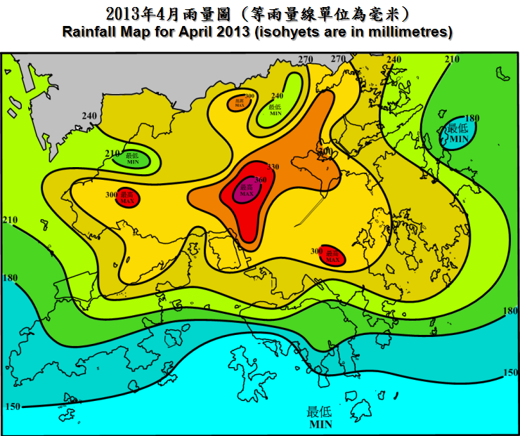
     April 2013 was marked by gloomy and unstable weather which were mainly attributed to the frequent interchange of the cooler northeast monsoon and the humid maritime airstream over the south China coast in the month.  The month was more thundery than usual with 8 thunderstorm days, about 4 days more than normal.  The sun only shone for 53.6 hours in the month, about 53 percent of the normal total duration of bright sunshine.  The total rainfall in the month was 253.8 millimetres, 79.1 millimetres above the normal amount.  The accumulated rainfall since the beginning of the year was 389.2 millimetres, about 16 percent above the normal figure of 336.0 millimetres. 
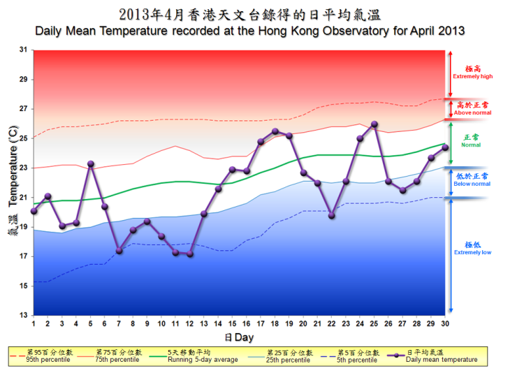
     With wetter and gloomier weather, April 2013 was also cooler than usual.  The mean temperature of the month was 21.5 degrees, 1.1 degrees below the normal figure of 22.6 degrees.

     Under the influence of the northeast monsoon, the weather in Hong Kong was cloudy with rain patches on the first day of the month.  It was cloudy with coastal fog in the morning on 2 April.  With the development of a trough of low pressure over the coastal areas of Guangdong, weather became unstable with occasional rain and a few squally thunderstorms during the day.  Affected by a fresh to strong easterly airstream, it was windy and misty with occasional rain the next day.  Local wind subsided gradually on 4 April but the weather remained rainy with fog patches.  There were also a few thunderstorms in the evening.

     An active southerly airstream brought heavy showers and squally thunderstorms to the territory in the morning on 5 April, bringing more than 50 millimetres of rainfall over Lantau Island and many places in the New Territories.  A cold front crossed the coastal areas of Guangdong in the small hours on 6 April.  Heavy showers and squally thunderstorms associated with the cold front affected Hong Kong during its passage.  The northeast monsoon behind the cold front brought windy and significantly cooler conditions to the territory during the day.  Temperatures over parts of the territory dropped by about 4 to 6 degrees comparing to those of the previous day.  Affected by the dry northerly airstream, it remained cool and dry on 7 April with the temperature at the Observatory dropping to 15.2 degrees in the morning, the lowest of the month.

     Under the influence of an easterly airstream over the coast of southeastern China, it was cloudy with rain patches on 8 April.  Affected by a rainband over the coast of Guangdong and its adjacent waters, there were occasional rain and a few thunderstorms the next day.  A replenishment of the northeast monsoon reached the coastal areas on the morning of 10 April and brought slightly cooler and rainy weather to Hong Kong from 10 to 12 April. 

     Affected by a dry continental airstream, local weather became mainly fine and dry on 13 April and the ensuing two days.  Under light wind condition, it was also hazy on 14 and 15 April with visibility falling below 3000 metres over parts of the territory.  A cloud band covered the coastal areas of Guangdong on 16 April.  Locally, the weather turned cloudy with coastal fog on that day.  Under the prevalence of a humid southerly airstream, it was foggy with a few thundery showers from 17 to 19 April.  Visibility at Waglan Island occasionally fell to around 100 metres during these three days.

     An easterly airstream affecting the coast of southeastern China brought cloudy weather with a few showers to the territory on 20 April.  Meanwhile, a cold front formed over inland Guangdong in the afternoon and crossed the coastal areas at night.    Under the influence of the northeast monsoon behind the cold front, it was windy and slightly cooler with rain patches on 21 and 22 April.  There were also some coastal fog on the night of 22 April. 

     Dominated by a warm and humid maritime airstream, local weather became warm with coastal fog from 23 to 25 April.  The temperatures at the Observatory rose to a maximum of 30.6 degrees on 25 April, the highest of the month.  Meanwhile, the rain and squally thunderstorms associated with a trough of low pressure over inland Guangdong swept across Hong Kong that evening, bringing more than 30 millimetres of rainfall to Hong Kong Island, Kwun Tong and Tseung Kwan O. 

     A fresh to strong easterly airstream affected the southeastern China on 26 and 27 April.  Locally, it was windy with rain patches on these two days.  With the persistence of the easterlies, there were some mist and light rain on 28 April.  Affected by a maritime airstream, it was mainly cloudy with a few rain patches and coastal fog on 29 April.  While 30 April started off with sunny intervals and warm weather, a squall line associated with a southward moving trough of low pressure over Guangdong swept across Hong Kong in the afternoon, bringing thunderstorms, heavy rain and severe squalls to the territory.  Gusts exceeding 90 kilometres per hour were recorded in Tai Mei Tuk.  During the severe squalls, some of the stacked containers in Kwai Tsing Container Terminals collapsed, resulting in one injured.  Also, a six-storey-high scaffold collapsed in Kowloon City.

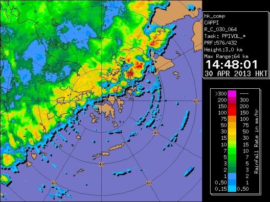
Radar echoes showing that a squall line was crossing the territory at 2:48pm on 30 April 2013.
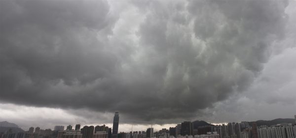

Fast moving squall line passing over Tsuen Wan in the afternoon on 30 April 2013.
Fast moving squall line passing over Tsuen Wan in the afternoon on 30 April 2013. (Photo courtesy of Ms. Christina Chan).

     There was no tropical cyclone over the South China Sea and the western North Pacific in the month.

     Details of issuance and cancellation of various warnings/signals in the month are summarized in Tables 1.1 to 1.4.  Monthly meteorological figures and departures from normal for April are tabulated in Table 2.


Warnings and Signals issued in April 2013


Table 1.1   Strong Monsoon Signal

Beginning Time Ending Time
Day/Month HKT Day/Month HKT
3 / 4 0615 3 / 4 1400
6 / 4 0720 6 / 4 1225
6 / 4 1930 7 / 4 0400
26 / 4 2030 27 / 4 0745


Table 1.2   Rainstorm Warning Signals

Colour Beginning Time Ending Time
Day/Month HKT Day/Month HKT
Amber 5 / 4 0840 5 / 4 1030
Amber 6 / 4 0000 6 / 4 0230
Amber 25 / 4 1930 25 / 4 2100
Amber 30 / 4 1420 30 / 4 1615


Table 1.3   Thunderstorm Warning

Beginning Time Ending Time
Day/Month HKT Day/Month HKT
2 / 4 1215 2 / 4 1715
4 / 4 1740 4 / 4 1900
5 / 4 0130 5 / 4 0530
5 / 4 0705 5 / 4 1030
5 / 4 2320 6 / 4 0300
9 / 4 0747 9 / 4 0915
9 / 4 1131 9 / 4 1245
9 / 4 1930 10 / 4 0600
10 / 4 1615 10 / 4 1745
12 / 4 0335 12 / 4 0430
17 / 4 1115 17 / 4 1730
18 / 4 1420 18 / 4 1930
19 / 4 0225 19 / 4 0600
19 / 4 1615 19 / 4 2145
20 / 4 2200 21 / 4 0200
25 / 4 1830 25 / 4 2200
30 / 4 1400 30 / 4 1800


Table 1.4   Fire Danger Warnings

Colour Beginning Time Ending Time
Day/Month HKT Day/Month HKT
Yellow 7 / 4 0600 7 / 4 1800
Yellow 13 / 4 0600 13 / 4 1800
Yellow 14 / 4 0630 14 / 4 2030


Table 2   Figures and Departures from Normal - April 2013

Meteorological Element Figure of the Month Departure from Normal*
Mean Daily Maximum Air Temperature 23.9 degrees C 1.1 degrees below normal
Mean Air Temperature 21.5 degrees C 1.1 degrees below normal
Mean Daily Minimum Air Temperature 19.7 degrees C 1.1 degrees below normal
Mean Dew Point Temperature 19.0 degrees C 0.4 degree below normal
Mean Relative Humidity 86 % 3 % above normal
Mean Cloud Amount 81 % normal
Total Rainfall 253.8 mm 79.1 mm above normal
Number of hours of Reduced VisibilityΔ 98 hours 2.2 hours above normal§
Total Bright Sunshine Duration 53.6 hours 48.1 hours below normal
Mean Daily Global Solar Radiation 8.98 Megajoule / square metre 2.62 Megajoule below normal
Total Evaporation 64.6 mm 19.2 mm below normal


  Remarks : All measurements were made at the Hong Kong Observatory except sunshine, solar radiation and evaporation which were recorded at King's Park Meteorological Station and visibility which was observed at the Hong Kong International Airport.

  Δ

The visibility readings at the Hong Kong International Airport are based on hourly observations by professional meteorological observers in 2004 and before, and average readings over the 10-minute period before the clock hour of the visibility meter near the middle of the south runway from 2005 onwards. The change of the data source in 2005 is an improvement of the visibility assessment using instrumented observations following the international trend.
Before 10 October 2007, the number of hours of reduced visibility at the Hong Kong International Airport in 2005 and thereafter displayed in this web page was based on hourly visibility observations by professional meteorological observers. Since 10 October 2007, the data have been revised using the average visibility readings over the 10-minute period before the clock hour, as recorded by the visibility meter near the middle of the south runway.


  *   Departure from 1981 - 2010 climatological normal, except for number of hours of reduced visibility

  §   Departure from mean value between 1997 and 2012

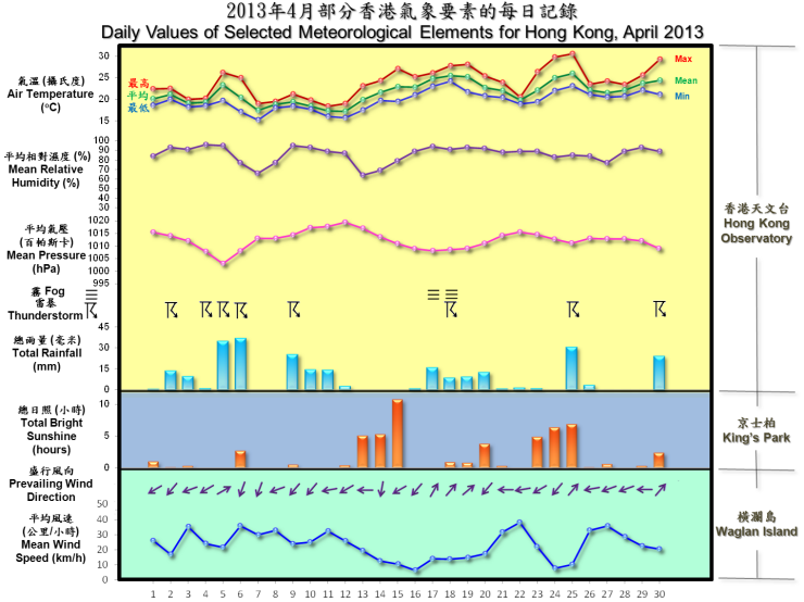
daily values of selected meteorological elements for HK for April 2013

The percentile map of mean temperature of April 2013

  Remarks : Extremely high: above 95th percentile
Above normal: between 75th and 95th percentile
Normal: between 25th and 75th percentile
Below normal: between 5th and 25th percentile
Extremely low: below 5th percentile
Percentile and 5-day running average values are
computed based on the data from 1981 to 2010