|
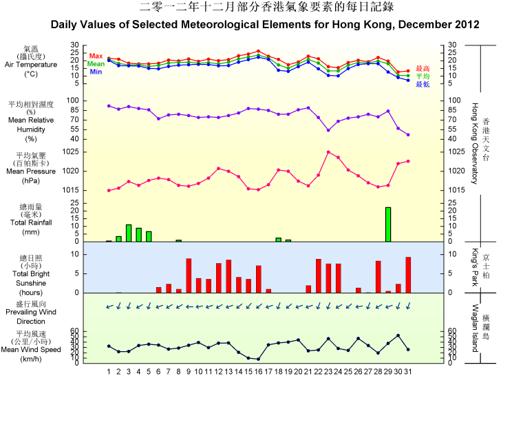
Affected by rain-bearing cloud band associated with the northeast monsoon during the first and last part of the month, December 2012 was gloomier and wetter than usual. The total duration of bright sunshine in the month was 101.0 hours, 41 percent below the normal figure of 172.2 hours and ranking the fifth lowest on record for December. The monthly total rainfall was 56.0 millimetres, more than double the normal figure of 26.8 millimetres. The annual rainfall for 2012 was 1924.7 millimetres, a deficit of about 20 percent compared with the annual normal of 2398.4 millimetres. Overall, the monthly mean temperature was close to normal, being 0.1 degree lower than the normal figure of 17.9 degrees.
Under the influence of the northeast monsoon, accompanied by rain-bearing clouds, the weather in Hong Kong was generally cloudy with rain patches for the first eight days of the month. Affected by a dry continental airstream, it turned mainly fine and dry on 9 and 10 December. A weak cold front over northern Guangdong moved across the coast on 11 December, bringing some haze to Hong Kong. With the prevalence of the associated northeast monsoon, it remained generally fine and sunny for the next two days.
Affected by a maritime airstream, it was mainly cloudy and warmer with low visibility over parts of the territory from 14 to 17 December. Fog was reported at Waglan Island with visibility fell below 200 metres on the mornings of 16 and 17 December. An intense cold front crossed the coastal areas of Guangdong on the morning of 18 December. Local weather turned cloudy with rain patches and significantly cooler with temperatures generally dropping below 15 degrees that afternoon. The strong northerly winds behind the cold front brought generally cold weather to Hong Kong the next day.
With the setting in of a fresh to strong easterly airstream over the coastal areas of Guangdong, it was cloudy and windy with relatively low visibility on 20 December. The easterly airstream moderated gradually on 21 December and there were some sunny intervals in the afternoon.
Another cold front crossed the coast of Guangdong on the morning of 22 December. Local weather was cloudy with mist in the morning and became mainly fine in the afternoon. Northerly winds strengthened overnight with temperatures falling significantly, by generally 6 to 8 degrees as compared with those of the previous night. Dominated by the winter monsoon, the weather remained cold and dry for the next two days. It began to gradually warm up with cloudy and generally cool condition on Christmas Day.
Affected by a fresh to strong easterly airstream, the weather was windy and dry with sunny intervals on 26 December. The easterlies moderated gradually on the next day but a broad band of cloud covered southern China, bringing a few rain patches to the territory. The weather became mainly fine on 28 December as the cloud band moved eastwards. Meanwhile, a cold front formed over northeast China and edged southwards on 29 December. With the approach of the cold front, local weather was cloudy with occasional rain on that day. As the cold front moved across the territory that evening, winds strengthened from the north and temperatures dropped significantly overnight from about 19 degrees to 9 degrees at the Observatory in the next morning. Dominated by the intense winter monsoon behind the cold front, the weather was cold and dry on 30 December. The temperature dropped further on the last day of the month, lowering to a minimum of 7.1 degrees at the Observatory, making this the third coldest New Years Eve on record.
|

