|
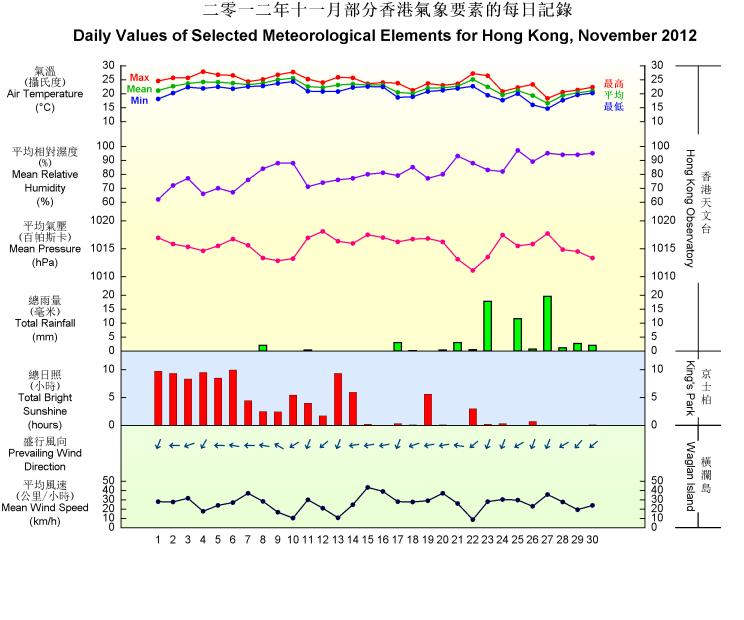
November 2012 in Hong Kong was marked by gloomy and humid weather particularly in the latter part of the month, as a result of the frequent interchange between cool northeast monsoon and warm and humid maritime airstream over the south China coastal areas. The total duration of bright sunshine captured in the month was 101.4 hours, a record low for November since 1885. The monthly mean relative humidity was 81 percent, tying with that of 1960 as the highest record for November.
November 2012 was also warmer and wetter than usual in Hong Kong. The monthly mean temperature was 22.2 degrees, 0.4 degrees higher than the normal figure of 21.8 degrees. The monthly total rainfall was 63.9 millimetres, about 70 percent more than the normal figure of 37.6 millimetres. In spite of that, the accumulated rainfall of 1868.7 millimetres since 1 January was still 21 percent below the normal figure of 2371.6 millimetres for the same period.
Under the influence of a dry northeast monsoon, the weather in Hong Kong was sunny and dry for the first six days of the month. A broad cloud band over southern China brought mainly cloudy weather with a few rain patches to the territory on 7 and 8 November. Affected by a warm and humid maritime airstream, it was warm with some mist on the next two days.
Meanwhile, a cold front formed over the northern part of southern China and moved southwards steadily on 10 November. It crossed the coast of Guangdong the next morning. The associated northeast monsoon brought mainly cloudy and cooler weather to Hong Kong on 11 and 12 November. After the clouds thinned out, it was generally fine on 13 and 14 November. With the winds strengthening from the east, it was windy and cloudy with a few light rain patches on 15 and 16 November.
Another cold front formed over the northern part of southern China on 16 November and crossed the coastal areas of Guangdong the next day. Affected by the northeast monsoon behind the cold front, local weather became cooler with rain patches on 17 and 18 November. With clouds thinning out gradually, there were sunny periods on 19 November. Under the influence of a moderate to fresh easterly airstream, the weather in Hong Kong turned cloudy with rain patches again the next day.
With the setting in of a warm and humid southeasterly airstream, it was humid with rain and coastal fog patches on 21 and 22 November. Meanwhile, a cold front formed over the northern part of southern China during the night of 22 November and moved across the coast of Guangdong the next morning. The passage of the cold front over the territory was accompanied by a few thunderstorms and a significant drop in temperature. Local temperatures in the afternoon on 23 November were generally 6 to 7 degrees lower than those of the previous day. The weather remained cloudy and cool with a few rain patches on 24 November.
The humid maritime airstream returned to the coastal areas of Guangdong on 25 November, bringing overcast weather with mist and occasional rain to Hong Kong. Another cold front crossed the coastal areas of Guangdong on the morning of 26 November. During the passage of the cold front, local weather became appreciably cooler and there were also some coastal fog. The visibility at Waglan Island once fell to around 100 metres in that morning. Under the influence of the intense northeast monsoon behind the cold front and a broad rain bearing cloud band over southern China, it was gloomy, rainy and cool in Hong Kong on 27 November. The temperature at the Observatory fell to a minimum of 14.6 degrees on the morning of 27 November, the lowest of the month. The northeast monsoon moderated and the weather remained cloudy with rain patches for the last three days of the month.
|

