The Weather of July 2012
|
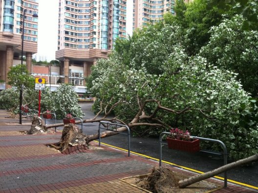
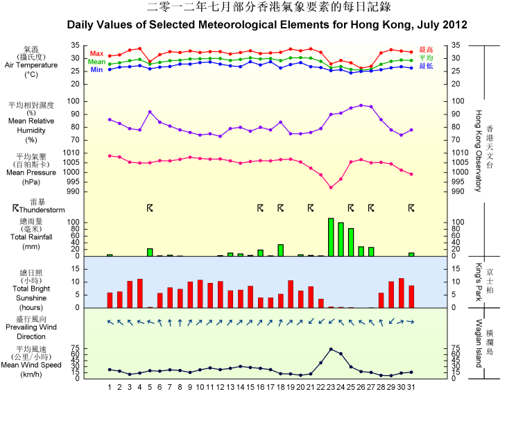
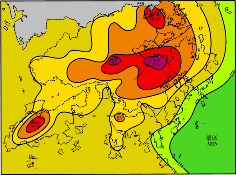
Under the general prevalence of the subtropical ridge of high pressure, the weather of the first half of July 2012 was drier and warmer than usual. However, the rainfall deficit was more than compensated by the heavy rain episodes in the latter part of the month respectively brought about by the southwest monsoon and Severe Typhoon Vicente. Overall, the monthly total rainfall was 467.8 millimetres, about 24 percent above the normal. The accumulated rainfall since 1 January was 1395.6 millimetres, about 5 percent below the normal figure of 1473.3 millimetres for the same period. The mean temperature and relative humidity of the whole month are both near-normal. Under the influence of the subtropical ridge, the weather in Hong Kong was mainly fine and hot apart from a few showers for the first two days of the month. With winds turning light, it was sunny and very hot during the day on 3 and 4 July. The temperature at the Observatory rose to a maximum of 33.8 degrees on 4 July, the highest in the month.  Trees blown down near Olympian City during the strike of Severe Typhoon Vicente (Photo courtesy of Ms. Carly Tse) |
|
Four tropical cyclones occurred over the western North Pacific and the South China Sea in the month. |
|
Details of issuance and cancellation of various warnings/signals in the month are summarized in Tables 1.1 to 1.7. Monthly meteorological figures and departures from normal for July are tabulated in Table 2. |
Warnings and Signals issued in July 2012
| Name of Tropical Cyclone |
Signal Number |
Beginning Time | Ending Time | ||
|---|---|---|---|---|---|
| Day/Month | HKT | Day/Month | HKT | ||
| VICENTE | 1 | 21 / 7 | 1540 | 23 / 7 | 0520 |
| 3 | 23 / 7 | 0520 | 23 / 7 | 1740 | |
| 8 NE | 23 / 7 | 1740 | 23 / 7 | 2320 | |
| 9 | 23 / 7 | 2320 | 24 / 7 | 0045 | |
| 10 | 24 / 7 | 0045 | 24 / 7 | 0335 | |
| 8 SE | 24 / 7 | 0335 | 24 / 7 | 1010 | |
| 3 | 24 / 7 | 1010 | 24 / 7 | 1440 | |
| 1 | 24 / 7 | 1440 | 24 / 7 | 2315 | |
| Beginning Time | Ending Time | ||
|---|---|---|---|
| Day/Month | HKT | Day/Month | HKT |
| 24 / 7 | 2316 | 25 / 7 | 0520 |
| Colour | Beginning Time | Ending Time | ||
|---|---|---|---|---|
| Day/Month | HKT | Day/Month | HKT | |
| Amber | 5 / 7 | 0920 | 5 / 7 | 1020 |
| Amber | 18 / 7 | 0610 | 18 / 7 | 0820 |
| Amber | 21 / 7 | 1735 | 21 / 7 | 1840 |
| Amber | 24 / 7 | 0155 | 24 / 7 | 1040 |
| Amber | 25 / 7 | 1130 | 25 / 7 | 1420 |
| Amber | 27 / 7 | 1100 | 27 / 7 | 1230 |
| Amber | 31 / 7 | 1710 | 31 / 7 | 1835 |
| Beginning Time | Ending Time | ||
|---|---|---|---|
| Day/Month | HKT | Day/Month | HKT |
| 24 / 7 | 0110 | 24 / 7 | 1500 |
| Beginning Time | Ending Time | ||
|---|---|---|---|
| Day/Month | HKT | Day/Month | HKT |
| 5 / 7 | 0250 | 5 / 7 | 0400 |
| 5 / 7 | 0425 | 5 / 7 | 0630 |
| 5 / 7 | 0725 | 5 / 7 | 1600 |
| 8 / 7 | 1232 | 8 / 7 | 1445 |
| 14 / 7 | 0455 | 14 / 7 | 0600 |
| 14 / 7 | 0720 | 14 / 7 | 0930 |
| 16 / 7 | 1140 | 16 / 7 | 1245 |
| 16 / 7 | 1900 | 16 / 7 | 2245 |
| 17 / 7 | 0625 | 17 / 7 | 0730 |
| 18 / 7 | 0130 | 18 / 7 | 1100 |
| 18 / 7 | 1245 | 18 / 7 | 1400 |
| 18 / 7 | 1945 | 18 / 7 | 2030 |
| 19 / 7 | 0225 | 19 / 7 | 0745 |
| 19 / 7 | 1355 | 19 / 7 | 1500 |
| 20 / 7 | 0705 | 20 / 7 | 0745 |
| 20 / 7 | 1430 | 20 / 7 | 1530 |
| 21 / 7 | 1445 | 21 / 7 | 1915 |
| 21 / 7 | 2125 | 21 / 7 | 2400 |
| 22 / 7 | 1135 | 22 / 7 | 1700 |
| 24 / 7 | 0015 | 24 / 7 | 0515 |
| 25 / 7 | 0420 | 25 / 7 | 0830 |
| 25 / 7 | 1030 | 25 / 7 | 1530 |
| 25 / 7 | 1755 | 25 / 7 | 2030 |
| 26 / 7 | 0845 | 26 / 7 | 1530 |
| 27 / 7 | 0400 | 27 / 7 | 1700 |
| 28 / 7 | 1100 | 28 / 7 | 1330 |
| 31 / 7 | 1605 | 31 / 7 | 1850 |
| Beginning Time | Ending Time | ||
|---|---|---|---|
| Day/Month | HKT | Day/Month | HKT |
| 3 / 7 | 1345 | 4 / 7 | 1945 |
| 7 / 7 | 1455 | 12 / 7 | 1945 |
| 15 / 7 | 0915 | 15 / 7 | 1945 |
| 16 / 7 | 0745 | 16 / 7 | 1745 |
| 19 / 7 | 0745 | 21 / 7 | 1945 |
| 29 / 7 | 1505 | 31 / 7 | 1710 |
| Beginning Time | Ending Time | ||
|---|---|---|---|
| Day/Month | HKT | Day/Month | HKT |
| 24 / 7 | 0155 | 24 / 7 | 1225 |
| 25 / 7 | 1300 | 25 / 7 | 1845 |
| Meteorological Element | Figure of the Month | Departure from Normal* |
|---|---|---|
| Mean Daily Maximum Air Temperature | 31.6 degrees C | 0.2 degree above normal |
| Mean Air Temperature | 28.8 degrees C | normal |
| Mean Daily Minimum Air Temperature | 26.8 degrees C | normal |
| Mean Dew Point Temperature | 25.2 degrees C | 0.1 degree above normal |
| Mean Relative Humidity | 81 % | normal |
| Mean Cloud Amount | 70 % | 1 % above normal |
| Total Rainfall | 467.8 mm | 91.3 mm above normal |
| Number of hours of Reduced VisibilityΔ | 7 hours | 10.5 hours below normal§ |
| Total Bright Sunshine Duration | 197.6 hours | 14.4 hours below normal |
| Mean Daily Global Solar Radiation | 18.14 Megajoule / square metre | 0.97 Megajoule above normal |
| Total Evaporation | 154.7 mm | 8.5 mm above normal |
| Remarks : | All measurements were made at the Hong Kong Observatory except sunshine, solar radiation and evaporation which were recorded at King's Park Meteorological Station and visibility which was observed at the Hong Kong International Airport. |
| Δ |
The visibility readings at the Hong Kong International Airport are based on hourly observations by professional meteorological observers in 2004 and before, and average readings over the 10-minute period before the clock hour of the visibility meter near the middle of the south runway from 2005 onwards. The change of the data source in 2005 is an improvement of the visibility assessment using instrumented observations following the international trend. |
* Departure from 1981 - 2010 climatological normal, except for number of hours of reduced visibility |
|
§ Departure from mean value between 1997 and 2011 |
|

