|
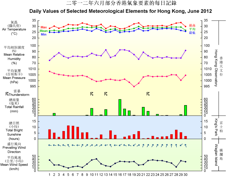
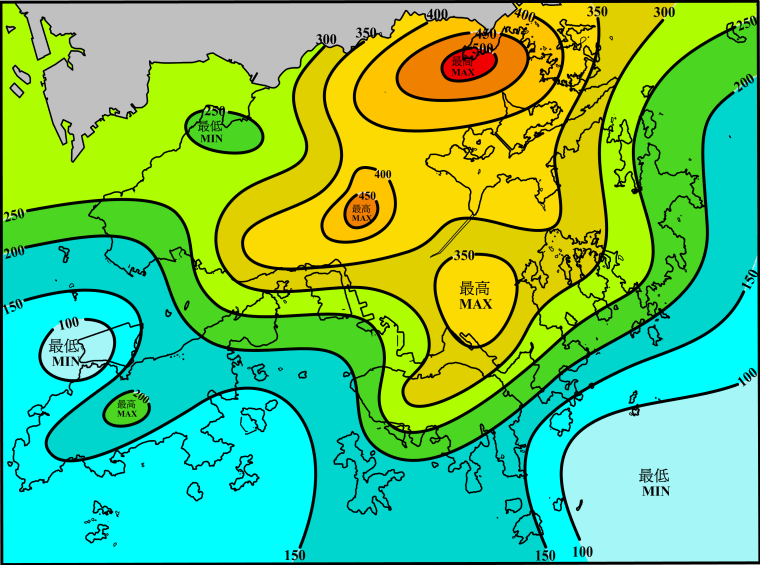
June 2012 was drier than usual, especially in the first half of the month. This was mainly attributed to the predominance of the ridge of high pressure and the lack of active trough of low pressure over the south China coastal areas during the early part of the month. The total rainfall of the month was 261.5 millimetres, about 43 percent below the normal figure of 456.1 millimetres. The accumulated rainfall since 1 January was 927.8 millimetres, a deficit of 15 percent comparing to the normal figure of 1096.8 millimetres for the same period. The month was also slightly warmer than usual with the mean temperature of 28.1 degrees, 0.2 degrees above the normal figure of 27.9 degrees.
Under the influence of a ridge of high pressure, the weather in Hong Kong was generally fine apart from a few showers for the first four days in the month. It remained fine and hot with moderate easterly winds from 5 to 7 June. As winds turned southerly, it became very hot apart from a few showers on 8 June.
With the establishment of the fresh to strong southwest monsoon, the weather gradually became cloudy with showers and a few squally thunderstorms for the next three days. Meanwhile, a trough of low pressure over inland Guangdong moved southwards and lingered over the coast on 12 and 13 June, bringing a few thundery showers to the territory on these two days. With the trough of low pressure moving into the northern part of the South China Sea, local weather improved and there were sunny periods on 14 and 15 June.
The trough of low pressure deepened over the northern part of the South China Sea and brought more than 50 millimetres of rainfall over most parts of the territory on 16 June. An area of low pressure developed over the sea to the east of Hainan Island and intensified into a tropical depression on 17 June. While moving eastwards across the northern part of the South China Sea, it further intensified into a tropical storm, named Talim, in the next morning and finally became a severe tropical storm that night. Affected by the passage of Talim to the south, there were some squally showers and occasional strong winds offshore and on high ground in Hong Kong on 17 and 18 June.
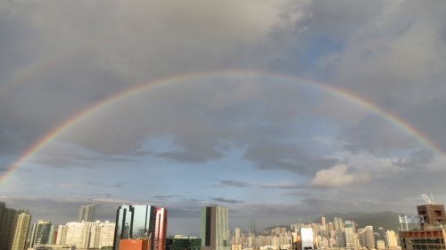
With Talim gradually moving away, local weather improved with sunny periods on 19 June. The sun rays in concert with the departing rain clouds also gave rise to a prominent double rainbow over Hong Kong later in that afternoon. While Talim continued to track northeast towards the Taiwan Strait, local winds turned northerly on 20 June. The northerly continental airstream brought very hot weather to Hong Kong on that day. Affected by the active southwest monsoon, local weather turned cloudy with showers and a few squally thunderstorms on the next two days. As the moisture associated the active southwest monsoon moved inland, there were sunny intervals and a few showers from 23 to 26 June. Affected by a ridge of high pressure extending westwards from the Pacific, the weather became generally fine and hot on 27 and 28 June.
Meanwhile, Tropical Storm Doksuri over the seas east of the Philippines moved across the Luzon Strait on 28 June and edged towards the coast of Guangdong the next day. Under the influence of the subsidence air ahead of Doksuri, it was very hot on 29 June. The temperature recorded at the Observatory soared to a maximum of 33.3 degrees in that afternoon, the highest of the month. As Doksuri came close to the Pearl River Estuary, local winds strengthened with squally showers that evening. Gale force winds were recorded in some parts of Hong Kong at night on 29 June and on the early morning of 30 June.
Doksuri made landfall to the west of the Pearl River Estuary and weakened over the inland area of western Guangdong on the morning of 30 June. Locally, winds subsided gradually but, due to the remnant rainbands of Doksuri on that day, there were still scattered showers and a few squally thunderstorms in Hong Kong.

A double rainbow appeared over Hong Kong in the afternoon on 19 June 2012
|


