|
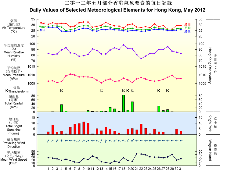
May 2012 was warmer than usual. The mean temperature of the month was 27.0 degrees, 1.1 degrees above the normal figure of 25.9 degrees. The early part of the month was exceptionally warm. With the prevalence of warm maritime airstream together with abundant sunshine, the mean temperature rose to 27.7 degrees during 1 to 15 May and tied with that of 1977 as the highest in the first half of May since record began. Moreover, the lowest temperature of the month as recorded on 5 May was 24.1 degrees, the highest absolute minimum temperature for May on record.
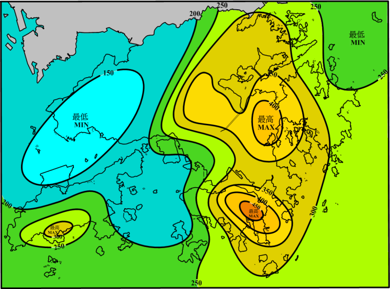
The monthly total rainfall was 277.7 millimetres, about 9 percent below normal. About 70 percent of the monthly total rainfall was associated with the heavy rain episodes in the latter half of May. The accumulated rainfall since 1 January was 666.3 millimetres, slightly above the normal figure of 640.7 millimetres for the same period.
Under the influence of a warm southerly airstream, the weather in Hong Kong was mainly fine and hot for the first three days of the month, apart from a few showers in the morning. The minimum temperature recorded at the Hong Kong Observatory reached 28.0 degrees on 3 May, the earliest occurrence of 'Hot Night' * since record began. On 4 May, an intense thunderstorm developed over inland Guangdong and moved southwards across Hong Kong at night, bringing more than 100 millimetres of rainfall over the eastern part of Hong Kong Island and the southern part of Lantau Island. Affected by an easterly airstream, the weather was slightly cooler with some rain on 5 May. With the cloud thinning out, there were sunny internals on the next day.
Dominated by a ridge of high pressure, the weather became generally fine from 7 to 10 May. With plenty of sunshine, the maximum temperature at the Observatory rose to 32.5 degrees both on 9 and 10 May, the highest of the month. However, in the evening on 10 May, an area of thunderstorms moved across the coastal areas of Guangdong and brought more than 30 millimetres of rainfall to the eastern part of the New Territories. With the setting in of an easterly airstream, it was cloudy with some rain and a few squally thunderstorms on 11 and 12 May.
A trough of low pressure lingered over the coastal areas of Guangdong and brought occasionally heavy showers and squally thunderstorms to the territory for the ensuing eight days. Rain was particularly heavy in the morning on 18 May with more than 50 millimetres of rainfall recorded over many places in Hong Kong and over 100 millimetres in Sai Kung. The heavy thundery showers in the afternoon and the evening on 20 May brought more than 70 millimetres over the northwestern part of Hong Kong Island and parts of the northern New Territories.
With the establishment of a ridge of high pressure over southeastern China, local weather improved gradually and it became generally fine and windy from 21 to 23 May. As the ridge weakened, local weather was generally cloudy with a few rain patches on 24 May. The weather improved with sunny periods on 25 May and the maximum temperature rose to over 30 degrees in most parts of the territory. With the trough of low pressure over the northern part of the South China Sea edging closer to the coast, the weather was cloudy with a few squally thunderstorms for the next three days. The rain was particularly heavy on the morning of 28 May. Over 100 millimetres of rainfall was recorded in northern part of the New Territories. Under the influence of a fresh to strong easterly airstream, it was windy with a few rain patches on 29 May. With the weakening of the easterly airstream, there were sunny intervals the next day. The easterlies strengthened again over the coast of southeastern China on the last day of the month, bringing mainly cloudy weather with a few showers to Hong Kong.
* 'Hot Night' refers to the condition with the daily minimum temperature equal to or higher than 28.0 degrees
|

