|
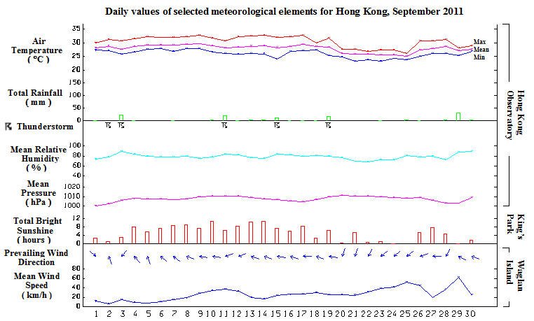
In spite of a major tropical cyclone affecting Hong Kong during September 2011, the total rainfall recorded for the month was only 123.1 millimetres or 43 percent of the normal figure. The accumulated rainfall since 1 January of 1225.9 millimetres still suffers a deficit of 43 percent compared to the normal figure of 2161.2 millimetres for the same period. The month was also warmer than usual with a monthly mean temperature of 28.0 degrees which was 0.4 degrees above normal.
Under the influence of the remnants of tropical cyclone Nanmadol, local weather was mainly cloudy with a few showers for the first day of the month. Affected by a trough of low pressure, there were showers and a few squally thunderstorms on 2 and 3 September. With the dissipation of the trough of low pressure, the weather became generally fine for the ensuing seven days.
Another trough of low pressure developed over the northern part of the South China Sea and brought mainly cloudy conditions with showers to the territory on 11 and 12 September. This trough of low pressure gave way to a weak ridge of high pressure and local weather was mainly fine and dry for the next two days apart from isolated showers in the morning .
The weather turned unstable during the morning of 15 September and there were showers and thunderstorms in Hong Kong. Fine weather resumed during the day and persisted in the next two days except for some isolated showers. Under the influence of a moderate to fresh easterly airstream and a low pressure area to the south, the territory experienced cloudy weather with showers mainly in its southern part on 18 September.
On 19 September, a cold front formed over southern China in the afternoon and crossed the coast of Guangdong that evening. This first passage of a cold front since the summer was accompanied by thundery showers and local temperatures dropped significantly from a maximum of about 32 degrees during the afternoon in the urban areas to around 25 degrees in the evening. The northeast monsoon behind the cold front brought cooler and mainly cloudy weather with a few rain patches to the territory for the ensuing five days.
An area of low pressure over the northern part of the South China Sea intensified into a tropical storm and was named Haitang on 25 September. While it moved across the seas south of Hainan, the combined effect of the northeast monsoon and Haitang brought windy weather with a few rain patches to Hong Kong from 25 to 26 September. Local winds moderated on the following day as Haitang weakened near the coast of Vietnam.
Meanwhile, Typhoon Nesat developed over the western North Pacific on 23 September. It crossed Luzon and entered the South China Sea on 27 September. Nesat moved generally west-northwestwards across the northern part of the South China Sea for the next two day and made landfall over Hainan Island in the afternoon on 29 September, entering Beibu Wan in the late evening. Under the influence of Nesat, squally showers affected Hong Kong and local winds strengthened gradually on 28 September. As Nesat edged closer on 29 September, there were strong to gale east to southeasterly winds with squally showers. The maximum peak gust recorded at Cheung Chau reached 121 kilometres per hours that morning. With Nesat weakening into a tropical storm and moving further away from Hong Kong on 30 September, local winds subsided gradually and the weather was mainly cloudy with a few showers.
|
