Skip Content

The Weather of August 2011 - One of the hottest August on record

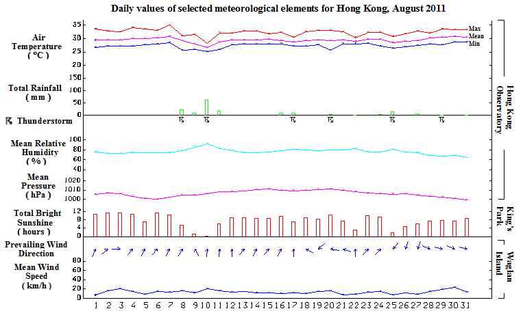
     Under the prolonged dominance of the sub-tropical ridge, Hong Kong experienced one of the hottest August since records began in 1884.  The monthly mean temperature soared to 29.5 degrees, equaling the record set in 1990 and 1998 and was 1.1 degrees above normal.  The month was sunnier than usual.  The monthly total duration of bright sunshine was 242.0 hours, 52.3 hours higher than normal.  The month was also dry with a total rainfall of 157.6 millimetres, only 35 percent of the normal figure and the accumulated rainfall since 1 January of 1102.8 millimetres suffered a deficit of 41 percent compared to the normal figure of 1873.7 millimetres for the same period.

     Under the influence of a persistent anticyclone aloft, the weather in Hong Kong was sunny and very hot for first seven days of the month.  The temperatures at the Hong Kong Observatory rose to a maximum of 35.0 degrees in the afternoon on 7 August, the highest of the month.  

     A trough of low pressure developed near the South China coast and  brought thundery showers to the territory for the next two days.  As the trough of low pressure became more active, there were occasional heavy rain and squally thunderstorms over the territory on 10 August.  With the weakening of the trough of low pressure on 11 August, the rain eased off and there were sunny periods during the day.  

     Dominated by a ridge of high pressure over southern China, local weather became sunny and hot apart from a few showers from 12 to 16 August.  With a temporary retreat of the ridge, there were thunderstorms in the afternoon on 17 August.  As the ridge re-established over southern China, local weather became generally fine and very hot in the ensuing three days.  Despite the weakening of the ridge of high pressure, the weather was generally fine apart from a few showers and isolated thunderstorms from 21 to 23 August.  A trough of low pressure over southern China edged towards the coast of Guangdong on 24 August and brought showers to the territory.  Under the influence of the trough of low pressure, thundery showers developed locally in the afternoon on 25 August.  

     Affected by a continental airstream, the weather was generally fine and very hot apart from a few isolated showers and some haze from 26 to 28 August.  Meanwhile, Typhoon Namadol over the Luzon Strait headed generally northwards towards Taiwan on 28 August, crossing the southern part of the island on 29 August.  It moved towards Fujian the following day while weakening into a tropical storm.  Namadol subsequently made landfall over the province and weakened further on 31 August.  During this period, Hong Kong remained outside the core circulation of Namadol and was under the influence of a dry west to northwesterly airstream.  Local weather continued to be very hot with haze for the last three days of the month.

     Five tropical cyclones occurred over the South China Sea and the western North Pacific in the month.

     Details of issuance and cancellation of various warnings/signals in the month are summarized in Tables 1.1 to 1.4.  Monthly meteorological figures and departures from normal for August are tabulated in Table 2.


Warnings and Signals issued in August 2011


Table 1.1   Rainstorm Warning Signals

Colour Beginning Time Ending Time
Day/Month HKT Day/Month HKT
Amber 10 / 8 1340 10 / 8 1530


Table 1.2   Thunderstorm Warning

Beginning Time Ending Time
Day/Month HKT Day/Month HKT
8 / 8 0400 8 / 8 0645
8 / 8 1250 8 / 8 1500
9 / 8 0425 9 / 8 0915
9 / 8 1340 9 / 8 1700
10 / 8 0715 10 / 8 1130
10 / 8 1230 10 / 8 1530
11 / 8 0140 11 / 8 0700
17 / 8 1100 17 / 8 1500
20 / 8 0400 20 / 8 0600
20 / 8 0625 20 / 8 0730
21 / 8 0645 21 / 8 0900
21 / 8 1040 21 / 8 1130
21 / 8 1215 21 / 8 1415
22 / 8 1215 22 / 8 1615
23 / 8 1115 23 / 8 1415
24 / 8 0635 24 / 8 0845
25 / 8 0455 25 / 8 0700
25 / 8 1305 25 / 8 1815
26 / 8 0335 26 / 8 0545
27 / 8 0455 27 / 8 0700
28 / 8 1715 28 / 8 1915
29 / 8 1825 29 / 8 2145
31 / 8 1800 31 / 8 1900


Table 1.3   Very Hot Weather Warning

Beginning Time Ending Time
Day/Month HKT Day/Month HKT
1 / 8 1345 6 / 8 1620
7 / 8 1130 8 / 8 1250
12 / 8 1130 16 / 8 1900
19 / 8 0645 19 / 8 1830
27 / 8 1045 31 / 8 1745


Table 1.4   Special Announcement on Flooding
in the Northern New Territories

Beginning Time Ending Time
Day/Month HKT Day/Month HKT
25 / 8 1500 25 / 8 1800


Table 2   Figures and Departures from Normal - August 2011

Meteorological Element Figure of the Month Departure from Normal*
Mean Daily Maximum Air Temperature 32.4 degrees C 1.3 degrees above normal
Mean Air Temperature 29.5 degrees C 1.1 degrees above normal
Mean Daily Minimum Air Temperature 27.4 degrees C 1.0 degree above normal
Mean Dew Point Temperature 24.8 degrees C 0.1 degree below normal
Mean Relative Humidity 77 % 5 % below normal
Mean Cloud Amount 56 % 13 % below normal
Total Rainfall 157.6 mm 287.0 mm below normal
Number of hours of Reduced VisibilityΔ 66 hours 8.5 hours above normal§
Total Bright Sunshine Duration 242.0 hours 52.3 hours above normal
Mean Daily Global Solar Radiation 19.81 Megajoule / square metre 3.74 Megajoule above normal
Total Evaporation 168.9 mm 25.7 mm above normal


  Remarks : All measurements were made at the Hong Kong Observatory except sunshine, solar radiation and evaporation which were recorded at King's Park Meteorological Station and visibility which was observed at the Hong Kong International Airport.

  Δ

The visibility readings at the Hong Kong International Airport are based on hourly observations by professional meteorological observers in 2004 and before, and average readings over the 10-minute period before the clock hour of the visibility meter near the middle of the south runway from 2005 onwards. The change of the data source in 2005 is an improvement of the visibility assessment using instrumented observations following the international trend.
Before 10 October 2007, the number of hours of reduced visibility at the Hong Kong International Airport in 2005 and thereafter displayed in this web page was based on hourly visibility observations by professional meteorological observers. Since 10 October 2007, the data have been revised using the average visibility readings over the 10-minute period before the clock hour, as recorded by the visibility meter near the middle of the south runway.


  *   Departure from 1971 - 2000 climatological normal, except for number of hours of reduced visibility

  §   Departure from mean value between 1997 and 2010