|
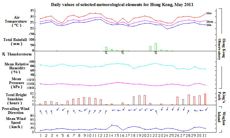
Due to the frequent replenishment of continental airstream over the south China coastal areas, May 2011 was sunnier and drier than usual. The monthly total duration of bright sunshine was 150.5 hours, 11.9 hours above normal. The mean relative humidity of the month was 81 percent, 3 percent below the normal figure of 84 percent. There were two episodes of heavy rain which necessitated the issuance of two red rainstorm warnings on 22 May with the New Territories being hit hardest. Despite the rainstorms, the monthly total rainfall recorded at the Hong Kong Observatory was only 186.7 millimetres, a deficit of about 43 percent comparing with normal. The accumulated rainfall since 1 January was 272.3 millimetres, only about 41 percent of the normal figure of 666.6 millimetres for the same period.
Affected by a warm and humid maritime airstream, the weather in Hong Kong was mainly cloudy with a few showers and coastal fog for the first three days of the month. A cold front developed over inland Guangdong and crossed the coast on the early morning of 4 May. Locally, it became cooler with a few rain patches after the passage of the cold front. Under the influence of a broad cloud band, it was mainly cloudy with mist on 5 and 6 May.
With the setting in of moderate southerly winds, the cloud thinned out and local weather turned mainly fine from 7 to 9 May. The abundant sunshine brought very hot weather condition to the territory for the next three days. The temperature at the Hong Kong Observatory rose to a maximum of 33.0 degrees on the afternoon of 11 May, the highest of the month.
With the passage of an active trough of low pressure over the south China coast, local weather deteriorated with occasional heavy rain and squally thunderstorms on 13 and 14 May. The rainy weather persisted for the next three days with the trough of low pressure lingering along the coast. As the trough of low pressure migrated southwards to the northern part of the South China Sea, a ridge of high pressure established over southern China and the local weather became mainly fine and dry from 18 to 20 May. The relative humidity over parts of the territory once fell below 40 percent on 18 May.
With the return of the trough of low pressure, showers and thunderstorms developed over Hong Kong in the afternoon and evening on 21 May. Rain became heavy with squally thunderstorms on the morning of 22 May as the trough became very active along the coast. Meanwhile, another trough of low pressure over inland Guangdong edged southwards to cross the coast that evening, bringing another episode of heavy rain and squally thunderstorms to the territory. Totally, more than 100 millimetres of rainfall were recorded over most of Hong Kong with more than 200 millimetres over parts of the New Territories on 22 May. There were still a few squally thunderstorms on the morning of 23 May.
The trough of low pressure moved southwards and Hong Kong came under a northerly airstream. Local weather became cooler with some light rain patches on 24 and 25 May. The temperature at the Hong Kong Observatory fell to 19.8 degrees on 24 May, the lowest of the month. Further replenishment of the continental air mass brought sunny and dry weather with haze to Hong Kong from 26 to 28 May. A weak ridge of high pressure maintained generally fine weather in the territory for the last three days of the month.
|
