|
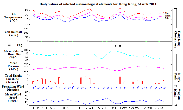
Despite some foggy episodes interspersed during the middle of the month, March 2011 was drier than usual. The monthly mean relative humidity was 71 percent, 11 percent below the normal figure of 82 percent and the lowest for March on record. There was only 20.5 millimetres of rainfall recorded in the month, about 29 percent of the normal.
With frequent replenishment of the northeast monsoon, the month was also cooler than usual. The monthly mean temperature was 18.0 degrees, 0.9 degrees below the normal figure of 18.9 degrees.
The weather started off cloudy and relatively warm on the first day of the month. A cold front which formed over inland Guangdong that morning, crossed the coastal areas before midnight. The northeast monsoon behind the cold front brought cooler weather and a few rain patches to the territory for the next two days. While remaining cool, local weather turned mainly fine and dry with some haze on 4 and 5 March. A moist easterly airstream brought mild and cloudy weather with coastal mist to Hong Kong the next day.
With the passage of another cold front on the morning of 7 March, local weather was misty with a few light rain patches on that day. Affected by the northeast monsoon behind the cold front, the weather was rather cool with some rain patches for the ensuing three days. The temperature at the Hong Kong Observatory fell to a minimum of 12.5 degrees on 9 March, the lowest of the month. With the moderation of the northeast monsoon, there were some sunny periods on 11 and 12 March.
Under the influence of a warm maritime airstream, local weather became humid and foggy from 13 to 15 March. The visibility in the harbour once fell below 500 metres in the morning on 15 March. Meanwhile, a cold front formed over inland Guangdong and crossed the south China coastal areas that afternoon, bringing appreciably cooler weather to the territory in the evening. Affected by the associated northeast monsoon, it remained cool and dry on 16 March.
Due to a fresh to strong easterly airstream blowing along the southeastern coast of China together with a broad rainband covering southern China, Hong Kong experienced cool and windy condition with some rain on 17 and 18 March. The rainy weather persisted on 19 March. Under the influence of a maritime airstream, the weather was foggy and began to warm up on 20 and 21 March. With abundance of sunshine, the temperature at the Hong Kong Observatory rose to a maximum of 27.4 degrees in the afternoon on 21 March, the highest of the month.
A cold front developed over northern part of Guangdong and crossed the coast in the morning on 22 March. Affected by the northeast monsoon behind the cold front, local temperatures in that afternoon were generally 8 to 10 degrees lower than those of the day before. It was mainly fine and dry from 23 to 26 March. As a band of rain-bearing cloud developed over the south China coastal areas, local weather became cool with a few rain patches on 27 March. The rain eased off giving way to mainly fine and dry condition on 28 and 29 March. Local weather turned cloudy again with some light rain on 30 March under the influence of a broad cloud band affecting the northern part of the South China Sea and the coastal areas of Guangdong. Affected by a ridge of high pressure over the coast of southeastern China, it was mainly fine and very dry on the last day of the month. The relative humidity recorded at the Hong Kong Observatory fell to a minimum of 25 percent that afternoon, the lowest for March since 1986.
|
