|
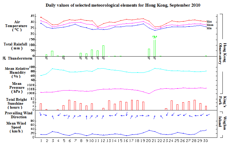
September is the wettest month of this year so far with monthly rainfall of 583.1 millimetres, more than double of the normal figure of 287.5 millimetres. The ample rainfall of September more than compensated the deficit of the first eight months of the year, bringing the accumulated amount since January to 2288.4 millimetres, about 6 percent above the normal figure of 2161.2 millimetres for the same period. Of the total rainfall in September, more than half was attributed to the two tropical cyclones, namely Lionrock and Fanapi, which necessitated the issuance of tropical cyclone warning signals. Both Lionrock and Fanapi made landfall over the coast of southeastern China and then adopted a generally westerly track across inland Guangdong, bringing significant amount of rainfall to Hong Kong during their passages.
Besides the heavy rain episodes, September 2010 was also noted for the intense record-breaking lightning activities. Due to the unstable weather condition, a total of 13102 strokes of cloud-to-ground lightning were registered during the hour immediately after midnight on 9 September, the highest since record began in 2005.
Affected by the subsiding air associated with Severe Tropical Storm Lionrock over the Taiwan Strait, the weather in Hong Kong was fine and very hot for the first day of the month. The temperature at the Hong Kong Observatory rose to a maximum of 34.1 degrees, the highest of the month. On 2 September, Lionrock weakened into a tropical storm and made landfall over the coast of southern Fujian. Locally, it became mainly cloudy with a few showers. Despite Lionrock weakening further while moving westward over inland Guangdong, its associated rainbands brought occasionally heavy rain and squally thunderstorms to the territory on 3 September. The weather remained showery in the next two days, becoming mainly fine and hot on 6 and 7 September.
Under unstable weather condition, severe thundery activities developed and affected the territory on 8 and 9 September. During the hour just after midnight on 9 September, 13102 strokes of cloud-to-ground lightning were registered in Hong Kong, the highest in an hour since record began in 2005. Besides, over 50 millimetres of rainfall was recorded generally over the territory on that day. Affected by a trough of low pressure, there were some episodes of occasional heavy rain from 10 to 12 September. A total of 206.5 millimetres of rainfall were recorded at the Hong Kong Observatory Headquarters during these three days.
With the establishment of a ridge of high pressure, local weather turned fine apart from a few isolated showers from 13 to 15 September. Meanwhile, Fanapi formed over the western North Pacific to the east of the Luzon Strait on 15 September. On its way towards Taiwan, it continued to intensify and attained the intensity of a severe typhoon on 18 September. Affected by the subsiding air ahead of Fanapi, local weather was generally fine and hot from 16 to 19 September. After making landfall over the coastal areas of southern Fujian on 20 September, Fanapi moved westward across inland Guangdong and weakened gradually. Affected by the rainbands of Fanapi, there were heavy rain and squally thunderstorms on 20 and 21 September. A total of 245.8 millimetres of rainfall were recorded at the Hong Kong Observatory Headquarters during these two days.
The remnant of Fanapi continued to affect the south China coastal areas and brought showery weather to Hong Kong on 22 and 23 September. Meanwhile, a cold front formed over southern China and moved southwards gradually, giving rise to a significant temperature drop in the region. The cold front weakened on its way towards the coastal areas of Guangdong and the northeast monsoon behind the cold front brought generally fine condition to the territory from 24 to 29 September. A fresh easterly airstream brought a few rain patches to Hong Kong on the last day of the month.
|
