|
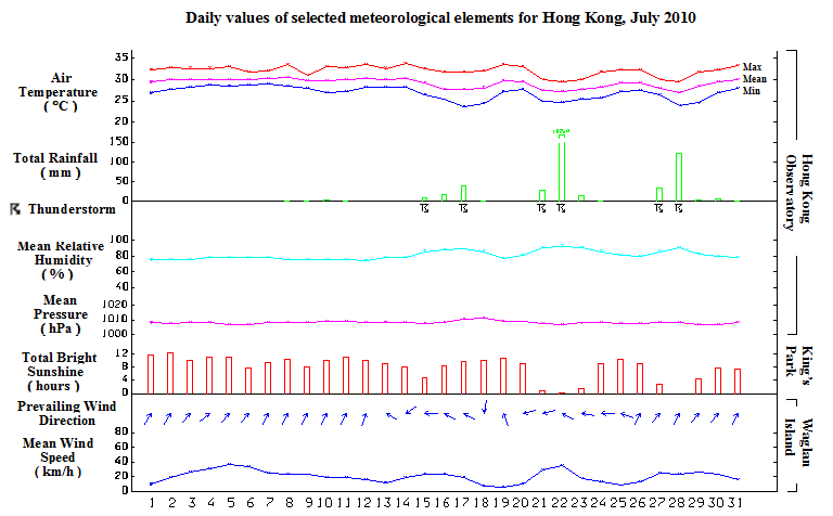
July 2010 was hotter than usual. With eight very hot days (daily maximum temperature of 33.0 degrees or above) in the month, the mean temperature was 29.2 degrees, about 0.5 degrees above normal. Despite a hot month, the two heavy rain episodes which necessitated the issuance of the Black Rainstorm Warning on 22 and 28 July respectively made the month wetter than usual. The total monthly rainfall was 469.4 millimetres, about 25 percent above the normal figure of 374.4 millimetres. The accumulated rainfall since 1 January was 1355.0 millimetres, about 5 percent below the normal figure of 1429.1 millimetres for the same period.
Under the influence of the subtropical ridge, Hong Kong experienced a fine spell with sunny and hot weather apart from a few isolated showers for the first two weeks of the month. On 12 July, the tropical depression to the east of the Philippines intensified into a tropical storm and was named Conson. Conson further intensified into a severe tropical storm that night and tracked westwards across Luzon, entering the South China Sea on 14 July. Due to the subsidence of the air mass ahead of Conson, the temperature recorded at the Hong Kong Observatory rose to a maximum of 33.9 degrees on that day, the highest of the month.
Conson crossed the South China Sea on 15 July. It intensified into a typhoon before moving across the southwestern part of Hainan Island the next day and made landfall over northern Vietnam on 17 July. Under the influence of Conson, local winds freshened with strong winds on high ground. The weather was mainly cloudy with squally showers and thunderstorms from 15 to 17 July.
Affected by a ridge of high pressure, the weather turned generally fine and hot from 18 to 20 July. In the mean time, a tropical depression developed over the South China Sea to the west of Luzon on 19 July. It intensified into a tropical storm and was named Chanthu the next day. Local winds started to pick up and there were squally showers and thunderstorms on 21 July when Chanthu edged closer. Chanthu intensified into a typhoon on 22 July. As Chanthu passed to the southwest of Hong Kong towards the western coast of Guangdong later that day, local winds began to moderate. However, the outer rainbands associated with Chanthu brought unstable weather with heavy rain and thunderstorms to the territory. Over 150 millimetres of rainfall were recorded at Tsim Sha Tsui, Tai Po, Shatin and North Point and a waterspout was seen near Siu Sai Wan. The weather remained cloudy with showers and squally thunderstorms on 23 July.
Under the influence of a ridge of high pressure, the weather improved and there were some sunny periods for the next three days. A trough of low pressure caused occasionally scattered heavy showers and squally thunderstorms to affect the territory on 27 and 28 July. A few funnel clouds and waterspouts were observed near Deep Bay in the morning on 27 July. A heavy rain episode in the afternoon on 28 July brought more than 100 millimetres of rainfall to the urban areas. The rainfall even exceeded 150 millimetres over Lantau, Sai Kung and the eastern part of the New Territories. With the weakening of the trough of low pressure, there were some sunny intervals apart from thundery showers on 29 July. Affected by a weak ridge of high pressure, the weather turned mainly fine and hot for the last two days of the month.
|
