Skip Content

The Weather of December 2009

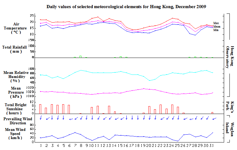
     December 2009 was cooler and wetter than usual.  The monthly mean temperature of 17.3 degrees was 0.5 degrees below normal.  The total rainfall of 50.2 millimetres in the month was about 46 percent above the normal figure of 34.5 millimetres.  The annual rainfall for 2009 was 2182.3 millimetres, about 8 percent below the normal figure of 2382.7 millimetres.

     A dry northeast monsoon brought generally fine weather to Hong Kong for the first six days of the month.  Affected by a fresh to strong easterly airstream over the coastal areas of Guangdong, it became windy and cloudy with rain on 7 and 8 December.  The weather remained generally cloudy with a few rain patches for the next two days.  A ridge of high pressure established over southeastern China brought sunny periods to the territory from 10 to 14 December.  

     As a cold front developed over southern China on 15 December and crossed the coastal areas of Guangdong in the evening, local weather turned cloudy with a few rain patches.  The winter monsoon behind the cold front brought cold weather to Hong Kong for the following six days. 

     With the weakening of the winter monsoon, temperatures started to rise on 22 December. It was mainly fine and mild for the following three days.  However, the light wind condition brought low visibility to parts of the territory on 24 and 25 December.  Under the influence of an easterly airstream over the south China coastal areas, the weather turned cloudy with mist on 26 December.

     A strong cold front formed over southern China on 27 December and moved southwards quickly.  With the passage of the cold front over the territory that afternoon, local weather turned cold and rainy.  The temperature at the Hong Kong Observatory fell from about 18 degrees to a minimum of 9.4 degrees on the morning of 28 December, the lowest of the month.  The weather remained cloudy with rain and mist for the next two days.  A fresh to strong easterly airstream brought generally cloudy condition with a few rain patches to the territory for the last day of the month. 

     One tropical cyclone occurred over the western North Pacific and the South China Sea in the month. 

    Details of issuance and cancellation of various warnings/signals in the month are summarized in Tables 1.1 to 1.3.  Monthly meteorological figures and departures from normal for December are tabulated in Table 2.

Warnings and Signals issued in December 2009


Table 1.1   Strong Monsoon Signal

Beginning Time Ending Time
Day/Month HKT Day/Month HKT
7 / 12 0530 7 / 12 0730
8 / 12 0015 8 / 12 0735
27 / 12 1500 27 / 12 2145
31 / 12 0745 31 / 12 1130


Table 1.2   Fire Danger Warnings

Colour Beginning Time Ending Time
Day/Month HKT Day/Month HKT
Red 3 / 12 0600 3 / 12 1800
Red 5 / 12 0600 5 / 12 1800
Yellow 5 / 12 1800 6 / 12 2320
Yellow 13 / 12 0600 13 / 12 2300
Red 19 / 12 0600 22 / 12 0600
Yellow 25 / 12 0600 25 / 12 1500
Yellow 26 / 12 0605 26 / 12 1800


Table 1.3   Cold Weather Warning

Beginning Time Ending Time
Day/Month HKT Day/Month HKT
15 / 12 1620 21 / 12 1140
27 / 12 1620 29 / 12 0600


Table 2   Figures and Departures from Normal - December 2009

Meteorological Element Figure of the Month Departure from Normal*
Mean Daily Maximum Air Temperature 19.3 degrees C 1.0 degree below normal
Mean Air Temperature 17.3 degrees C 0.5 degree below normal
Mean Daily Minimum Air Temperature 15.6 degrees C 0.1 degree below normal
Mean Dew Point Temperature 13.3 degrees C 1.7 degrees above normal
Mean Relative Humidity 78 % 9 % above normal
Mean Cloud Amount 65 % 14 % above normal
Total Rainfall 50.2 mm 15.7 mm above normal
Number of hours of Reduced VisibilityΔ 266 hours 15.4 hours above normal§
Total Bright Sunshine Duration 124.5 hours 48.8 hours below normal
Mean Daily Global Solar Radiation 9.15 Megajoule / square metre 1.98 Megajoule below normal
Total Evaporation 60.1 mm 34.4 mm below normal


  Remarks : All measurements were made at the Hong Kong Observatory except sunshine, solar radiation and evaporation which were recorded at King's Park Meteorological Station and visibility which was observed at the Hong Kong International Airport.

  Δ

The visibility readings at the Hong Kong International Airport are based on hourly observations by professional meteorological observers in 2004 and before, and average readings over the 10-minute period before the clock hour of the visibility meter near the middle of the south runway from 2005 onwards. The change of the data source in 2005 is an improvement of the visibility assessment using instrumented observations following the international trend.
Before 10 October 2007, the number of hours of reduced visibility at the Hong Kong International Airport in 2005 and thereafter displayed in this web page was based on hourly visibility observations by professional meteorological observers. Since 10 October 2007, the data have been revised using the average visibility readings over the 10-minute period before the clock hour, as recorded by the visibility meter near the middle of the south runway.


  *   Departure from 1971 - 2000 climatological normal, except for number of hours of reduced visibility

  §   Departure from mean value between 1997 and 2008