The Weather of June 2006
|
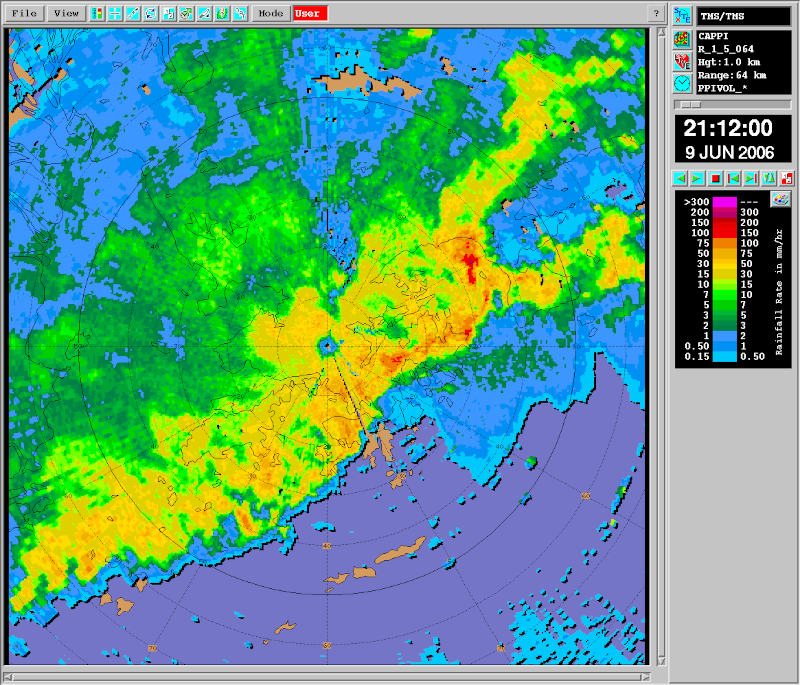
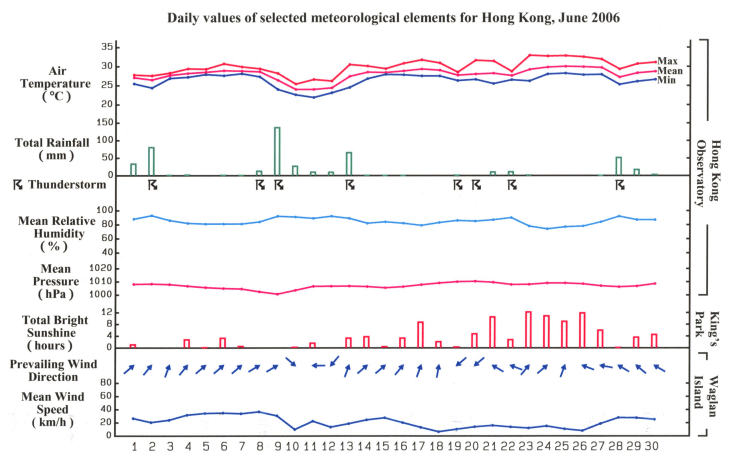
June 2006 was wetter and cloudier than usual. The total rainfall of 469.2 millimetres in the month was 93.2 millimetres above the normal figure. The accumulated rainfall since 1 January amounted to 1202.3 millimetres, 21 percent more than the normal of 992.5 millimetres for the same period. Dominated by rainy and cloudy weather, the total bright sunshine duration in the month was only 107.8 hours, the tenth lowest for June. Affected by an active trough of low pressure, the weather was unsettled with heavy showers and squally thunderstorms on the first three days of the month. The heavy downpour on 2 June brought over 150 millimetres of rainfall to Tsuen Wan, Sha Tin, Sai Kung and the northern part of Lantau Island. The southwest monsoon set in and showery weather prevailed from 4 to 8 June. Heavy rain and squally thunderstorms returned on 9 June as a trough of low pressure over southern China moved towards the coast. More than 100 millimetres of rainfall was recorded over most parts of Hong Kong and there were over 50 reports of flooding. On that night, a squall line developed over the Pearl River Estuary and swept across Hong Kong, bringing heavy rain and severe squalls. Peak gusts of 77 and 101 kilometres per hour were recorded at Central and Shek Kwu Chau respectively. About 20 trees were blown down at Ap Lei Chau. The weather remained showery with a few thunderstorms in the next four days. Local weather improved on 14 June when the trough of low pressure moved away from the south China coast. In the following eight days, the weather was characterized by periods of sunshine and occasional showers. Under the influence of a ridge of high pressure over southeastern China, it was fine and hot on 23 June. Temperature rose to 32.9 degrees, the highest in this month. Apart from a few isolated showers, sunny and hot weather persisted in the ensuing four days. On 27 June, a tropical depression developed over the south China sea and intensified into a tropical storm. Named Jelawat, it moved northwest the next day and skirted the northeastern part of Hainan in the evening. Jelawat weakened into an area of low pressure over the western part of Guangdong on 29 June. The outer rain band of Jelawat brought scattered squally showers and thunderstorms to Hong Kong on 28 and 29 June. The weather turned mainly fine on the last day of the month. Two tropical cyclones occurred in the western North Pacific and the South China Sea in the month. |
| The radar image captured by the Doppler weather radar at Tai Mo Shan at 9:12 p.m. on 9 June 2006. The squall line has just passed Ap Lei Chau and rain started falling there. |
 |
|
Details of issuance and cancellation of various warnings/signals in the month are summarized in Tables 1.1 to 1.6. Monthly meteorological figures and departures from normal for June are tabulated in Table 2. |
Warnings and Signals issued in June 2006
| Name of Tropical Cyclone |
Signal Number |
Beginning Time | Ending Time | ||
|---|---|---|---|---|---|
| Day/Month | HKT | Day/Month | HKT | ||
| JELAWAT | 1 | 27 / 6 | 0940 | 28 / 6 | 1840 |
| Colour | Beginning Time | Ending Time | ||
|---|---|---|---|---|
| Day/Month | HKT | Day/Month | HKT | |
| Amber | 2 / 6 | 1035 | 2 / 6 | 1055 |
| Red | 2 / 6 | 1055 | 2 / 6 | 1445 |
| Amber | 2 / 6 | 1445 | 2 / 6 | 1530 |
| Amber | 9 / 6 | 0200 | 9 / 6 | 0300 |
| Amber | 9 / 6 | 1025 | 9 / 6 | 1055 |
| Red | 9 / 6 | 1055 | 9 / 6 | 1115 |
| Black | 9 / 6 | 1115 | 9 / 6 | 1330 |
| Red | 9 / 6 | 1330 | 9 / 6 | 1420 |
| Amber | 9 / 6 | 1420 | 9 / 6 | 1520 |
| Amber | 9 / 6 | 2040 | 9 / 6 | 2230 |
| Amber | 13 / 6 | 0335 | 13 / 6 | 0415 |
| Red | 13 / 6 | 0415 | 13 / 6 | 0535 |
| Beginning Time | Ending Time | ||
|---|---|---|---|
| Day/Month | HKT | Day/Month | HKT |
| 2 / 6 | 1400 | 2 / 6 | 2215 |
| 9 / 6 | 1430 | 9 / 6 | 1720 |
| Beginning Time | Ending Time | ||
|---|---|---|---|
| Day/Month | HKT | Day/Month | HKT |
| 1 / 6 | 0430 | 1 / 6 | 0900 |
| 1 / 6 | 1120 | 1 / 6 | 1445 |
| 2 / 6 | 0005 | 2 / 6 | 0200 |
| 2 / 6 | 0715 | 2 / 6 | 1515 |
| 2 / 6 | 1615 | 2 / 6 | 1645 |
| 2 / 6 | 1740 | 2 / 6 | 2100 |
| 2 / 6 | 2215 | 3 / 6 | 0600 |
| 3 / 6 | 1050 | 3 / 6 | 1400 |
| 3 / 6 | 1530 | 3 / 6 | 1630 |
| 5 / 6 | 0745 | 5 / 6 | 0845 |
| 6 / 6 | 0910 | 6 / 6 | 1015 |
| 7 / 6 | 0925 | 7 / 6 | 1030 |
| 8 / 6 | 2250 | 9 / 6 | 0600 |
| 9 / 6 | 0725 | 9 / 6 | 1520 |
| 9 / 6 | 1800 | 9 / 6 | 2300 |
| 12 / 6 | 0930 | 12 / 6 | 1030 |
| 12 / 6 | 1335 | 12 / 6 | 1445 |
| 13 / 6 | 0215 | 13 / 6 | 0700 |
| 18 / 6 | 1330 | 18 / 6 | 1430 |
| 18 / 6 | 1450 | 18 / 6 | 1700 |
| 18 / 6 | 2130 | 18 / 6 | 2300 |
| 19 / 6 | 0600 | 19 / 6 | 0900 |
| 19 / 6 | 1115 | 19 / 6 | 1315 |
| 20 / 6 | 1055 | 20 / 6 | 1200 |
| 20 / 6 | 1320 | 20 / 6 | 1630 |
| 20 / 6 | 1810 | 20 / 6 | 1915 |
| 20 / 6 | 2345 | 21 / 6 | 0500 |
| 21 / 6 | 1040 | 21 / 6 | 1245 |
| 21 / 6 | 1320 | 21 / 6 | 1430 |
| 21 / 6 | 1535 | 21 / 6 | 1645 |
| 22 / 6 | 0830 | 22 / 6 | 1500 |
| 26 / 6 | 1313 | 26 / 6 | 1415 |
| 27 / 6 | 0640 | 27 / 6 | 0900 |
| 27 / 6 | 1215 | 27 / 6 | 1415 |
| 28 / 6 | 0905 | 28 / 6 | 1600 |
| 28 / 6 | 1620 | 28 / 6 | 1800 |
| 29 / 6 | 0820 | 29 / 6 | 1000 |
| 29 / 6 | 1120 | 29 / 6 | 1230 |
| 30 / 6 | 0145 | 30 / 6 | 0600 |
| 30 / 6 | 1040 | 30 / 6 | 1145 |
| Beginning Time | Ending Time | ||
|---|---|---|---|
| Day/Month | HKT | Day/Month | HKT |
| 23 / 6 | 1630 | 25 / 6 | 1620 |
| Beginning Time | Ending Time | ||
|---|---|---|---|
| Day/Month | HKT | Day/Month | HKT |
| 9 / 6 | 1040 | 9 / 6 | 1600 |
| Meteorological Element | Figure of the Month | Departure from Normal* |
|---|---|---|
| Mean Daily Maximum Air Temperature | 29.9 degrees C | 0.4 degree below normal |
| Mean Air Temperature | 28.0 degrees C | 0.2 degree above normal |
| Mean Daily Minimum Air Temperature | 26.3 degrees C | 0.4 degree above normal |
| Mean Dew Point Temperature | 25.1 degrees C | 0.7 degree above normal |
| Mean Relative Humidity | 85 % | 3 % above normal |
| Mean Cloud Amount | 77 % | 2 % above normal |
| Total Rainfall | 469.2 mm | 93.2 mm above normal |
| Number of hours of Reduced VisibilityΔ | 9 hours | 16.2 hours below normal§ |
| Total Bright Sunshine Duration | 107.8 hours | 53.3 hours below normal |
| Mean Daily Global Solar Radiation | 13.03 Megajoule / square metre | 3.52 Megajoule below normal |
| Total Evaporation | 97.7 mm | 46.2 mm below normal |
| Remarks : | All measurements were made at the Hong Kong Observatory except sunshine, solar radiation and evaporation which were recorded at King's Park Meteorological Station and visibility which was observed at the Hong Kong International Airport. |
| Δ |
The visibility readings at the Hong Kong International Airport are based on hourly observations by professional meteorological observers in 2004 and before, and average readings over the 10-minute period before the clock hour of the visibility meter near the middle of the south runway from 2005 onwards. The change of the data source in 2005 is an improvement of the visibility assessment using instrumented observations following the international trend. |
|
The calibration factors of the pyranometer at King's Park in 2006 and 2007 have been re-computed based on the results of a regional instrument comparison in Asia in 2007. The readings of total global solar radiation at King's Park in 2006 and 2007 displayed in this web page before 13 June 2008 have been revised on 13 June 2008 using the new calibration factors. |
|
* Departure from 1961-1990 climatological normal, except for number of hours of reduced visibility. |
|
| § Departure from mean value between 1997 and 2005. | |
