The Weather of August 2005
|
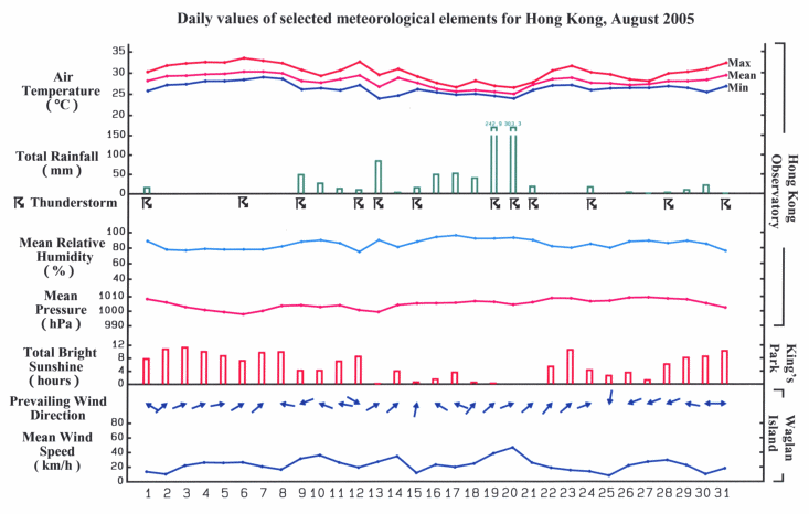
August 2005 was the second wettest August since record began in 1884. The total rainfall of 971.3 millimetres was more than double the normal figure of 391.4 millimetres. Moreover, on 19 and 20 August, the two-day rainfall amounted to 546.2 millimetres and set a new record for August. The accumulated rainfall since 1 January was 2844.2 millimetres, about 67 per cent more than the normal figure of 1707.4 millimetres, and was second only to the rainfall recorded in the same period in 1997. Apart from a few showers, the weather was generally fine and hot on the first eight days of August. Under the influence of the hot subsiding air ahead of Typhoon Matsa to the east of Taiwan, the maximum temperature reached 33.5 degrees on 6 August, the highest in the month. An area of low pressure moved across the northern part of the South China Sea and brought scattered showers to Hong Kong on 9 August and the following two days. The tropical cyclone season started late in Hong Kong this year, in fact, the latest on record. Tropical Storm Sanvu entered the South China Sea in the morning of 12 August and the No. 1 Standby Signal, the first tropical cyclone signal of the year, was issued that morning. Locally, the weather became hot and hazy with thunderstorms in the evening. Sanvu intensified into a Severe Tropical Storm that night and made landfall near Shantou the next day. Affected by the outer rainbands of Sanvu, there were heavy showers and squally thunderstorms in Hong Kong on 13 August. More than 150 millimetres of rainfall was recorded in the central and western parts of the Hong Kong Island. A waterspout with a diameter of about 300 metres was also observed near Tai O that afternoon. With a southerly airstream prevailing over the south China coast, it was cloudy with a few showers and thunderstorms on 14 and 15 August. An active trough of low pressure developed over the northern part of the South China Sea on 16 August and brought scattered showers to Hong Kong. The weather remained showery on the following two days. As the trough of low pressure edged towards the south China coast, there were long periods of rain in Hong Kong on 19 August. Over 200 millimetres of rainfall were generally recorded over the territory that day. In heavy rain and violent squalls, a banyan tree which had thrived for more than a century in Central collapsed, blocking the Lower Albert Road. The weather deteriorated further on 20 August when local southwesterly winds strengthened. The Amber Rainstorm Warning, Strong Monsoon Signal, Landslip Warning, Thunderstorm Warning and the Special Announcement on Flooding in the Northern New Territories were all in force on that day. Widespread and persistent heavy rain brought over 300 millimetres of rainfall to most parts of the territory and resulted in serious flooding and landslides. One man was killed in the landslide in Fu Yung Shan Tusen, Tsuen Wan. About 150 tourists at the Po Lin Monastery on Lantau Island were stranded after landslides blocked the South Lantau Road. They were eventually led to safety by the police. In Tuen Mun, 15 persons trapped by metre-deep flood water were rescued by firemen. The weather remained unstable with scattered heavy showers on 21 August. During the downpour from 19 to 21 August, there were over 30 reports of flooding and more than 100 reports of landslides in various parts of Hong Kong. With the trough of low pressure moving to the north, local weather turned mainly fine on 22 and 23 August. Thundery showers returned on 24 August as the trough drifted back to the south China coast. A funnel cloud was also spotted near the Hong Kong International Airport that morning. Under the influence of an easterly airstream, it was mainly cloudy with isolated showers on 25 August and the following two days. The cloud dispersed and there were sunny periods on 28 August. It stayed mainly fine apart from isolated showers for the rest of the month. Six tropical cyclones occurred in the western North Pacific and South China Sea in the month. |
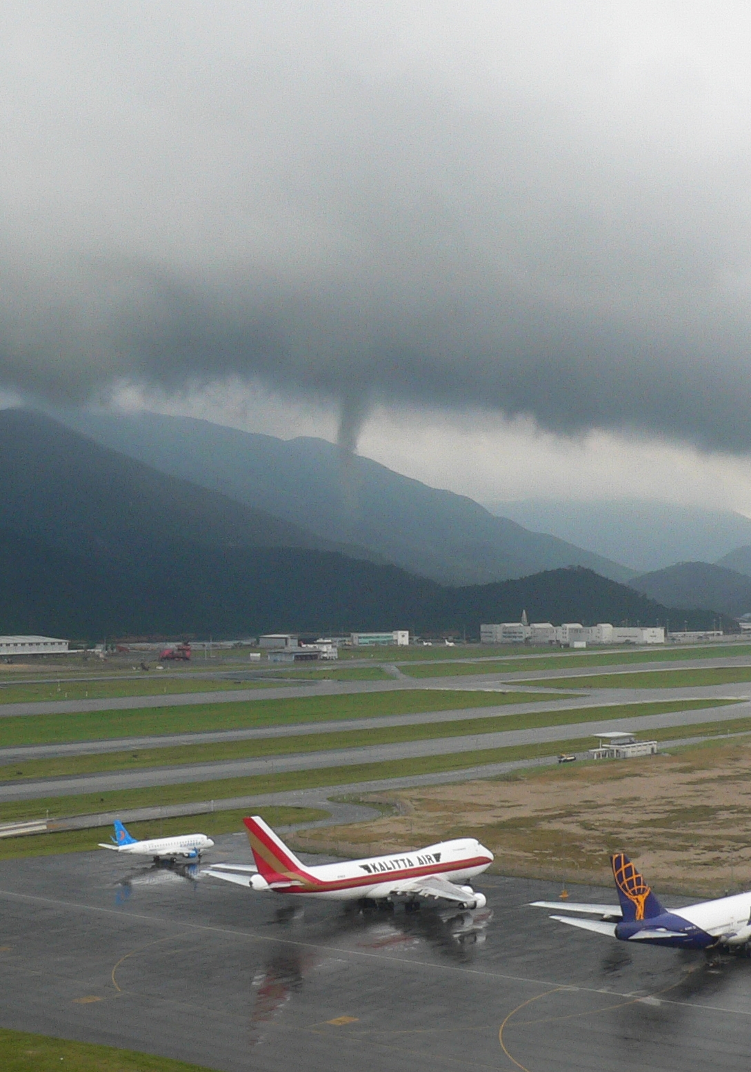
Funnel cloud occurred near the Hong Kong International Airport at around 9:25 a.m. on 24 August 2005.

Details of issuance and cancellation of various warnings/signals in the month are summarized in Tables 1.1 to 1.7. Monthly meteorological figures and departures from normal for August are tabulated in Table 2.
Warnings and Signals issued in August 2005
| Name of Tropical Cyclone |
Signal Number |
Beginning Time | Ending Time | ||
|---|---|---|---|---|---|
| Day/Month | HKT | Day/Month | HKT | ||
| SANVU | 1 | 12 / 8 | 1040 | 13 / 8 | 1845 |
| Beginning Time | Ending Time | ||
|---|---|---|---|
| Day/Month | HKT | Day/Month | HKT |
| 20 / 8 | 0530 | 20 / 8 | 2345 |
| Colour | Beginning Time | Ending Time | ||
|---|---|---|---|---|
| Day/Month | HKT | Day/Month | HKT | |
| Amber | 13 / 8 | 1140 | 13 / 8 | 1315 |
| Amber | 13 / 8 | 2045 | 14 / 8 | 0020 |
| Amber | 19 / 8 | 1925 | 20 / 8 | 0055 |
| Amber | 20 / 8 | 0835 | 20 / 8 | 2110 |
| Beginning Time | Ending Time | ||
|---|---|---|---|
| Day/Month | HKT | Day/Month | HKT |
| 19 / 8 | 2100 | 22 / 8 | 0615 |
| Beginning Time | Ending Time | ||
|---|---|---|---|
| Day/Month | HKT | Day/Month | HKT |
| 1 / 8 | 0105 | 1 / 8 | 0330 |
| 5 / 8 | 0615 | 5 / 8 | 0730 |
| 5 / 8 | 1440 | 5 / 8 | 1645 |
| 6 / 8 | 0435 | 6 / 8 | 0745 |
| 6 / 8 | 1400 | 6 / 8 | 1500 |
| 7 / 8 | 0225 | 7 / 8 | 0430 |
| 7 / 8 | 0945 | 7 / 8 | 1045 |
| 9 / 8 | 0240 | 9 / 8 | 1200 |
| 9 / 8 | 2005 | 10 / 8 | 0015 |
| 10 / 8 | 1440 | 10 / 8 | 1545 |
| 10 / 8 | 1655 | 10 / 8 | 1800 |
| 11 / 8 | 0001 | 11 / 8 | 0200 |
| 12 / 8 | 1800 | 13 / 8 | 0600 |
| 13 / 8 | 1045 | 13 / 8 | 1345 |
| 13 / 8 | 1555 | 14 / 8 | 0300 |
| 15 / 8 | 0855 | 15 / 8 | 1300 |
| 15 / 8 | 1410 | 15 / 8 | 1920 |
| 16 / 8 | 0320 | 16 / 8 | 1100 |
| 17 / 8 | 0015 | 17 / 8 | 0600 |
| 17 / 8 | 0940 | 17 / 8 | 1030 |
| 18 / 8 | 0620 | 18 / 8 | 0730 |
| 19 / 8 | 2000 | 19 / 8 | 2330 |
| 20 / 8 | 0555 | 20 / 8 | 1830 |
| 21 / 8 | 0415 | 21 / 8 | 0730 |
| 21 / 8 | 0900 | 21 / 8 | 2045 |
| 22 / 8 | 0205 | 22 / 8 | 0800 |
| 24 / 8 | 0920 | 24 / 8 | 1430 |
| 25 / 8 | 0515 | 25 / 8 | 0630 |
| 26 / 8 | 1220 | 26 / 8 | 1330 |
| 26 / 8 | 2255 | 26 / 8 | 2400 |
| 27 / 8 | 0515 | 27 / 8 | 0630 |
| 27 / 8 | 0840 | 27 / 8 | 1000 |
| 28 / 8 | 1610 | 28 / 8 | 1710 |
| 29 / 8 | 0100 | 29 / 8 | 0500 |
| 29 / 8 | 1420 | 29 / 8 | 1505 |
| 30 / 8 | 0805 | 30 / 8 | 1000 |
| 31 / 8 | 2305 | 1 / 9 | 0100 |
| Beginning Time | Ending Time | ||
|---|---|---|---|
| Day/Month | HKT | Day/Month | HKT |
| 4 / 8 | 0630 | 4 / 8 | 1745 |
| 6 / 8 | 1425 | 6 / 8 | 1825 |
| Beginning Time | Ending Time | ||
|---|---|---|---|
| Day/Month | HKT | Day/Month | HKT |
| 13 / 8 | 1155 | 13 / 8 | 1300 |
| 20 / 8 | 0915 | 20 / 8 | 2110 |
| Meteorological Element | Figure of the Month | Departure from Normal* |
|---|---|---|
| Mean Daily Maximum Air Temperature | 30.2 degrees C | 1.1 degrees below normal |
| Mean Air Temperature | 28.0 degrees C | 0.4 degree below normal |
| Mean Daily Minimum Air Temperature | 26.3 degrees C | normal |
| Mean Dew Point Temperature | 25.2 degrees C | 0.4 degree above normal |
| Mean Relative Humidity | 85 % | 4 % above normal |
| Mean Cloud Amount | 74 % | 8 % above normal |
| Total Rainfall | 971.3 mm | 579.9 mm above normal |
| Number of hours of Reduced VisibilityΔ | 42 hours | 18.3 hours below normal§ |
| Total Bright Sunshine Duration | 170.2 hours | 36.8 hours below normal |
| Mean Daily Global Solar Radiation | 14.51 Megajoule / square metre | 3.10 Megajoule below normal |
| Total Evaporation | 134.5 mm | 22.4 mm below normal |
| Remarks : | All measurements were made at the Hong Kong Observatory except sunshine, solar radiation and evaporation which were recorded at King's Park Meteorological Station and visibility which was observed at the Hong Kong International Airport. |
| Δ |
The visibility readings at the Hong Kong International Airport are based on hourly observations by professional meteorological observers in 2004 and before, and average readings over the 10-minute period before the clock hour of the visibility meter near the middle of the south runway from 2005 onwards. The change of the data source in 2005 is an improvement of the visibility assessment using instrumented observations following the international trend. |
* Departure from 1961-1990 climatological normal, except for number of hours of reduced visibility. |
|
| § Departure from mean value between 1997 and 2004. | |
