The Weather of July 2005
|
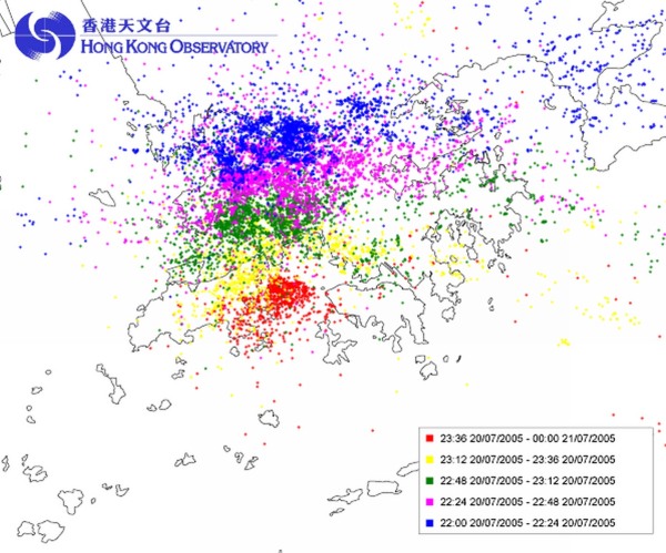
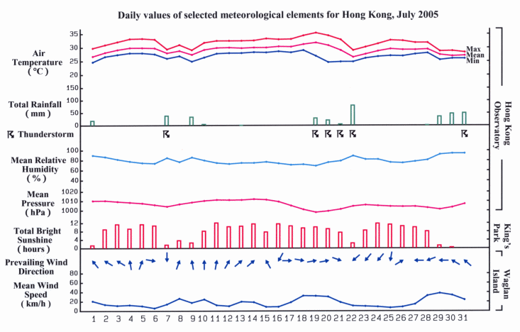
July 2005 was warmer and sunnier than normal. The monthly mean temperature was 29.1 degrees, 0.3 degrees higher than the normal. The total bright sunshine duration was 244.5 hours, 13.4 hours above normal. July 2005 was also wetter than normal. The monthly rainfall of 360.4 millimeters was 36.9 millimeters above the normal figure. The accumulated rainfall since the beginning of the year was 1872.9 millimeters, about 42 percent above the normal for the same period. A trough of low pressure brought showery weather to Hong Kong on the first day of July. Seasonable fine weather prevailed in the next five days as a ridge of high pressure dominated over southern China. With abundant sunshine, the maximum temperature reached 33 degrees for three consecutive days on 4,5 and 6 July. Showers and thunderstorms returned on 7 July as the ridge of high pressure gave way to a broad trough of low pressure over the northern part of the South China Sea. The weather remained unstable with thundery heavy showers in the next two days. The weather turned fine again on 10 July when a ridge of high pressure established itself over the south China coast. Sunny and hot weather persisted in the ensuing six days. Under the influence of Typhoon Haitang over the western North Pacific, it became very hot locally from 17 to 20 July. The intensely heated air in inland Guangdong moved over Hong Kong as it was drawn into the circulation of Typhoon Haitang, bringing the temperature to a maximum of 35.4 degrees on 19 July, the second highest for July on record. Over Guangdong, the intense insolation on 20 July also spawned active thunderstorms which drifted into Hong Kong that night under the northwesterly winds. In the midst of the frequent lightning and thunders, the Observatory's lightning location network recorded some 10000 lightning strokes in Hong Kong in the two-hour period leading up to midnight. The thunderstorms reportedly caused 29 cases of power failure, mainly in Kowloon and the New Territories. On 21 July, Hong Kong was once again hit by severe squally thunderstorms this time in the afternoon. Winds gusting to over 100 kilometres per hour were recorded at Black Point. There were also reports of hail in Tsing Yi. The showery and thundery weather continued into 22 July. The weather improved with sunny periods on 23 July. Apart from a few isolated showers on 24 July, it was generally fine and hot in the next four days. The weather was mainly fine apart from a few showers in Hong Kong on 28 July. The outer rainband associated with tropical storm Washi formed over the northern part of the South China Sea brought squally heavy showers to Hong Kong on 29 July. Gusts of over 100 kilometres per hour were recorded at Cheung Chau that night. The active southerly airstream associated with Washi brought thundery showers to the territory on the last two days of the month. Five tropical cyclones occurred in the western North Pacific and South China Sea in the month. |
| Lightning strikes over Hong Kong from 10 pm to midnight on 20 July as recorded by the Observatory's Lightning Location Network. |
 |
|
Details of issuance and cancellation of various warnings/signals in the month are summarized in Tables 1.1 to 1.3. Monthly meteorological figures and departures from normal for July are tabulated in Table 2. |
Warnings and Signals issued in July 2005
| Colour | Beginning Time | Ending Time | ||
|---|---|---|---|---|
| Day/Month | HKT | Day/Month | HKT | |
| Amber | 19 / 7 | 0205 | 19 / 7 | 0315 |
| Amber | 20 / 7 | 2300 | 21 / 7 | 0135 |
| Beginning Time | Ending Time | ||
|---|---|---|---|
| Day/Month | HKT | Day/Month | HKT |
| 1 / 7 | 0315 | 1 / 7 | 0515 |
| 1 / 7 | 1530 | 1 / 7 | 1930 |
| 7 / 7 | 0455 | 7 / 7 | 1300 |
| 7 / 7 | 1400 | 8 / 7 | 0200 |
| 9 / 7 | 0845 | 9 / 7 | 1125 |
| 9 / 7 | 1230 | 9 / 7 | 1330 |
| 10 / 7 | 0715 | 10 / 7 | 0900 |
| 13 / 7 | 0400 | 13 / 7 | 0515 |
| 16 / 7 | 1220 | 16 / 7 | 1345 |
| 18 / 7 | 2330 | 19 / 7 | 0430 |
| 20 / 7 | 1955 | 21 / 7 | 0530 |
| 21 / 7 | 0815 | 21 / 7 | 0845 |
| 21 / 7 | 1605 | 21 / 7 | 1850 |
| 22 / 7 | 0335 | 22 / 7 | 1300 |
| 23 / 7 | 1225 | 23 / 7 | 1500 |
| 28 / 7 | 0720 | 28 / 7 | 0915 |
| 29 / 7 | 1400 | 29 / 7 | 1500 |
| 30 / 7 | 0405 | 30 / 7 | 0500 |
| 30 / 7 | 0740 | 30 / 7 | 1200 |
| 30 / 7 | 1730 | 30 / 7 | 1815 |
| 31 / 7 | 0200 | 31 / 7 | 1300 |
| Beginning Time | Ending Time | ||
|---|---|---|---|
| Day/Month | HKT | Day/Month | HKT |
| 4 / 7 | 1405 | 6 / 7 | 1905 |
| 16 / 7 | 1145 | 21 / 7 | 1630 |
| Meteorological Element | Figure of the Month | Departure from Normal* |
|---|---|---|
| Mean Daily Maximum Air Temperature | 31.8 degrees C | 0.3 degree above normal |
| Mean Air Temperature | 29.1 degrees C | 0.3 degree above normal |
| Mean Daily Minimum Air Temperature | 26.9 degrees C | 0.3 degree above normal |
| Mean Dew Point Temperature | 25.1 degrees C | 0.2 degree above normal |
| Mean Relative Humidity | 80 % | normal |
| Mean Cloud Amount | 59 % | 6 % below normal |
| Total Rainfall | 360.4 mm | 36.9 mm above normal |
| Number of hours of Reduced VisibilityΔ | 21 hours | 3.5 hours above normal§ |
| Total Bright Sunshine Duration | 244.5 hours | 13.4 hours above normal |
| Mean Daily Global Solar Radiation | 18.49 Megajoule / square metre | 0.66 Megajoule below normal |
| Total Evaporation | 165.8 mm | 5.8 mm below normal |
| Remarks : | All measurements were made at the Hong Kong Observatory except sunshine, solar radiation and evaporation which were recorded at King's Park Meteorological Station and visibility which was observed at the Hong Kong International Airport. |
| Δ |
The visibility readings at the Hong Kong International Airport are based on hourly observations by professional meteorological observers in 2004 and before, and average readings over the 10-minute period before the clock hour of the visibility meter near the middle of the south runway from 2005 onwards. The change of the data source in 2005 is an improvement of the visibility assessment using instrumented observations following the international trend. |
* Departure from 1961-1990 climatological normal, except for number of hours of reduced visibility. |
|
| § Departure from mean value between 1997 and 2004. | |
