The Weather of May 2005
|
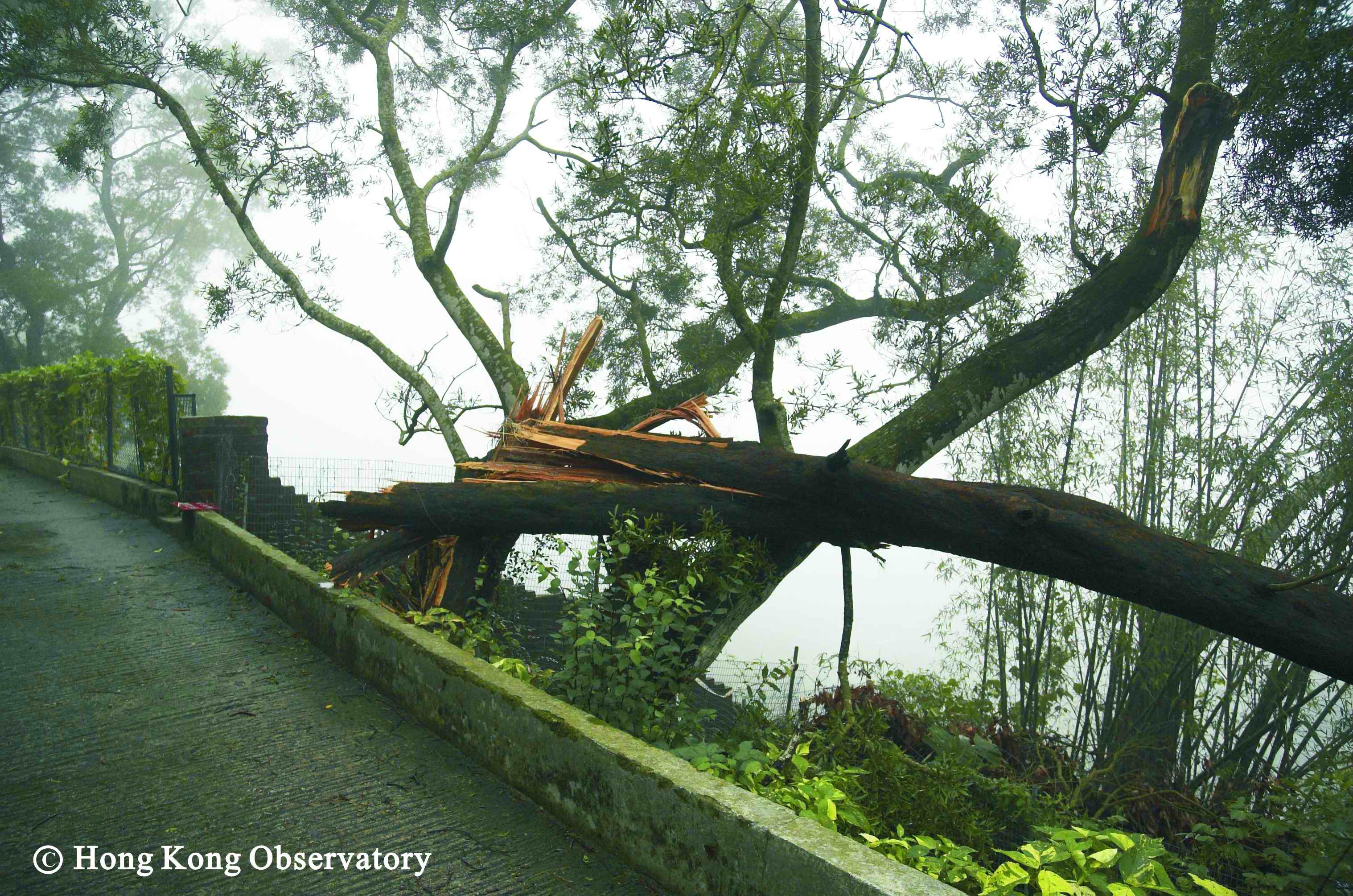
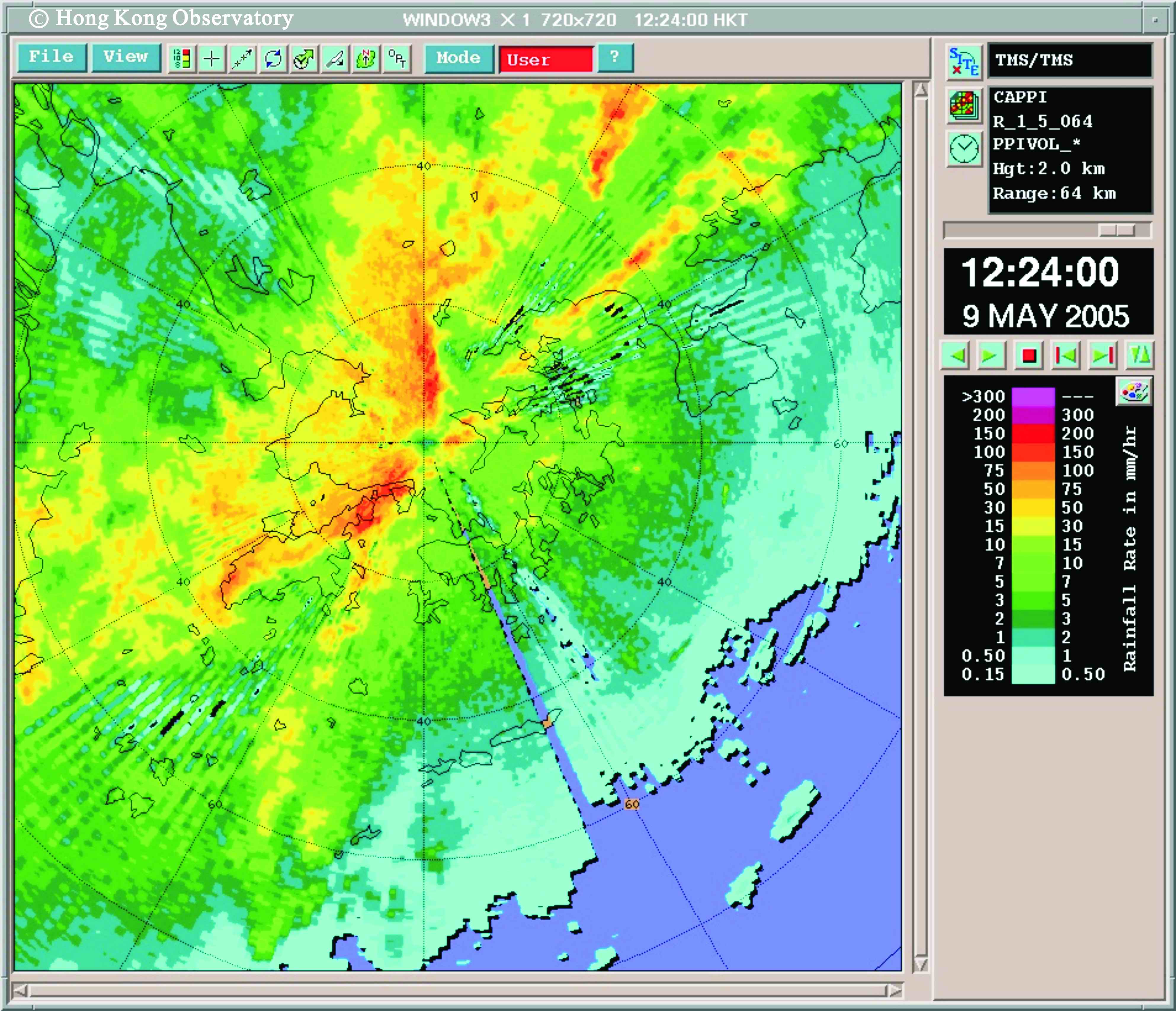
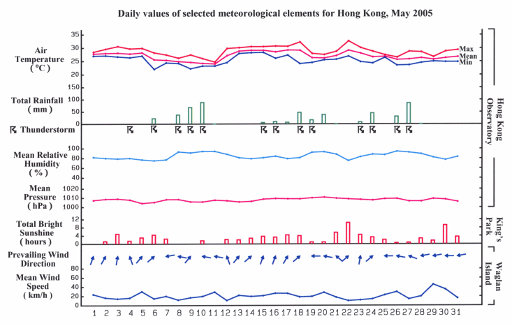
With the monsoon trough recurring near the south China coast, the weather of May 2005 was marked by heavy rain, active thunderstorms and severe squalls. The Amber Rainstorm Warning was issued seven times in the month, a new record for May since the warning system was introduced in 1998. The monthly rainfall of 508.6 millimetres was about 61 percent above the normal. The accumulated rainfall since the beginning of the year was 618.6 millimetres, about the same as the normal figure of 616.5 millimetres. With the excessive rain and cloudy sky, the duration of bright sunshine for the month was a meagre 87.6 hours, the third lowest for May since record began in 1884. The southwest monsoon brought mainly cloudy weather and isolated showers to Hong Kong on the first five days of May 2005. A trough of low pressure moved across the south China coast in the small hours of 6 May, bringing heavy showers and squally thunderstorms to the territory. The weather improved quickly during the day as the trough moved south into the South China Sea. It was mainly cloudy with sunny intervals on 7 May. An extensive band of rain-bearing clouds brought widespread heavy rain and thunderstorms to the territory on 8 May. The Amber Rainstorm Warning and the Special Announcement on Flooding in the Northern New Territories were issued that day for the first time this year. The weather remained unstable on 9 May as a trough of low pressure developed over southern China. Intense thunderstorms associated with the trough moved across the territory around noon that day, bringing heavy rain and severe squalls. At Kwai Chung, severe gusts with speed reaching 135 kilometres per hour were recorded. During the inclement weather, some of the stacked containers in container terminals in Kwai Chung and Tsing Yi collapsed, resulting in one death and two other injured. There were also over 100 reports of fallen trees and scaffoldings. In particular, the fallen trees and scaffoldings respectively in Kowloon Tong and San Po Kong brought the traffic to a standstill in Kowloon. The rainy and thundery condition continued on 10 May. A waterspout was observed in the small hours of the morning off the coast of Chai Wan. Over 100 millimetres of rainfall was recorded in the urban areas, Sha Tin and Lantau Island. The rain gradually eased off on 11 May as the trough of low pressure weakened. With a southerly airstream prevailing over the south China coast, the weather in the next six days was characterized by periods of sunshine and interludes of showers. Thunderstorms and heavy rain returned on 18 May when a trough of low pressure edged towards the coast of Guangdong. The weather remained unsettled with heavy showers and thunderstorms in the next two days. The weather turned fine and hot on 21 and 22 May. With plenty of sunshine, the maximum temperature on 22 May rose to 32.6 degrees, the highest so far this year. Apart from showers and thunderstorms in the morning, it was mainly fine during the day on 23 May. The approach of another trough of low pressure brought thundery showers to Hong Kong on 24 May and the ensuing three days. The rain was particularly heavy in the evening of 27 May, with over 100 millimetres of rainfall recorded in Kwai Chung and the western part of Hong Kong Island. In the evening, the second waterspout of the month was spotted, this time off the coast of Silver Mine Bay. The rain subsided on 28 May as the trough of low pressure moved south to the northern part of the South China Sea. With a ridge of high pressure building over southeastern China, it was mainly fine on the last three days of the month. Only one tropical cyclone occurred in the western North Pacific in the month. |
(Photo taken with the assistance of Kadoorie Farm and Botanic Garden)

Figure 2: Another tree in the Kadoorie Farm and Botanic Garden was snapped off by the ferocious gust.
(Photo taken with the assistance of Kadoorie Farm and Botanic Garden)

Figure 3: An image captured by the Observatory's weather radar at 12:24 p.m. on 9 May 2005, showing a band of heavy rain affecting Hong Kong

Details of issuance and cancellation of various warnings/signals in the month are summarized in Tables 1.1 to 1.4. Monthly meteorological figures and departures from normal for May are tabulated in Table 2.
Warnings and Signals issued in May 2005
| Beginning Time | Ending Time | ||
|---|---|---|---|
| Day/Month | HKT | Day/Month | HKT |
| 29 / 5 | 0900 | 29 / 5 | 1145 |
| Colour | Beginning Time | Ending Time | ||
|---|---|---|---|---|
| Day/Month | HKT | Day/Month | HKT | |
| Amber | 8 / 5 | 1035 | 8 / 5 | 1400 |
| Amber | 9 / 5 | 1210 | 9 / 5 | 1420 |
| Amber | 10 / 5 | 0235 | 10 / 5 | 0500 |
| Amber | 10 / 5 | 1115 | 10 / 5 | 1230 |
| Amber | 18 / 5 | 2250 | 19 / 5 | 0030 |
| Amber | 20 / 5 | 1930 | 20 / 5 | 2200 |
| Amber | 27 / 5 | 1835 | 27 / 5 | 2035 |
| Beginning Time | Ending Time | ||
|---|---|---|---|
| Day/Month | HKT | Day/Month | HKT |
| 4 / 5 | 1325 | 4 / 5 | 1600 |
| 6 / 5 | 0215 | 6 / 5 | 0715 |
| 8 / 5 | 0805 | 8 / 5 | 1400 |
| 9 / 5 | 1125 | 9 / 5 | 1530 |
| 9 / 5 | 1845 | 9 / 5 | 2245 |
| 10 / 5 | 0040 | 10 / 5 | 0600 |
| 10 / 5 | 0720 | 10 / 5 | 1330 |
| 10 / 5 | 1945 | 10 / 5 | 2145 |
| 15 / 5 | 2358 | 16 / 5 | 0430 |
| 17 / 5 | 0955 | 17 / 5 | 1400 |
| 18 / 5 | 1535 | 18 / 5 | 1735 |
| 18 / 5 | 2105 | 19 / 5 | 1500 |
| 19 / 5 | 1645 | 19 / 5 | 1745 |
| 20 / 5 | 1045 | 20 / 5 | 1245 |
| 20 / 5 | 1420 | 20 / 5 | 1620 |
| 20 / 5 | 1900 | 20 / 5 | 2400 |
| 23 / 5 | 0435 | 23 / 5 | 1200 |
| 23 / 5 | 1450 | 23 / 5 | 1650 |
| 24 / 5 | 0130 | 24 / 5 | 1245 |
| 26 / 5 | 0825 | 26 / 5 | 0945 |
| 26 / 5 | 1235 | 26 / 5 | 1430 |
| 26 / 5 | 1930 | 27 / 5 | 0130 |
| 27 / 5 | 1310 | 27 / 5 | 1420 |
| 27 / 5 | 1730 | 28 / 5 | 0030 |
| Beginning Time | Ending Time | ||
|---|---|---|---|
| Day/Month | HKT | Day/Month | HKT |
| 8 / 5 | 1010 | 8 / 5 | 1210 |
| Meteorological Element | Figure of the Month | Departure from Normal* |
|---|---|---|
| Mean Daily Maximum Air Temperature | 28.8 degrees C | 0.1 degree above normal |
| Mean Air Temperature | 27.0 degrees C | 1.1 degrees above normal |
| Mean Daily Minimum Air Temperature | 25.3 degrees C | 1.4 degrees above normal |
| Mean Dew Point Temperature | 24.1 degrees C | 1.5 degrees above normal |
| Mean Relative Humidity | 85 % | 2 % above normal |
| Mean Cloud Amount | 82 % | 8 % above normal |
| Total Rainfall | 508.6 mm | 191.9 mm above normal |
| Number of hours of Reduced VisibilityΔ | 14 hours | 34.8 hours below normal§ |
| Total Bright Sunshine Duration | 87.6 hours | 66.2 hours below normal |
| Mean Daily Global Solar Radiation | 10.96 Megajoule / square metre | 5.16 Megajoule below normal |
| Total Evaporation | 92.4 mm | 45.3 mm below normal |
| Remarks : | All measurements were made at the Hong Kong Observatory except sunshine, solar radiation and evaporation which were recorded at King's Park Meteorological Station and visibility which was observed at the Hong Kong International Airport. |
| Δ |
The visibility readings at the Hong Kong International Airport are based on hourly observations by professional meteorological observers in 2004 and before, and average readings over the 10-minute period before the clock hour of the visibility meter near the middle of the south runway from 2005 onwards. The change of the data source in 2005 is an improvement of the visibility assessment using instrumented observations following the international trend. |
* Departure from 1961-1990 climatological normal, except for number of hours of reduced visibility. |
|
| § Departure from mean value between 1997 and 2004. | |
