The Weather of May 2004
|
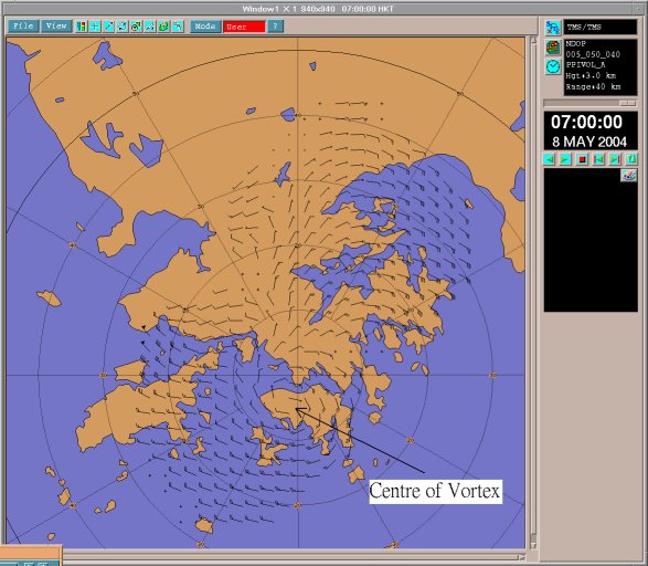
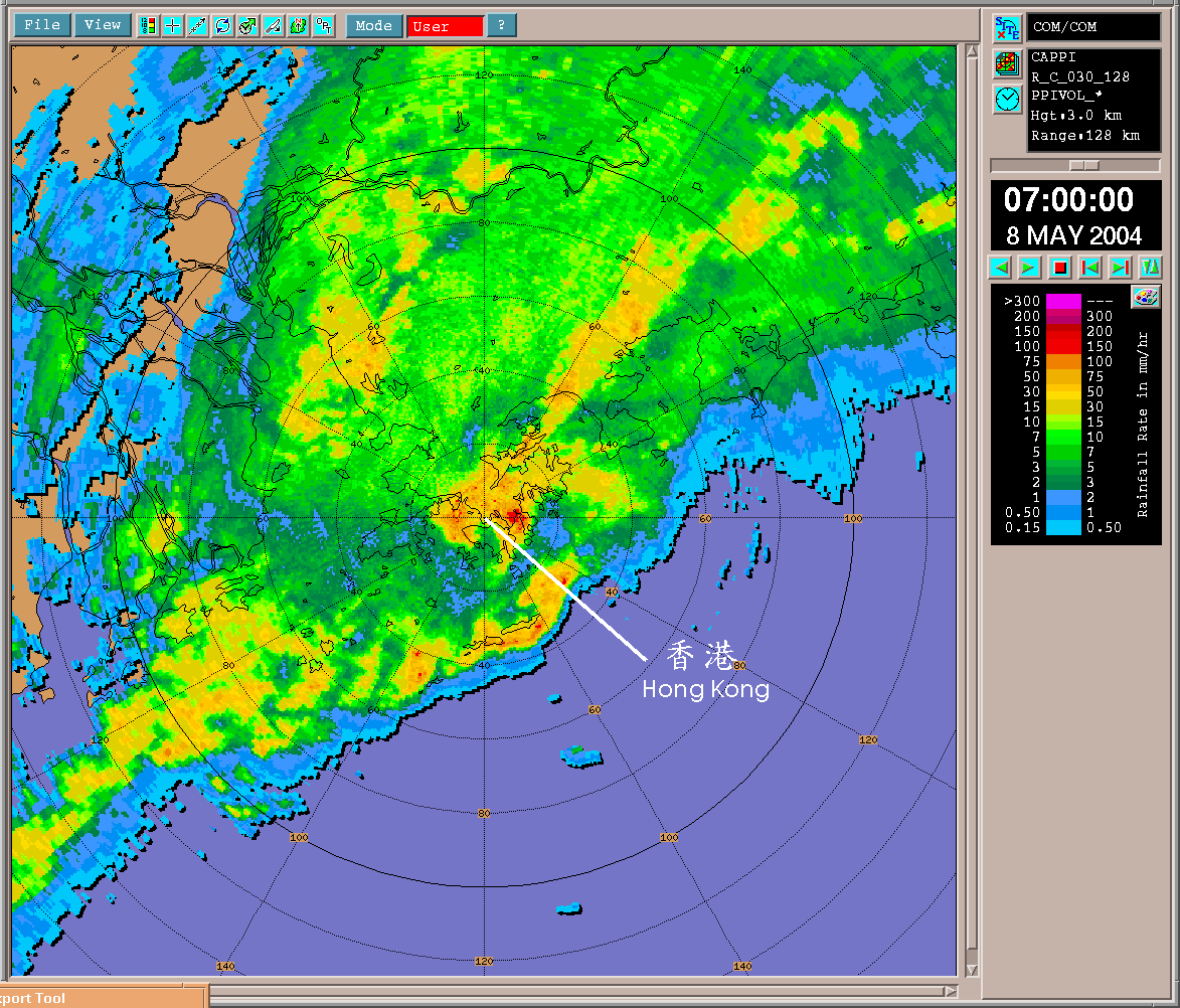
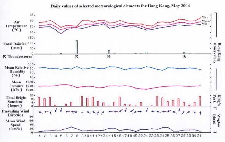
Despite the heavy downpour leading to the issuance of a Black Rainstorm Warning on 8 May, the month was drier than usual. The monthly total rainfall of 194.4 millimetres was 122.3 millimetres below the normal figure. The accumulated rainfall since 1 January was 548.7 millimetres, about 11 per cent below the normal figure of 616.5 millimetres for the same period. Under the influence of a warm maritime airstream, the weather was hot and fine in the first three days of May 2004. A cold front crossed the coast of Guangdong on the morning of 4 May, bringing cloudy weather and some rain patches to Hong Kong. The weather became cooler on 5 May with a minimum temperature of 19.0 degrees, the lowest in the month. Mainly cloudy weather continued in the next two days. A rain band associated with an upper-air disturbance swept through Hong Kong on the morning of 8 May and brought widespread heavy rain and squally thunderstorms to the territory. The Black Rainstorm Warning was issued for the first time this year. The rain was heaviest when an upper air vortex developed and passed over Hong Kong, bringing more than 100 millimetres of rainfall to the urban areas and over 150 millimetres in Lantau Island, Kwai Tsing and Sai Kung in about 2 hours. There were reports of a tornado in Sheung Sze Wan and the sea area off Wang Chau in the eastern part of Hong Kong. A 24-metre long fishing vessel was sunk in the inclement weather with one person missing. There were also 22 reports of floods, mostly in Kowloon. Figures 1 and 2 show an embedded vortex in an extensive rain band at the height of the rainstorm that morning. The weather rapidly turned fine on 9 May as a ridge of high pressure established itself over southern China. Generally fine weather prevailed in the ensuing three days. Showers returned on 13 May as a trough of low pressure edged towards the coast of Guangdong. There were thunderstorms and heavy showers the next day, bringing more than 30 millimetres of rainfall to most parts of Hong Kong. The showers ceased and there were sunny periods on 15 May as the trough dissipated. The weather was fine and hot on 16 May. The weather turned cloudy again on 17 and 18 May. A trough of low pressure developed over the coast of Guangdong on 19 May and brought showers to Hong Kong. The weather remained cloudy with some showers in the next two days, but improved with sunny intervals on 22 May as the trough of low pressure moved south into the South China Sea. A ridge of high pressure built up over southeastern China on 23 May, bringing fine and hot weather to Hong Kong. The weather was mainly fine for the rest of the month, but interrupted by showers and thunderstorms on 28 and 29 May. With prolonged sunshine, the maximum temperature on 31 May soared to 32.4 degrees, the highest so far this year. Three tropical cyclones occurred over the western North Pacific and South China Sea in May. Details of issuance and cancellation of various warnings/signals in the month are summarized in Tables 1.1 to 1.3. Monthly meteorological figures and departures from normal for May are tabulated in Table 2. |
Warnings and Signals issued in May 2004
| Beginning Time | Ending Time | ||
|---|---|---|---|
| Day/Month | HKT | Day/Month | HKT |
| 4 / 5 | 1845 | 4 / 5 | 2230 |
| Colour | Beginning Time | Ending Time | ||
|---|---|---|---|---|
| Day/Month | HKT | Day/Month | HKT | |
| Amber | 8 / 5 | 0410 | 8 / 5 | 0640 |
| Red | 8 / 5 | 0640 | 8 / 5 | 0720 |
| Black | 8 / 5 | 0720 | 8 / 5 | 0800 |
| Red | 8 / 5 | 0800 | 8 / 5 | 1015 |
| Amber | 8 / 5 | 1015 | 8 / 5 | 1100 |
| Amber | 14 / 5 | 0955 | 14 / 5 | 1130 |
| Beginning Time | Ending Time | ||
|---|---|---|---|
| Day/Month | HKT | Day/Month | HKT |
| 4 / 5 | 0630 | 4 / 5 | 1230 |
| 8 / 5 | 0130 | 8 / 5 | 1030 |
| 14 / 5 | 0320 | 14 / 5 | 0520 |
| 14 / 5 | 0620 | 14 / 5 | 1200 |
| 27 / 5 | 1350 | 27 / 5 | 1450 |
| 28 / 5 | 1020 | 29 / 5 | 0020 |
| 29 / 5 | 0525 | 29 / 5 | 0725 |
| 29 / 5 | 1115 | 29 / 5 | 1445 |
| 30 / 5 | 1300 | 30 / 5 | 1600 |
| Meteorological Element | Figure of the Month | Departure from Normal |
|---|---|---|
| Mean Daily Maximum Air Temperature | 28.6 degrees C | 0.1 degree below normal |
| Mean Air Temperature | 26.3 degrees C | 0.4 degree above normal |
| Mean Daily Minimum Air Temperature | 24.5 degrees C | 0.6 degree above normal |
| Mean Dew Point Temperature | 22.9 degrees C | 0.3 degree above normal |
| Mean Relative Humidity | 82 % | 1 % below normal |
| Mean Cloud Amount | 71 % | 3 % below normal |
| Total Rainfall | 194.4 mm | 122.3 mm below normal |
| Total Bright Sunshine Duration | 163.5 hours | 9.7 hours above normal |
| Mean Daily Global Solar Radiation | 15.50 Megajoule / square metre | 0.62 Megajoule below normal |
| Total Evaporation | 122.5 mm | 15.2 mm below normal |
| Remarks : | All measurements were made at the Hong Kong Observatory except sunshine, solar radiation and evaporation which were recorded at King's Park Meteorological Station. |
Figure 1: A vortex at 3 km above mean sea level over Hong Kong Island was depicted by the Doppler radars at Tai Mo Shan and Tate's Cairn.

Figure 2: An image captured by the Observatory's weather radar at 7 a.m. on 8 May 2004, showing a band of heavy rain affecting Hong Kong.

