The Year's Weather – 2019
Wednesday, 8th January 2020
Globally, 2019 is likely to be the second or third warmest year on record according to the World Meteorological Organization's preliminary assessment. Over the Arctic, the daily sea-ice extent minimum in September 2019 was the second lowest in the satellite record and October has seen further record low extents. In 2019, various extreme weather events ravaged different parts of the world, including unrelenting heatwaves in much of western and northern Europe, Middle East, India, Japan, Australia, New Zealand and southern South America, a significant cold spell in central North America, severe drought in many parts of southeast Asia, the southwest Pacific, eastern Australia and Greater Horn of Africa. Extreme rainfall triggered severe flooding in western and northern India, parts of southern China, Iran, northern Queensland of Australia, west coast of New Zealand’s South Island, Jayapura of Indonesia, large part of the central United States and parts of Eastern Canada. High winds, storm surges and torrential rain induced by tropical cyclones brought severe damages and heavy casualties to parts of the United States east coast, eastern Texas, Nova Scotia of Canada, Japan, India, the Philippines, Mozambique, parts of Zimbabwe and the Bahamas. Severe storms brought significant damages to parts of Spain, southern France, Corsica of France, Venice of Italy, Thessaloniki of Greece, eastern Africa, Pakistan and northern and western India. High temperature and drought also contributed to destructive wildfires in western North America, Alaska, Siberia of Russia, Amazon basin, Bolivia, Venezuela, Indonesia and many parts of Australia.
A weak El Niño event was established in early 2019. Sea surface temperatures of the central and eastern equatorial Pacific then cooled and returned to normal in July. The sea surface temperatures of the region exhibited some warming towards the end of the year.
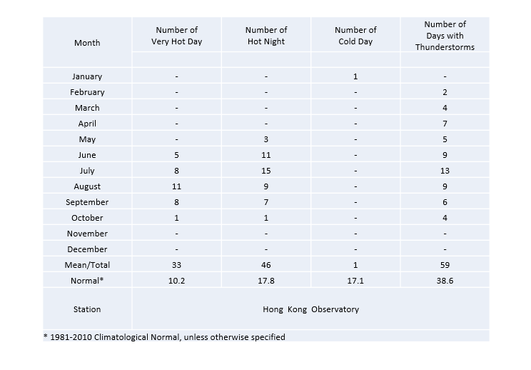
In Hong Kong, with eleven out of the twelve months warmer than usual, 2019 was the warmest year since records began in 1884 with an annual mean temperature of 24.5 degrees, 1.2 degrees above the 1981-2010 normal[1] (or 1.5 degrees above the 1961-1990 normal). The annual mean maximum temperature of 27.1 degrees and annual mean minimum temperature of 22.6 degrees were also the highest on record. In particular, the mean temperatures for winter (December 2018 to February 2019) and autumn (September to November 2019) respectively reached 19.1 degrees and 26.1 degrees, both ranking the highest on record. The highest temperature recorded at the Hong Kong Observatory in the year was 35.1 degrees on 9 August, the fourteenth highest on record. There were 46 Hot Nights[2] and 33 Very Hot Days[3] in Hong Kong in 2019, ranking the highest and one of the fourth highest on record respectively.
The lowest temperature recorded at the Hong Kong Observatory in the year was 11.4 degrees on 1 January, the highest annual absolute minimum temperature on record. There was only one Cold Day[4] in the year, which is 16.1 days less than the 1981-2010 normal and the fewest annual number of Cold Days since 1884.
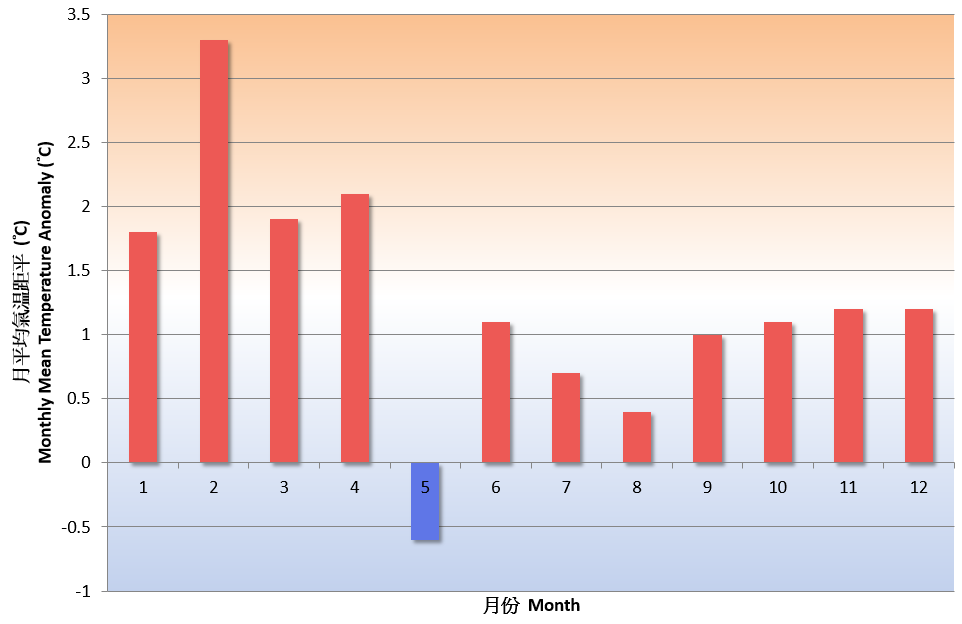
Fig.1 Monthly mean temperature anomalies in Hong Kong in 2019
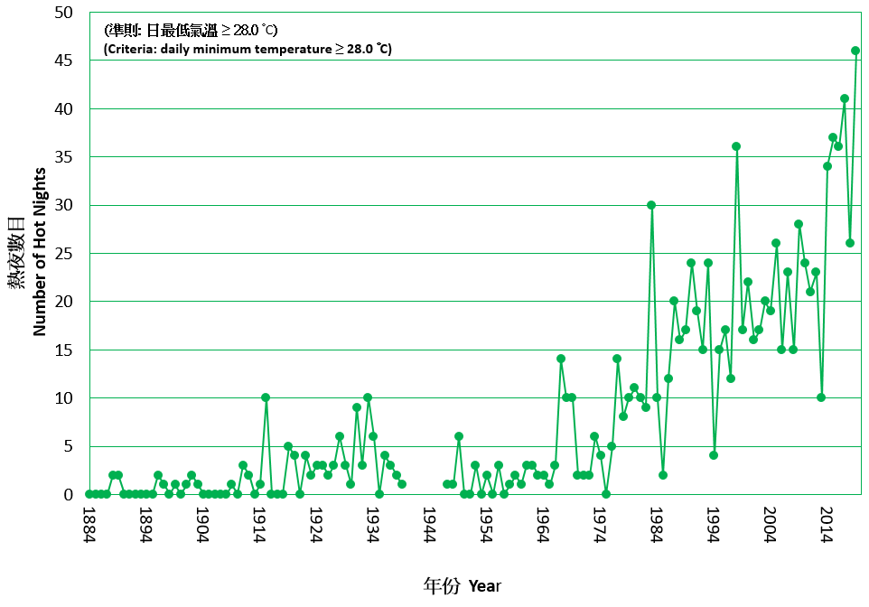
Fig.2 Long-term time series of number of Hot Nights in Hong Kong 1884-2019
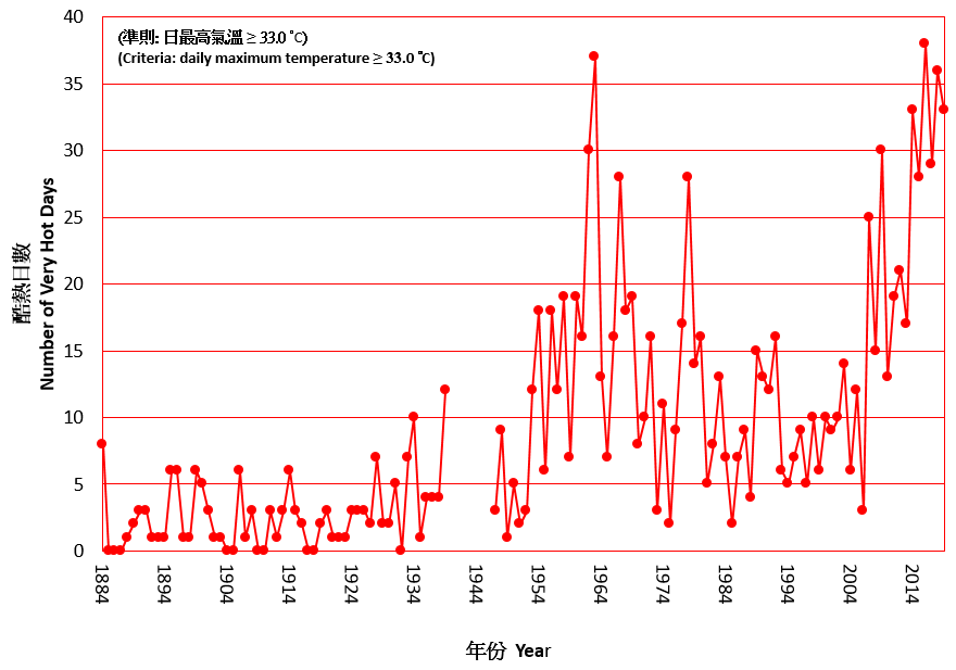
Fig.3 Long-term time series of number of Very Hot Days in Hong Kong 1884-2019
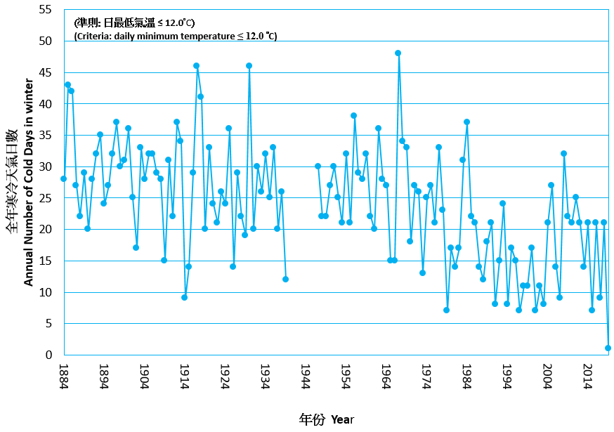
Fig.4 Long-term time series of number of Cold Days in Hong Kong 1884-2019
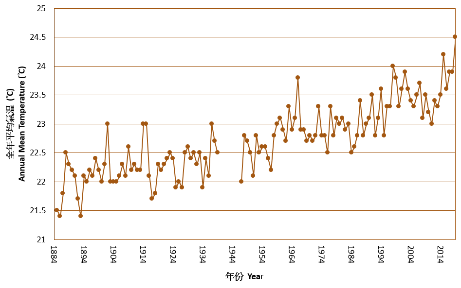
Fig. 5 Long-term time series of annual mean temperature in Hong Kong 1885-2019
The annual total rainfall was 2396.2 millimetres, near the 1981-2010 normal of 2398.5 millimetres (or about 8 percent above the 1961-1990 normal). Three red rainstorm warnings were issued by the Hong Kong Observatory in 2019. There was no black rainstorm warning issued in the year. 2019 was a thundery year in Hong Kong with thunderstorms reported on 59 days, which is 20.4 days above the annual normal of 38.6 days and one of the highest since records began in 1947.
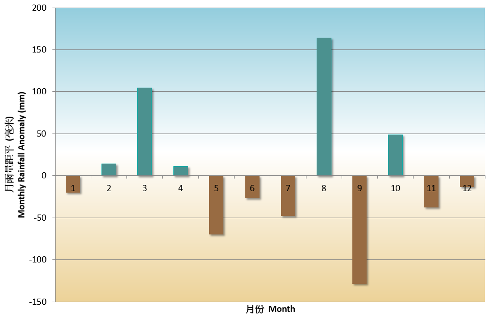
Fig. 6 Monthly rainfall anomalies in Hong Kong in 2019
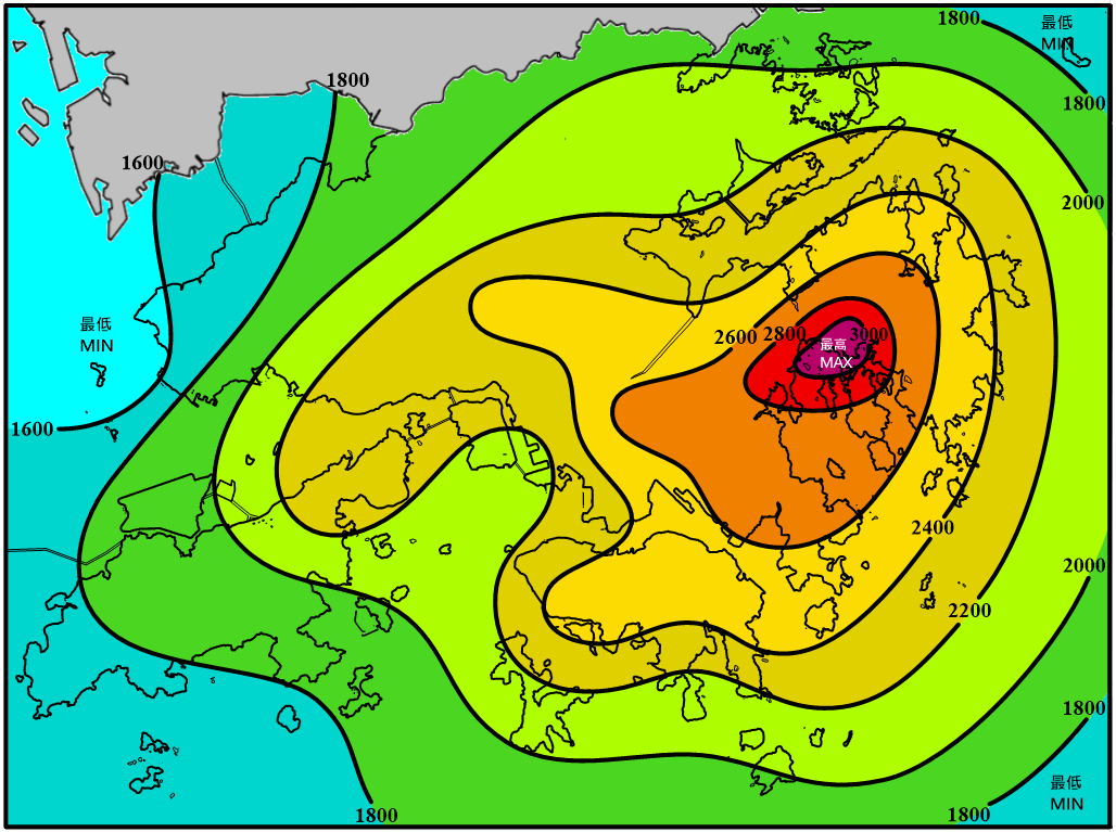
Fig.7 Annual rainfall (millimetres) distribution in Hong Kong in 2019
A total of 28 tropical cyclones occurred over the western North Pacific and the South China Sea in 2019, less than the long-term (1961-2010) average of about 30. There were 16 tropical cyclones reaching typhoon intensity[5] or above during the year, slightly more than the long-term average of about 15, and seven of them reached super typhoon intensity (maximum 10-minute wind speed of 185 km/h or above near the centre). In Hong Kong, five tropical cyclones necessitated the issuance of tropical cyclone warning signals, slightly less than the long-term average of about six in a year. The No. 8 Gale or Storm Signal was issued during the passage of Wipha in July, while the No. 3 Strong Wind Signal was issued during the passage of Kajiki in September.
Detailed description of the weather for individual months is available on the Monthly Weather Summary webpage:
https://www.weather.gov.hk/en/wxinfo/pastwx/mws/mws.htm
Some significant weather events in Hong Kong in 2019 are highlighted below:
Warmest winter and autumn
With unseasonably warm weather persisting from December 2018 to February 2019, Hong Kong experienced the warmest winter on record since 1884. The mean temperature, mean maximum temperature and mean minimum temperature for the winter from December 2018 to February 2019 reached 19.1 degrees, 21.4 degrees and 17.5 degrees respectively. All were the highest on record and more than 2 degrees above their corresponding normals.
Owing to the dominance of upper-air anticyclone over southern China for most of the time in September and October 2019 as well as prolonged dry and sunny weather in November 2019, the autumn mean temperature in Hong Kong reached 26.1 degrees and was 1.1 degrees above the normal of 25.0 degrees, making it one of the warmest autumns on record. Furthermore, the autumn mean maximum temperature of 29.1 degrees was also the highest on record.
Highest number of Hot Nights and fewest number of Cold Days
The annual number of Hot Nights in 2019 reached 46, which is 28.2 days above the normal and the highest on record since 1884. Moreover, seven consecutive Hot Nights were recorded from 8 September to 14 September, the longest on record for September since 1884. With exceptionally warm winter and autumn, there was only one Cold Day in the whole year, the fewest on record.
Severe squally thunderstorms on 20 April
A band of intense thunderstorms packed with frequent lightning, heavy rain and severe squalls swept across Hong Kong in the afternoon of 20 April. The severe squalls associated with the thunderstorms induced gusts exceeding 100 kilometres per hour in some places in Hong Kong. The maximum gust recorded at King’s Park near the city centre was 117 kilometres per hour. Excluding tropical cyclone cases, this is the highest record of gust since the operation of the automatic weather station in King’s Park in 1992. Moreover, about 9090 cloud-to-ground lightning strokes were detected in Hong Kong on that day, the highest on record for April since the launch of the lightning location system in 2005. During the inclement weather in that afternoon, a person died after being struck by lightning while hiking and two persons were tragically drowned when a sampan capsized in rough seas. There were also reports of tree failure and scaffolding collapsing in different parts of the territory.
Notes :
[1] Climatological normals for the reference period of 1961-1990, 1971-2000 and 1981-2010 are available at : https://www.weather.gov.hk/en/cis/normal.htm Climatological normals of 1981-2010 are referenced in the text unless otherwise stated.
[2] 'Hot Night' refers to the condition with the daily minimum temperature equal to or higher than 28.0 degrees.
[3] 'Very Hot Day' refers to the condition with the daily maximum temperature equal to or higher than 33.0 degrees.
[4] 'Cold Day' refers to the condition with the daily minimum temperature equal to or lower than 12.0 degrees.
[5] Information on the classification of Tropical Cyclones is available at: https://www.weather.gov.hk/en/informtc/class.htm
Table 1 Summary of record-breaking high temperature events in 2019
| Record-breaking Events (since records began in 1884) |
Date / Period | New Record |
| 1. Highest Mean Temperature for winter | December 2018 to February 2019 | 19.1℃ |
| 2. Fewest number of Cold Days for winter | December 2018 to February 2019 | 3 days |
| 3. Highest Mean Temperature for 1st to 3rd day of Lunar New Year | 5 February to 7 February 2019 | 21.8℃ |
| 4. Highest Daily Minimum Temperature for March* | 22 March 2019 | 24.8℃ |
| 5. Highest Monthly Mean Minimum Temperature for April** | April 2019 | 22.9℃ |
| 6. Highest Daily Mean Temperature for April*** | 25 April 2019 | 28.5℃ |
| 7. Highest Daily Minimum Temperature for May | 19 May 2019 | 29.2℃ |
| 8. Highest Daily Mean Temperature for Summer Solstice | 21 June 2019 | 30.8℃ |
| 9. Highest Daily Minimum Temperature for Summer Solstice | 21 June 2019 | 29.5℃ |
| 10. Highest Daily Minimum Temperature for June**** | 29 June 2019 | 29.5℃ |
| 11. Highest Mean Temperature for first half of year | January to June 2019 | 23.0℃ |
| 12. Highest Mean Maximum Temperature for first half of year | January to June 2019 | 25.4℃ |
| 13. Highest Mean Minimum Temperature for first half of year | January to June 2019 | 21.3℃ |
| 14. Highest Monthly Mean Minimum Temperature for July | July 2019 | 27.7℃ |
| 15. Highest Daily Maximum Temperature for Mid-Autumn Festival | 13 September 2019 | 33.0℃ |
| 16. Highest Number of Hot Nights for September# | September 2019 | 7 days |
| 17. Highest Number of Consecutive Hot Nights for September | September 2019 | 7 days |
| 18. Highest Daily Mean Temperature for October | 1 October 2019 | 30.3℃ |
| 19. Highest Daily Mean Temperature for National Day | 1 October 2019 | 30.3℃ |
| 20. Highest Daily Minimum Temperature for National Day | 1 October 2019 | 28.4℃ |
| 21. Highest Mean Temperature for autumn## | September to November 2019 | 26.1℃ |
| 22. Highest Mean Maximum Temperature for autumn | September to November 2019 | 29.1℃ |
| 23. Highest Mean Temperature for second half of year | July to December 2019 | 26.0℃ |
| 24. Highest Mean Maximum Temperature for second half of year | July to December 2019 | 28.9℃ |
| 25. Highest Annual Number of Hot Nights | 2019 | 46 days |
| 26. Fewest Annual Number of Cold Days | 2019 | 1 day |
| 27. Highest Annual Mean Temperature | 2019 | 24.5℃ |
| 28. Highest Annual Mean Maximum Temperature | 2019 | 27.1℃ |
| 29. Highest Annual Mean Minimum Temperature | 2019 | 22.6℃ |
| 30. Highest Annual Absolute Minimum Temperature | 2019 | 11.4℃ |
* Joint highest record with 19 March 1999
** Joint highest record with April 1998
*** Joint highest record with 26 April 1994 and 30 April 2012
**** Joint highest record with 21 June 2019
# Joint highest record with September 2008 and September 2009
## Joint highest record with September to November 2015
** Joint highest record with April 1998
*** Joint highest record with 26 April 1994 and 30 April 2012
**** Joint highest record with 21 June 2019
# Joint highest record with September 2008 and September 2009
## Joint highest record with September to November 2015
Table 2a Summary of meteorological observations in Hong Kong, 2019
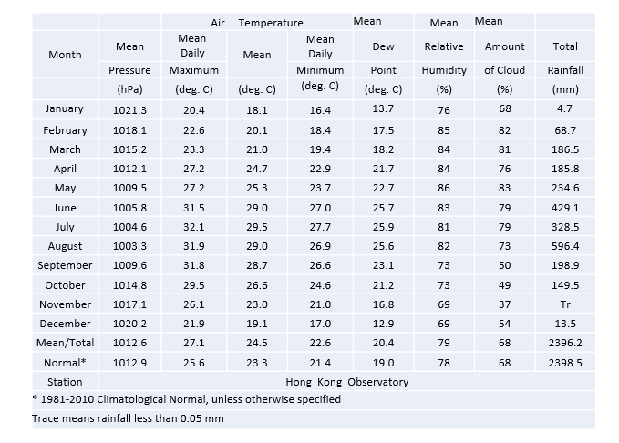
Table 2b Summary of meteorological observations in Hong Kong, 2019
Table 2b Summary of meteorological observations in Hong Kong, 2019
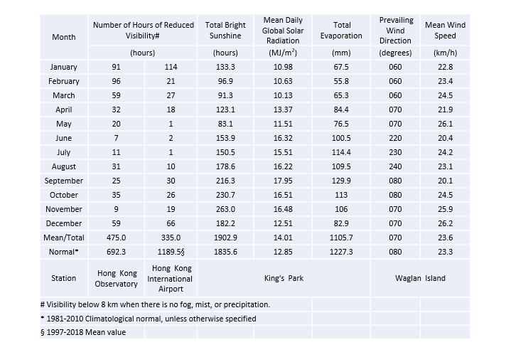
Table 2c Summary of meteorological observations in Hong Kong, 2019