The Year's Weather - 2018
Globally, according to the World Meteorological Organization's preliminary assessment, 2018 is on course to be the fourth warmest year on record. Over the Arctic, sea-ice extent was well below average throughout 2018 and reached record-low levels in the first two months of the year. Various extreme weather events continued to wreak havoc in different parts of the world in 2018, including heatwaves in large parts of Europe, Middle East, North Africa, Japan and the Korean Peninsula, cold spells in parts of Europe and Morocco, severe drought in Uruguay, northern and central Argentina, eastern Australia and large parts of Europe. Extreme rainfall triggered severe flooding and landslides in parts of Europe, East Africa, southwest India and western Japan. High winds, storm surges and torrential rain induced by tropical cyclones brought severe damages and heavy casualties to Tonga, Samoa, the northern Marianna Islands, Yemen, Oman, Florida and North Carolina of the United States, east coast of Madagascar, east coast of India, Kobe and Osaka in Japan, the northern part of the Philippines and Guangdong province of China. High temperature and drought also contributed to destructive wildfires in California of the United States, western Canada, Norway, Sweden, Germany, Greece, Latvia, United Kingdom and Ireland.
A weak and short-lived La Niña event was established in early 2018. Sea surface temperatures of the central and eastern equatorial Pacific warmed and returned to normal in April. The warming trend continued into the second half of the year with temperature of the region exceeding the El Niño threshold in October and remaining above normal through to December.
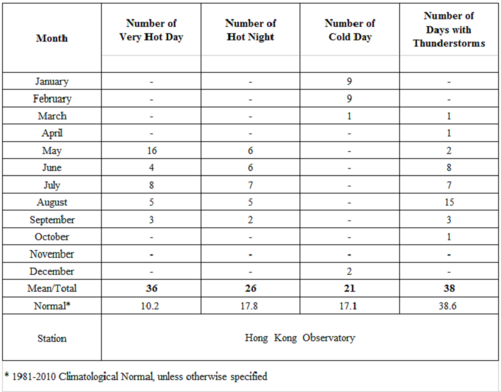
Locally, mainly attributing to the exceptionally warm spring, the weather in Hong Kong was warmer than usual in 2018 with an annual mean temperature of 23.9 degrees, 0.6 degree above the 1981-2010 normal[1] (or 0.9 degree above the 1961-1990 normal) and among the third warmest on record. In particular, the monthly mean temperature of 28.3 degrees for May ranked the highest since records began in 1884. The highest temperature recorded at the Hong Kong Observatory in the year was 35.4 degrees on 30 May, the eleventh highest since records began in 1884. There were 26 Hot Nights[3] and 36 Very Hot Days[2] in Hong Kong in 2018, ranking the eighth highest and the third highest on record respectively.
For low temperatures, the number of Cold Days[4] in the year was 21 days, which is 3.9 days more than the 1981-2010 normal. The lowest temperature recorded at the Hong Kong Observatory in the year was 6.8 degrees on 1 February.
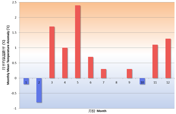
Fig. 1 Monthly mean temperature anomalies in Hong Kong in 2018
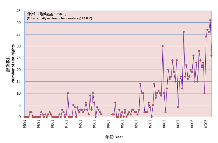
Fig. 2 Long-term time series of number of hot nights in Hong Kong 1884-2018
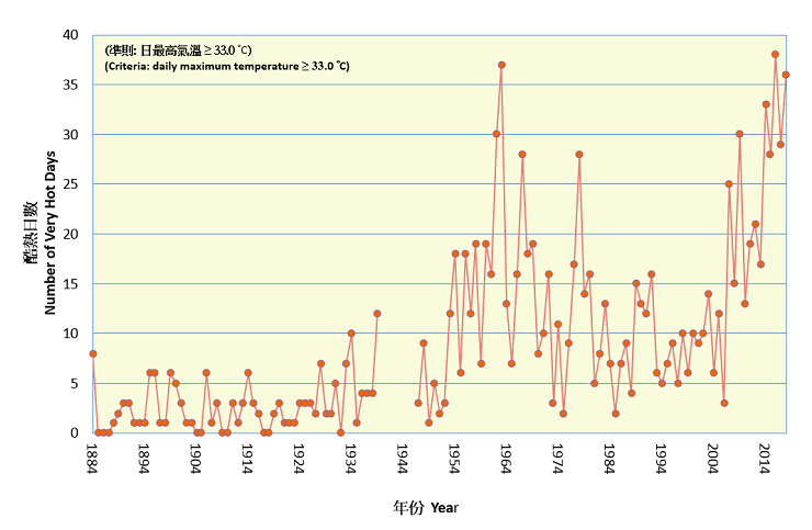
Fig. 3 Long-term time series of number of very hot days in Hong Kong 1884-2018
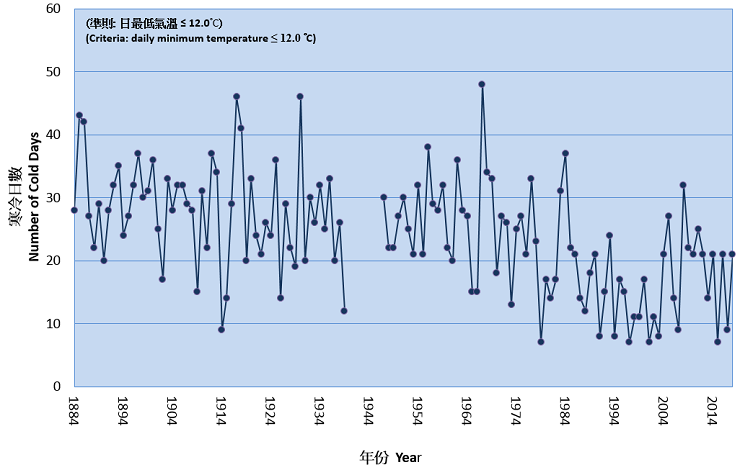
Fig. 4 Long-term time series of number of cold days in Hong Kong 1884-2018
The year 2018 was drier than normal in Hong Kong, mainly due to the well below normal rainfall from February to May. The annual total rainfall was 2162.9 millimetres, a deficit of about 10 percent comparing to the 1981-2010 normal of 2398.5 millimetres (or about 3 percent below the 1961-1990 normal). Four red rainstorm warnings were issued by the Hong Kong Observatory in 2018. There was no black rainstorm warning issued in the year. The number of days with thunderstorms reported in Hong Kong was 38 days in 2018, close to the 1981-2010 normal of 38.6 days.
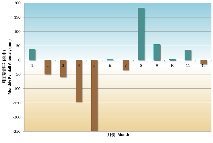
Fig. 5 Monthly rainfall anomalies in Hong Kong in 2018
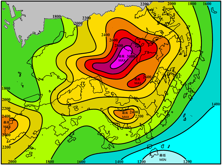
Fig. 6 Annual rainfall distribution (millimetres) in Hong Kong in 2018
A total of 33 tropical cyclones occurred over the western North Pacific and the South China Sea in 2018, more than the long-term (1961-2010) average of 30. There were 13 tropical cyclones reaching typhoon intensity[5] or above during the year, less than the long-term average of about 15, and seven of them reached super typhoon intensity (maximum 10-minute wind speed of 185 km/h or above near the centre). In Hong Kong, six tropical cyclones necessitated the issuance of tropical cyclone warning signals, near the long-term average in a year. The Hurricane Signal No. 10 was issued during the passage of Mangkhut in September, while the No. 3 strong wind signal was issued for five times during the passages of Ewiniar in June, Son-tinh in July, Bebinca in August, Barijat in September and Yutu in November.
Detailed description of the weather for individual months is available on the Monthly Weather Summary webpage:https://www.hko.gov.hk/wxinfo/pastwx/mws.htm
Some significant weather events in Hong Kong in 2018 are highlighted below:
Cold spell from late January to early February
Affected by an intense winter monsoon and its replenishments, cold weather started to affect Hong Kong in late January and persisted till the early part of February, with the lowest temperature of the year, 6.8 degrees, recorded at the Hong Kong Observatory on 1 February and frost being reported in places over the territory during the period as well. Moreover, from 29 January to 6 February, there were 9 consecutive days with daily minimum temperature at the Observatory at or below 10.0 degrees, one of the fourth longest on record.
The Hottest May
Under the dominance of an upper-air anticyclone over the northern part of the South China Sea, Hong Kong experienced an exceptionally hot and dry May with a fine and near rain-free spell starting from 12 May till the end of the month. The monthly mean temperature of 28.3 degrees and monthly mean minimum temperature of 26.1 degrees were 2.4 degrees and 2.0 degrees above their respective normals and were the highest ever on record for May since records began in 1884. There were in total 16 Very Hot Days and 6 Hot Nights in the month, breaking the corresponding highest records for May. The heat wave of 15 consecutive Very Hot Days from 17 to 31 May also set a new record for May. The temperature at the Hong Kong Observatory soared to the year’s highest of 35.4 degrees on 30 May.
The drought from January to May
Mainly attributing to the well below normal rainfall from February to May, the total rainfall in Hong Kong from January to May 2018 was only 175.0 mm, a deficit of 73 percent compared to the normal of 640.8 millimetres and the second lowest record for the same period since records began in 1884.
The ferocious strike of Mangkhut
Severe Typhoon Mangkhut, packing an extensive circulation of storm to hurricane winds and squally heavy rain, skirted past at about 100 kilometres to the south-southwest of Hong Kong on 16 September 2018 and necessitated the issuance of the highest tropical cyclone warning, No. 10 Hurricane Signal, for 10 hours in Hong Kong. This is the second longest duration of No. 10 Hurricane Signal in Hong Kong since 1946, just next to the record of 11 hours set by Typhoon York on 16 September 1999.
Hong Kong was severely battered by the extreme high winds and record breaking storm surge brought by Mangkhut. The maximum 60-minute mean wind speeds recorded at Waglan Island and Cheung Chau were 161 km/h and 157 km/h respectively. Both are the second highest record at the corresponding stations, just below the records set by Ellen in 1983. The severe storm surge brought by Mangkhut raised the water level in Hong Kong generally by more than two metres, resulting in unusually high water level in many places in Hong Kong. The water level at Quarry Bay of the Victoria Harbour rose to a maximum of 3.88 mCD (metres above Chart Datum) on the afternoon of 16 September 2018, the second highest since instrumental water level measurement started in 1954 and only lower than the record high of 3.96 mCD set by Super Typhoon Wanda in 1962. Moreover, the maximum storm surge (i.e. the increase in water level above the astronomical tide) brought by Mangkhut at Quarry Bay was 2.35 m which was the highest since instrumental water level measurement started in 1954, breaking the previous record of 1.77 m kept by Wanda in 1962.
The destructive winds, severe storm surge and squally heavy rain associated with Mangkhut ravaged the city for about half a day, causing the most serious and extensive damages to Hong Kong in the recent three decades since Ellen in 1983. There was serious flooding in many coastal and low-lying areas, substantial damages of coastal structures/buildings, over 60,000 reports of fallen trees, at least 500 reports of smashed windows or glass curtain walls. Electricity supply to over 40,000 households in Hong Kong was interrupted. Power outage to some 13,500 households lasted for more than 24 hours, and the electricity supply to some remote areas and individual buildings were not fully restored even after four days. Supply of fresh water in some places was also affected due to power outage. Hundreds of yachts, dinghies and boats of various sizes were lost, sunk or seriously damaged by the powerful waves. While 458 people were injured during the passage of Mangkhut, there was no fatality. Traffic and transportation services in Hong Kong were also seriously affected on 16 and 17 September 2018 due to flooding, blocking of roads or railways by fallen trees and scaffoldings and damage of pier facilities. 889 flights were cancelled at the Hong Kong International Airport. More details can be found in the tropical cyclone report of Super Typhoon Mangkhut (https://www.weather.gov.hk/informtc/mangkhut18/mangkhut.htm).
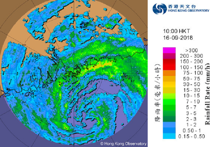
Fig. 7 Image of radar echoes at 10:00 a.m. on 16 September 2018. The intense spiral rainband of Mangkhut was affecting Hong Kong at that time.
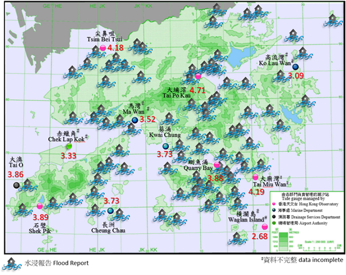
Fig. 8 Maximum sea level (metres above Chart Datum) recorded at various tide gauges in Hong Kong and flood reports from government departments, news and social media on 16 September 2018. The flood reports are not exhaustive.
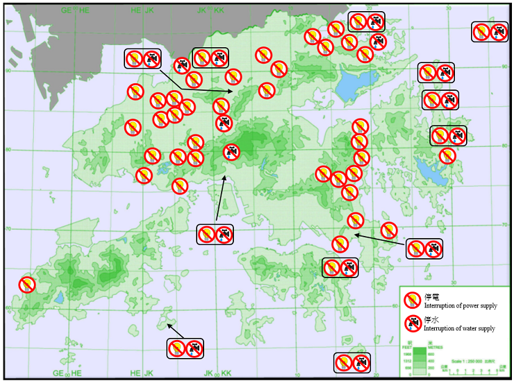
Fig. 9 Reports of interruption of power and water supply under the influence of Mangkhut based on government departments, news and social media. The incident reports are not exhaustive.
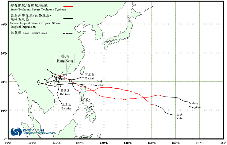
Fig. 10 Tracks of the six tropical cyclones affecting Hong Kong in 2018
Notes :
[1] Climatological normals for the reference period of 1961-1990, 1971-2000 and 1981-2010 are available at : https://www.weather.gov.hk/cis/normal_e.htm.
Climatological normals of 1981-2010 are referenced in the text unless otherwise stated.
[2] 'Very Hot Day' refers to the condition with the daily maximum temperature equal to or higher than 33.0 degrees.
[3] 'Hot Night' refers to the condition with the daily minimum temperature equal to or higher than 28.0 degrees.
[4] 'Cold Day' refers to the condition with the daily minimum temperature equal to or lower than 12.0 degrees.
[5] Information on the classification of Tropical Cyclones is available at: https://www.hko.gov.hk/informtc/class.htm
Table 1 Summary of record-breaking high temperature events in 2018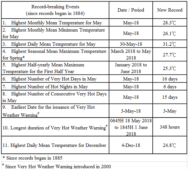
Table 2a Summary of meteorological observations in Hong Kong, 2018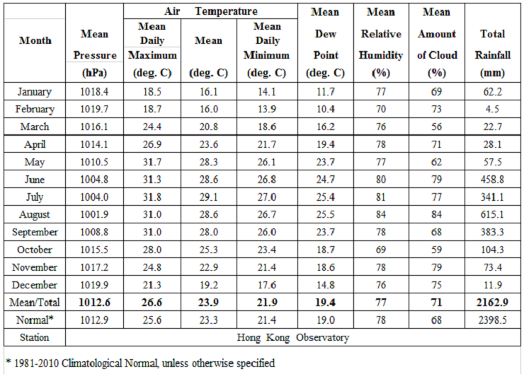
Table 2b Summary of meteorological observations in Hong Kong, 2018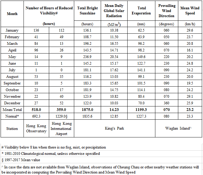
Table 2c Summary of meteorological observations in Hong Kong, 2018