Rainstorm on 7 June 2008
Rainstorm on 7 June 2008
(7 June 2008)
Under the influence of an active trough of low pressure, heavy rain and squally thunderstorms affected Hong Kong today (7 June 2008). Rain was heaviest in the morning. The Observatory recorded 145.5 millimetres during the hour from 8 to 9 a.m., the highest hourly rainfall since record began. From midnight till 6 p.m., 304.8 millimetres of rain fell at the Observatory, the 5th highest daily rainfall record in June.
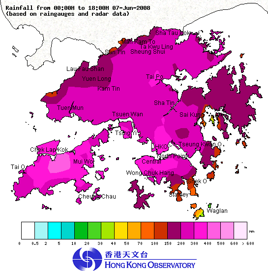
About 200 millimetres of rainfall were recorded generally over Hong Kong today, with those at Lantau Island and urban areas exceeding 300 millimetres. Figure 1 shows the rainfall distribution over Hong Kong today (till 6 p.m.).
This trough of low pressure is expected to weaken, with rain over Hong Kong gradually easing off. There will be sunny periods during the day and some showers in the next few days. For the latest weather forecast, please refer to the following webpages:
http://www.weather.gov.hk/wxinfo/currwx/flw.htm (Local Weather Forecast) and
http://www.weather.gov.hk/wxinfo/currwx/fnd.htm (7-day Weather Forecast)
Up to 6 p.m. today (7 June 2008), the effective times of the warning signals are summarized as follows:
Thunderstorm Warning:
3:55 a.m. to 2 p.m., 7 June 2008
2:40 p.m. to now still in effect
Amber Rainstorm Warning Signal:
5:15 a.m. to 5:55 a.m., 7 June 2008
11:30 a.m. to 1:30 p.m., 7 June 2008
Red Rainstorm Warning Signal:
5:55 a.m. to 6:40 a.m., 7 June 2008
11 a.m. to 11:30 a.m., 7 June 2008
Black Rainstorm Warning Signal:
6:40 a.m. to 11 a.m., 7 June 2008
Landslip Warning:
1:10 a.m. 10 June 2008 to now still in effect

Figure 1. The rainfall distribution in Hong Kong from midnight to 6 p.m. on 7 June 2008.