Rainstorm on 24 April 2007
Rainstorm on 24 April 2007
(24 April 2007)
|
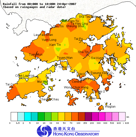
Under the influence of a trough of low pressure, heavy rain and thunderstorms affected Hong Kong this morning (24 April 2007). The Observatory issued the first Amber and Red Rainstorm Warning Signal of the year respectively at 10:15 a.m. and 10:40 a.m. The area of heavy rain moved southwards and rain over the territory began to weaken at around noon. The Observatory issued the Amber Rainstorm Warning Signal to replace the Red Rainstorm Warning Signal at 12:30 p.m. All rainstorm warning signals were cancelled at 1:20 p.m. From the morning till 2 p.m., more than 50 millimetres of rainfall were recorded generally over Hong Kong. The rainfall recorded over the Hong Kong Island, the northern part of the New Territories, Tuen Mun, Tai O and Sha Tin even exceeded 70 millimetres. Rain was heaviest around 10 a.m. to 11 a.m. Figure 1 shows the rainfall distribution over Hong Kong today (till 6 p.m.). The trough of low pressure over the south China coastal region will continue to advance southwards, crossing Hong Kong and bringing thunderstorms to the region tonight (24 April 2007). It is expected to move over the northern part of the South China Sea tomorrow (25 April 2007) when rain over the territory will weaken. For the latest weather forecast, please refer to the following webpages: http://www.weather.gov.hk/wxinfo/currwx/flw.htm (Local Weather Forecast) and http://www.weather.gov.hk/wxinfo/currwx/fnd.htm (7-day Weather Forecast) Up to 6 p.m. today (24 April 2007), the effective time of the warning signals is summarized as follows:- Thunderstorm Warning: 9:15 a.m. to 2:30 p.m., 24 April 2007 4 p.m. and is still in force at 6 p.m., 24 April 2007 Amber Rainstorm Warning Signal: 10:15 a.m. to 10:40 a.m., 24 April 2007 12:30 p.m. to 1:20 p.m., 24 April 2007 Red Rainstorm Warning Signal: 10:40 a.m. to 12:30 p.m., 24 April 2007  Figure 1. The rainfall distribution in Hong Kong from midnight to 6 p.m. on 24 April 2007 |