Waterspout spotted in Hong Kong
Waterspout spotted in Hong Kong (13 August 2005)
|
Severe Tropical Storm Sanvu made landfall at around noon today (13 August 2005) and moved further inland in a northwesterly direction. The outer rain bands of Sanvu brought severe squally thunderstorms to the south China coastal areas. During the thundery showers that began around 4:30 p.m., the Hong Kong Observatory received a report from a marine police constable that a waterspout occurred around 4:50 p.m. near Tai O. The waterspout had a diameter of about 300 metres and a height of 1000 to 1500 metres. At that time the Hong Kong International Airport was affected by thunderstorms, and a gust of 74 kilometres per hour was recorded. The waterspout was also captured by the Observatory's Terminal Doppler Weather Radar (see attached figure). A waterspout occurs over water, and tornado is its equivalent over land. It usually involves a fast rotating column of air extending from the base of a convective cloud to the water surface. A rotating column of air (made visible by cloud droplets) that does not touch the water surface is called a funnel cloud. In Hong Kong, a waterspout was last spotted on 5 July 2005. Waterspouts are most commonly seen in June and July. Since 1959, there were a total of 37 cases of waterspout and 14 cases of funnel cloud sighted within 460 kilometres (250 nautical miles) of Hong Kong. For enquiry , please contact the Observatory duty forecaster at 2926 8477. 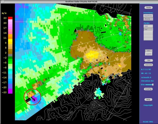 Picture taken by the Terminal Doppler Weather Radar of the Hong Kong Observatory at 4:43 p.m. on 13 August 2005. Enclosed in circle is the location of the waterspout. Purple/blue indicates winds blowing towards the northeast, while orange/yellow indicates winds blowing towards the southwest. Two patches of opposing winds close to one another is the typical pattern of a tornado/waterspout. |