The Very Hot Weather on 19 July 2005
The Very Hot Weather on 19 July 2005 (19 July 2005)
|
Rank |
Maximum temperatures (degrees) |
Date |
|---|---|---|
|
1 |
35.7 |
1968.07.25 |
|
2 |
35.4 |
2005.07.19 |
|
3 |
35.0 |
1980.07.10 |
|
4 |
34.9 |
1958.07.16 |
|
5 |
34.8 |
1982.07.29 |
|
6 |
34.8 |
1986.07.10 |
|
7 |
34.7 |
1972.07.2 |
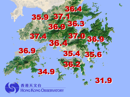
A map showing the maximum temperatures over various parts of Hong Kong today is given in figure 1 below.

Figure 1 Maximum temperature recorded on 19 July 2005 (up to 6pm)
The weather is expected to remain very hot tomorrow (20 July 2005). The maximum temperature in the urban areas will be about 33 degrees and a couple of degrees higher in the New Territories. The public is advised to take appropriate precautions against heatstroke.
For updates on the latest weather report, information on the Very Hot Weather Warning and UV Index, members of the public may browse the Observatory Internet web pages at:
http://www.weather.gov.hk/wxinfo/currwx/current.htm(update weather report);
http://www.weather.gov.hk/wservice/warning/coldhot.htm(Very Hot Weather Warning); and
http://www.weather.gov.hk/wxinfo/uvindex/english/euvtoday.htm(UV Index)
Members of the public who wish to get more information on the prevention of heat stroke can call DH's Central Health Education Unit Hotline at 2833 0111. Information can also be obtained from DH's health educational homepage at http://www.cheu.gov.hk and click "What's New" to obtain a relevant fact sheet.