Rainstorms on 24 June 2005
Rainstorms on 24 June 2005 (24 Jun 2005)
|
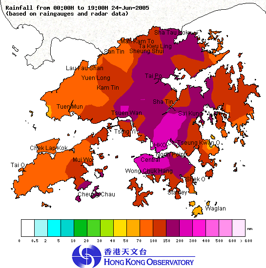
Under the influence of a trough of low pressure, Hong Kong was affected by several episodes of heavy rain this morning (24 June 2005). The Observatory issued the first Red Rainstorm Warning Signal of the year at 10 a.m. today. In the afternoon, the rain area began to move south and weaken gradually. The Red Rainstorm Warning Signal was cancelled at 1:30 p.m. From the early morning till 2 p.m., more than 150 millimetres of rainfall were recorded in many places over the territory. The rainfall recorded in central Kowloon as well as the central and western parts of Hong Kong Island even exceeded 200 millimetres. For the rainfall distribution in Hong Kong today, please refer to the rainfall distribution map below. It is expected that there will still be showers in the next few days. For the latest weather forecast, please refer to the following webpages: Up to 7 p.m. today (24 June 2005), the effective time of the warning signals is summarized as follows:- Thunderstorm Warning: Amber Rainstorm Warning Signal: Special Announcement on Flooding in the northern New Territories: Red Rainstorm Warning Signal: Landlsip warning:  Rainfall distribution in Hong Kong from midnight to 7:00 p.m. on 24 June 2005 |