Squally Thunderstorms on 9 May 2005
Squally Thunderstorms on 9 May 2005 (9 May 2005)
|
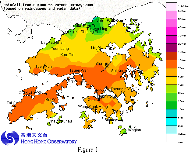
A rainband with embedded intense thunderstorms passed through Hong Kong shortly after noon time on Monday, 9 May 2005. During the passage of the rainband, severe squalls associated with the thunderstorms gave rise to short-lived stormy conditions between 12:15 pm and 12:45 pm, particularly over the western part of the territory. Sustained wind speeds at Kwai Chung were up to about 50 km per hour, with peak gust reaching 135 km per hour. Since the availability of wind data from 1985 for the area, this is the highest gust recorded in a non-tropical cyclone situation. During the heavy rain episode today, Amber Rainstorm Warning was in effect between 12:10 pm and 2:20 pm. Up to 8 pm, rainfall amounts recorded over the territory generally exceeded 60 millimetres (see Fig. 1). Normal rainfall for the first 10 days of May is 73 millimetres. Since 1 May 2005, rainfall recorded in the month so far at the Hong Kong Observatory is about 120 millimetres, i.e. 64% above the normal for early May. A trough of low pressure brought unsettled weather to the south China coastal areas. The trough is forecast to weaken over the next few days, with showers in Hong Kong becoming less frequent and more sunshine expected in the latter part of the week. Squalls or violent gusts often occur with thunderstorms, bringing abrupt increases in wind speed and drastic changes in wind direction. Outdoor structures should be fastened and secured, and loose objects should be brought inside. Drivers using highways and flyovers should be mindful of strong gusts. Small boats on the open sea should also watch out for the approach of squalls accompanying thunderstorms. (For any enquiries, please contact Duty Forecaster at 2926 8473.)
|
