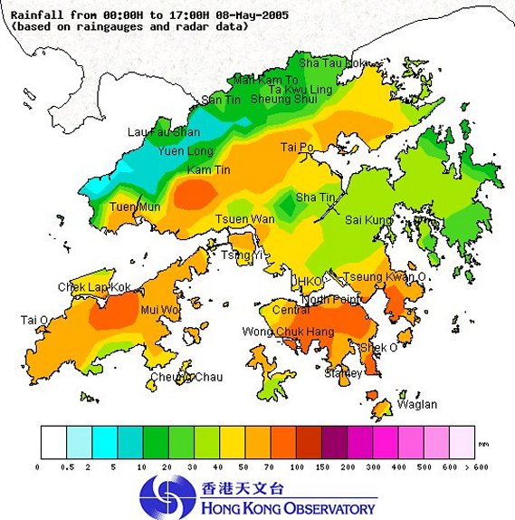
Rainstorms on 8 May 2005
Rainstorms on 8 May 2005
|
The Hong Kong Observatory (HKO) issued in the morning today (8 May 2005) the first Amber Rainstorm Warning Signal and the first Special Announcement on Flooding in the northern New Territories this year. This is the latest issuance of the Amber Rainstorm Warning Signal for the first time of the year since its launch in 1998. An upper-air disturbance swept through Hong Kong in the morning and brought widespread heavy rain and squally thunderstorms to the territory. Initially, heavy rain affected mainly the New Territories and the Special Announcement on Flooding in the northern New Territories was issued at 10:10 a.m. As the area of heavy rain shifted southwards and became more widespread, the Amber Rainstorm Warning was issued at 10:35 a.m. More than 30 millimetres of rainfall were recorded generally over the territory this morning. The heaviest rain fell in Hong Kong Island, Tseung Kwan O, Tung Chung and Yuen Long region where more than 70 millimetres of rainfall were recorded. Rain weakened in the early afternoon and the Special Announcement on Flooding in the northern New Territories and the Amber Rainstorm Warning were cancelled at 12:10 p.m. and 2:00 p.m. respectively. A rainfall distribution map up to 5:00 p.m. today (8 May 2005) is attached. The effective timing of the warning signals (up to 5:00 p.m.) is summarized below :
For the latest weather forecast, please refer to the following webpages: http://www.weather.gov.hk/wxinfo/currwx/flw.htm (Local Weather Forecast) and
|
