|
The pressure over northern China is rising. The associated northeast monsoon is forecast to reach the Guangdong area later tomorrow (Friday, 1 October 2004)
With the arrival of the winter monsoon in south China coastal region tomorrow night (Friday, 1 October 2004), winds in Hong Kong will freshen from the north, cloud amount will increase with some rain. However, there should not be significant impact on the National Day Fireworks Display tomorrow night (Friday, 1 October 2004).
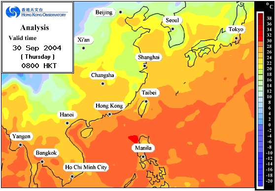
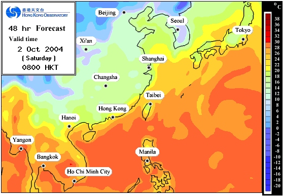
This northeast monsoon is expected to bring cooler weather to south China coastal region over the weekend and early next week. According to the Observatory's computer model forecast surface temperature distribution maps (Figures 1 and 2), temperatures over the Pearl River Estuary will generally drop to around 20-22 degrees on Saturday morning (2 October 2004).
The Hong Kong Observatory reminds the public to take note of the weather changes. For the latest weather information and 7-day Weather Forecast, please check the following Internet web pages of the Hong Kong Observatory:
Local weather forecast http://www.weather.gov.hk/wxinfo/currwx/flw.htm
Regional Weather http://www.weather.gov.hk/wxinfo/currwx/current.htm
7-Day Weather Forecast http://www.weather.gov.hk/wxinfo/currwx/f5d.htm

Figure 1 : The Observatory's Computer Model analyzed surface temperature distribution map valid at 8 a.m. on 30 September 2004 (Thursday).

Figure 2 : The Observatory's Computer Model forecast surface temperature distribution map valid at 8 a.m. on 2 October 2004 (Saturday).
|