Rainstorms on 8 May 2004
Rainstorms on 8 May 2004 (8 May 2004)
|
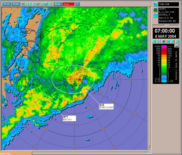
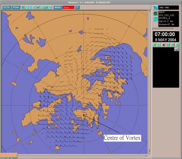
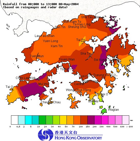
The Hong Kong Observatory (HKO) issued the first Red and the first Black Rainstorm Warning Signals of the year this morning (Saturday, 8 May 2004). The previous Red was issued on 5 May 2003 while the previous Black was issued on 1 September 2001. An upper-air disturbance swept through Hong Kong this morning and brought widespread heavy rain and squally thunderstorms to the territory. The Hong Kong Observatory issued the Amber Rainstorm Warning Signal at 4:10 a.m. today (8 May 2004). As heavy rain intensified and became more widespread, the Red Rainstorm Warning Signal was issued at 6:40 a.m. When the upper-air disturbance moved across Hong Kong, it manifested itself as a vortex which was clearly captured by the HKO Weather Radar's high resolution display (Figure 1 and Figure 2). The vortex induced rapid intensification of the rainstorm, necessitating the issuance of the Black Rainstorm Warning Signal at 7:20 a.m. As the area of torrential rain associated with the vortex moved eastwards, the Signal was then replaced by the Red Rainstorm Warning Signal at 8:00 a.m. Rain continued to weaken in the late morning and the Red Signal was subsequently replaced by the Amber Signal at 10:15 a.m. As the band of heavy rain cleared Hong Kong, the Amber Rainstorm Warning Signal was cancelled at 11:00 a.m. The heavy downpour brought more than 100 millimetres of rainfall to the urban areas, and parts of the New Territories. Rainfall of more than 150 mm were recorded in Lantau Island, Kwai Tsing and Sai Kung. A map showing the rainfall distribution over the territory up to 1 p.m. today is attached in Figure 3 .
Up to 1 p.m. today (8 May 2004), the effective time of the warning signals is summarized as follows : Amber Rainstorm Warning Signal : Red Rainstorm Warning Signal : Black Rainstorm Warning Signal : Thunderstorm Warning : For the latest weather forecast, please refer to the following webpages:
Figure 1: An image captured by the Observatory's weather radar at 7 a.m. on 8 May 2004. It shows a band of heavy rain affecting Hong Kong and its vicinity. The Red Rainstorm Warning was in force then. Figure 2: Wind pattern (3 km above mean sea level) showing a vortex over Hong Kong Island, as derived from Doppler wind information obtained with the Tai Mo Shan and Tate's Cairn weather radars. Figure3: Rainfall distribution in Hong Kong from midnight to 1:00 p.m. on 8 May 2004. |


