The Observatory's satellite image gallery on web
The Observatory's satellite image gallery on web (29 November 2002)
|
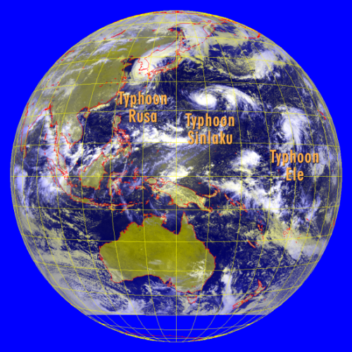
Starting from today (29 November 2002), members of the public will be able to view on the Hong Kong Observatory website a new satellite image gallery. Apart from the purpose of public education, the gallery aims at heightening public awareness towards disaster preparedness. The gallery presents typical satellite images taken over the Asia-Pacific region. The topics include calamities such as typhoons, severe floods and duststorms, as well as other interesting phenomena such as fog banks, hill fires and extent of urbanization in southern China. The images have been specially computer-processed to bring out these features. An example of a satellite image on the gallery is given in the attached, which depicts three typhoons in a row over the western North Pacific in late August 2002. You are welcome to visit the gallery at: http://www.weather.gov.hk/wxinfo/intersat/satellite_gallery/index_e.htm The Observatory receives new satellite images every day. These images can be viewed at: http://www.weather.gov.hk/wxinfo/intersat/satpic_s.shtml
Satellite picture captured on 31 August 2002 showing Typhoon Rusa in the west, near the Korean Peninsula, followed by Typhoons Sinlaku and Ele further to the east over the western North Pacific. All of them packed winds exceeding 118 km/h. The tendency for tropical cyclones in 2002 to develop further to the east of the western North Pacific, and subsequently track over that part of the ocean, resembles the behaviour of tropical cyclones in typical El Nino years. (The image was originally captured by GMS-5 of Japan Meteorological Agency) |
