Rainstorms on 9 August 2002
Rainstorms on 9 August 2002 (9 August 2002)
|
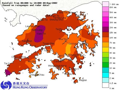
An active trough of low pressure over the south China coast brought heavy rain and squally thunderstorms to Hong Kong today (Friday, 9 August 2002). The Hong Kong Observatory issued the Amber Rainstorm Warning Signal and the Special Announcement of Flooding in Northern New Territories. In the morning, rain was particularly heavy over the northwestern part of the New Territories where more than 100 millimetres of rainfall were generally recorded. The rain was heaviest in Yuen Long where more than 150 millimetres of rainfall were registered. Rain then became heavy over the southeastern part of Hong Kong Island, which had about 100 millimetres of rainfall in the afternoon. A rainfall distribution map for today (up to 6 p.m.) is attached.
The effective time of the warning signals issued today (up to 6 p.m.), is summarized as follows: Special Announcement of Flooding in Northern New Territories: 7:30 a.m. to 10:45 a.m. The active trough of low pressure will continue to affect the south China coast tomorrow and the weather is expected to remain unsettled with occasional heavy rain and thunderstorms. For the latest weather forecast, please refer to the following webpages: |
