Haze on 15 September 2001
Haze on 15 September 2001 (15 September 2001)
|
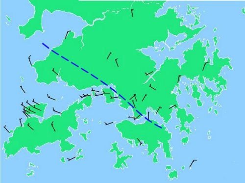
It was hazy in Hong Kong today. The visibility was reduced to below 5000m over most parts of Hong Kong this morning. The visibility even fell below 2000m around noon near Chek Lap Kok. The anticyclone over northern China and the tropical cyclone Nari over the East China Sea together caused generally light northerly air flow over southern China. In Hong Kong, winds were generally light northerly. Solar heating during the day resulted in the setting in of sea breezes, causing some local convergence of air over the territory (see attached figure ) which prevented the dispersion of suspended particulates in the air, resulting in rather low visibility. For the next couple of days, winds are expected to remain light and mainly from the north. It will continue to be hazy with rather low visibility. Apart from a few isolated showers, the weather will be mainly fine. 
For the latest weather forecast, please refer to the following web pages: http://www.weather.gov.hk/wxinfo/currwx/flw.htm (local weather forecast) and http://www.weather.gov.hk/wxinfo/currwx/f5d.htm (5-day weather forecast). |