Typhoon Utor
Typhoon Utor (06 JUL 2001)
|
Utor formed as a tropical depression over the western Pacific on Sunday, 1 July. It intensified into a typhoon on Tuesday, 3 July. Utor later skirted the northern coast of Luzon and entered the South China Sea in the evening of Wednesday, 4 July. In Hong Kong the Standby Signal No. 1 was hoisted at 5:45 p.m. on 4 July. Typhoon Utor then moved steadily northwestwards towards the coast of Guangdong at a fast speed of 35 kilometres per hour. The Hong Kong Observatory hoisted the Tropical Cyclone Signal No. 3 and No. 8 at 10:45 a.m. and 7:30 p.m. respectively on Thursday, 5 July. As it approached the coast of Guangdong, it slowed down to a speed of about 20 kilometres per hour and weakened into a severe tropical storm. Utor made landfall near Shanwei this morning (Friday, 6 July). Utor weakened further after making landfall, but tracked generally westwards skirting Hong Kong within 100 kilometres to the north.
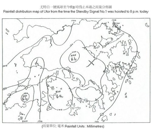
Utor brought widespread squally rainstorms to Hong Kong. From the time the Standby Signal No. 1 was hoisted to 8 p.m. today, 100 to 200 millimetres of rainfall were recorded in most places locally. The heaviest downpour occurred at Lantau Island where more than 260 millimetres of rain were recorded. A rainfall distribution map is attached. The Amber Rainstorm Warning was issued at 12:30 p.m. and the Landslip Warning was issued at 6:00 p.m. The high winds and low pressure of Utor also brought storm surge (i.e. abnormal sea level rise above normal astronomical tides) to Hong Kong. Coupled with the astronomical high tide occurring this morning, high sea level resulted in the inundation of low-lying coastal areas this morning. The sea level was 3.6 metres and 3.4 metres at Tsim Bei Tsui and Quarry Bay respectively around 9 to 10 a.m. this morning. The reading at Quarry Bay is the highest sea level recorded in Victoria Harbour since Typhoon Wanda in 1962. According to records of the Observatory, there were a total of 13 occasions in which the sea level at Quarry Bay was higher than 3 metres since 1947. Utor will continue to weaken as it moves across Guangdong. However, its remnant will continue to bring heavy rain to Hong Kong tomorrow (7 July). For the latest weather forecast, please refer to the following web sites: http://www.weather.gov.hk/wxinfo/currwx/flw.htm (local weather forecast),and http://www.weather.gov.hk/wxinfo/currwx/f5d.htm (5-day forecast). |