The Rainstorm on 12 June 2001
The Rainstorm on 12 June 2001 (12 June 2001)
|
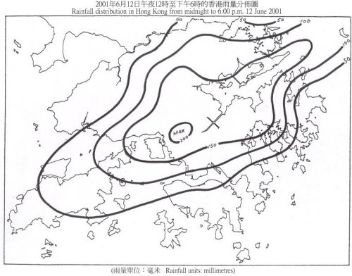
The trough of low pressure over the south China coast continued to bring heavy rain to Hong Kong today (Tuesday, 12 June 2001), and the Observatory issued both the Amber and Red Rainstorm Warning Signals. This is the 8th consecutive day that Rainstorm Warning Signal had been issued, the longest period on record since the revised Rainstorm Warning System was operational in 1998. According to past records, the Observatory also issued the Rainstorm Warning Signal for 4 consecutive days on 22 to 25 August 1999 and 1 to 4 August 2000. The heavy rain today affected many areas in the New Territories and Kowloon. More than 160 millimetres of rainfall were recorded in Tsuen Wan, Sha Tin, Sai Kung and the northern part of Kowloon. In Tai Po and Kwai Chung, rainfall amount exceeded 180 and 200 millimetres respectively. A rainfall distribution map for today is shown below. From 1 June up to 6 p.m. today, 567.0 millimetres of rainfall were recorded at the Hong Kong Observatory. This is the 5th highest rainfall amount for the same period (1 to 12 June) on record. The four years with the highest rainfall amount for the same period are 1966 (766.0 millimetres), 1885 (697.6 millimetres), 1916 (680.2 millimetres) and 1998 (640.5 millimetres). Up to 6 p.m., the effective time of the warning signals today is summarised as follows : Amber Rainstorm Warning Signal : Red Rainstorm Warning Signal : Landslip Warning: Thunderstorm Warning : Meanwhile, a trough of low pressure over central China will move southwards gradually and affect the south China coastal areas in the next couple of days. In Hong Kong, there will be occasionally heavy rain with squally thunderstorms tomorrow. For the latest weather forecast, please refer to the following webpages: http://www.weather.gov.hk/wxinfo/currwx/flw.htm (local weather forecast) and  Rainfall distribution in Hong Kong from midnight to 6:00 pm 12 June 2001 |