The Rainstorm on 8 June 2001
The Rainstorm on 8 June 2001 (8 June 2001)
|
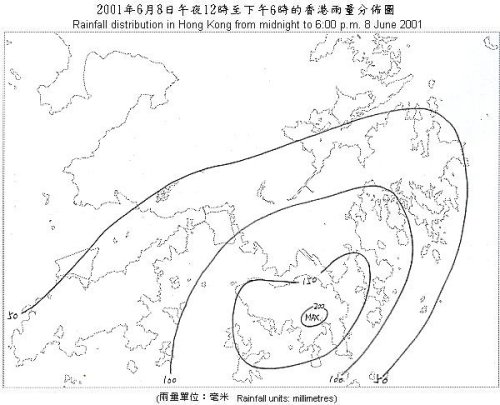
A trough of low pressure over the south China coast continued to bring heavy rain to Hong Kong today (Friday, 8 June 2001). It is the 4th consecutive day that the Amber Rainstorm Warning Signal was issued, the first time in June on record. The Red Rainstorm Warning Signal was also issued. The heavy rain occurred mainly in the urban areas with over 100 millimetres of rainfall. In Hong Kong Island and the Eastern part of Kowloon, rainfall exceeded 150 millimetres. The heaviest downpour occurred in Hong Kong Island where over 200 millimetres were recorded. A rainfall distribution map for today is shown below. Up to 6 p.m. today, 130.5 millimetres of rainfall were recorded at the Hong Kong Observatory. The 4-day total since 5 June is 331.1 millimetres. This is the second highest 4-day rainfall in June during the past 10 years. The highest 4-day total rainfall in June during the past 10 years is 533.2 millimetres, recorded from 8 to 11 June 1998. Up to 6 p.m., the effective time of the warning signals today is summarised as follows : Amber Rainstorm Warning Signal : 4:25 a.m. to 8:20 a.m. 2:15 p.m. to 4:30 p.m. Red Rainstorm Warning Signal : 8:20 a.m. to 2:15 p.m. Landslip Warning: 7:45 a.m. to 5:00 p.m. Thunderstorm Warning : 11:30 p.m. 6 June to 6:00 p.m. 8 June The weather tomorrow is expected to remain unsettled with occasional rain, heavy at times with thunderstorms. For the latest weather forecast, please refer to the following webpages: http://www.weather.gov.hk/wxinfo/currwx/flw.htm (local weather forecast) and  Rainfall distribution in Hong Kong from midnight to 6:00 pm 8 June 2001 |