Dust storms / Fire / Volcanic ash
|
Dust storms / Fire / Volcanic ash | |
|
16 January 2005 | |
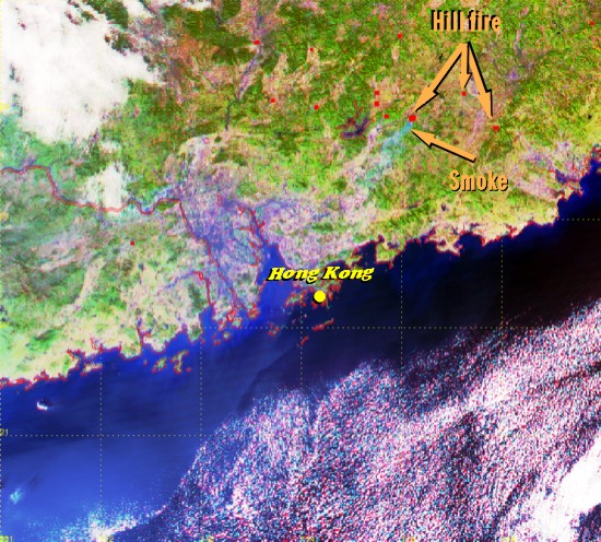 |
Hill fire broke out in inland Guangdong on 16 January 2005. The red spots in the satellite image depicted suspected locations of the fire. Smoke, in bluish colours, was seen blowing off an area of hill fire towards the southwest to the Pearl River Delta. In Hong Kong, visibility of as low as 4500 metres was observed in parts of the territory. |
|
Image time - 1:13 p.m., 16 January 2005 The satellite image, which was captured by EOS AQUA satellite, was specially processed using channels 1, 2 and 6, with assignment of colours to bring out features of special interest. Major features appearing on the image include river/lake/reservoir (blue), vegetation (green) and developed area (purple). Satellite data are also processed to locate regions (appearing as red spots) with higher temperatures to indicate where hill fire may have occurred. To know more about weather satellites, please refer to the Notes. | |
|
Dust storms / Fire / Volcanic ash | |
|
30 October 2004 and 1 November 2004 | |
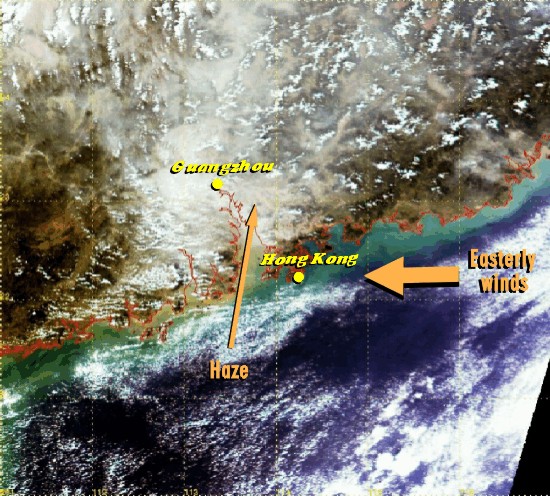 |
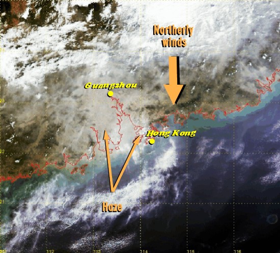
An easterly airstream prevailed over Hong Kong on 30 October 2004, holding off the haze to the northwest. Visibility in Hong Kong was over 10 kilometres. With winds turning from easterlies to northerlies on 1 November 2004, haze spread south to cover Hong Kong. Visibility in Hong Kong dropped below 10 kilometres, reaching a low of 3000 metres in the western part of the territory. |
|
Image time - 11:32 a.m., 30 October 2004 The true colour image was captured by EOS TERRA satellite. This was generated by combining the satellite data from channels 1, 3 and 4. The image likens the view as seen by naked eyes from space. To know more about weather satellites, please refer to the Notes. | |
 |
|
|
Image time - 11:20 a.m., 1 November 2004 The true colour image was captured by EOS TERRA satellite. This was generated by combining the satellite data from channels 1, 3 and 4. The image likens the view as seen by naked eyes from space. To know more about weather satellites, please refer to the Notes. | |
|
Dust storms / Fire / Volcanic ash | |
|
25 September 2002 | |
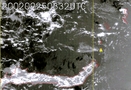 |
Ruang Volcano, Indonesia, erupted in the morning of 25 September 2002. In the sequence of satellite images shown here, the location of volcano is marked by a yellow triangle. Under the influence of winds prevailing at the time, the ash dispersed in a generally westward direction. |
|
Visible image animation from 11:32 a.m. to 4:32 p.m. on 25 September 2002. | |
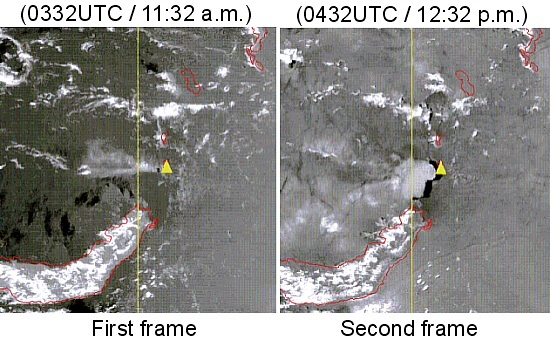 |
The first frame of the sequence shows ash from an earlier eruption, which occurred in the small hours that morning. The ash did not rise very high, only to about 2 km. The second frame as well as subsequent images, however, show a major eruption. It sent volcanic ash to a height of 15 km. |
|
Image time - 11:32 a.m. and 12:32 p.m., 25 September 2002 The visible satellite images were captured by GMS-5. To know more about weather satellites, please refer to the Notes. | |
|
Dust storms / Fire / Volcanic ash | |
|
4 December 2002 | |
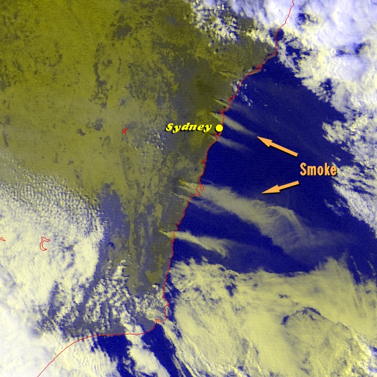 |
New South Wales, Australia experienced one of the most violent wildfires for many years. Persistent dry weather in late 2002 has brought severe drought to New South Wales. The satellite picture spotted many sources of smoke from fires north and south of Sydney. According to the news, the fires forced many residents to evacuate their homes. |
|
Image time - 1:32 p.m., 4 December 2002 The satellite image, which was captured by GMS-5, was specially processed using VIS and IR1 channels, with assignment of colours to bring out features of special interest. Major features appearing on the image include smoke or low clouds (grayish yellow) and deep clouds (white). To know more about weather satellites, please refer to the Notes. | |
|
Dust storms / Fire / Volcanic ash | |
|
8 April 2002 | |
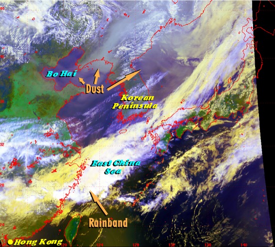 |
The satellite image shows widespread dust affecting northeastern China, Bo Hai, the Korean Peninsula and the sea to its east. It appears as a hazy, grayish patch on the image. At that time, there was an extensive rainband over the East China Sea and the southeastern part of China. This rainband had the effect of washing out any dust moving southward. |
|
Image time - 1:14 p.m., 8 April 2002 The satellite image, which was captured by NOAA-16, was specially processed using channels 1, 2 and 4, with assignment of colours to bring out features of special interest. Major features appearing on the image include dust (hazy gray), deep clouds (white), low clouds (pale yellow), high clouds (blue) and vegetation (green). To know more about weather satellites, please refer to the Notes. | |
|
Dust storms / Fire / Volcanic ash | |
|
21 March 2002 | |
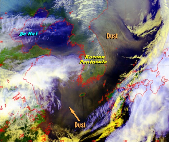 |
Regions across the East China Sea and the Korean Peninsula were covered by widespread dust. It originated several days earlier from Xinjiang and Nei Mongul. The dust appears as a hazy, grayish patch on the satellite image. |
|
Image time - 1:08 p.m., 21 March 2002 The satellite image, which was captured by NOAA-16, was specially processed using channels 1, 2 and 4, with assignment of colours to bring out features of special interest. Major features appearing on the image include dust (hazy gray), deep clouds (white), low clouds (pale yellow), high clouds (blue) and vegetation (green). To know more about weather satellites, please refer to the Notes. | |
|
Dust storms / Fire / Volcanic ash | |
|
27 November 2001 | |
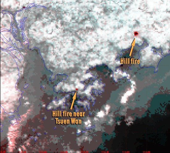 |
The weather was very dry over southern China on 26 and 27 November 2001, with the relative humidity in Hong Kong dropping to about 50 percent. Many hill fires were reported on these two days. The red and dark spots in the figure indicate the locations of hill fire. One was spotted near Tsuen Wan, Hong Kong. The observation of hill fires is made possible by a special observational channel onboard the satellite which is particularly sensitive to variations in surface temperatures. |
|
Image time - 7:30 p.m., 27 November 2001 The satellite image, which was captured by NOAA-15, was specially processed using channels 3B and 4, with assignment of colours to bring out features of special interest. Major features appearing on the image include hill fire (red to dark spots) and clouds (white). To know more about weather satellites, please refer to the Notes. | |
|
Dust storms / Fire / Volcanic ash | |
|
10 August 2000 | |
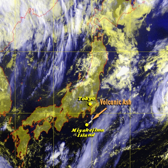 |
Miyakejima Volcano on an island 150 kilometres south of Tokyo erupted in the early morning of 10 August 2000. Some of the emitted volcanic ash was sent to great heights in the atmosphere. The image was captured by GMS-5. The volcanic ash appears as a short white tail and is heading in a general northeastward direction. |
|
Image time - 7:30 a.m., 10 August 2000 The satellite image, which was captured by GMS-5, was specially processed using VIS and IR1 channels, with assignment of colours to bring out features of special interest. Major features appearing on the image include ash (white), deep clouds (white), high clouds (light blue), low clouds (pale yellow), land (yellowish green) and sea (dark). To know more about weather satellites, please refer to the Notes. | |