Heavy rain / Flood
|
Heavy rain / Flood
| |
|
30 June 2004 and 4 July 2004 | |
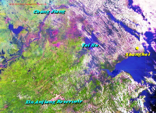 |
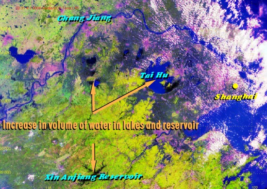
Tropical Storm Mindulle skirted along the coast of Eastern China in early July 2004, bringing torrential rain to that region. The resulting increase in volume of water in Tai Hu and Xin Anjiang Reservoir (in blue colour) was clearly evident by comparing the two high-resolution satellite images, one taken before Mindulle and one after. |
|
Image time - 10:55 a.m., 30 June 2004 The satellite image, which was captured by EOS TERRA satellite, was specially processed using channels 1, 2 and 6, with assignment of colours to bring out features of special interest. Major features appearing on the image include river/lake/reservoir (blue), vegetation (green) and developed area (purple). To know more about weather satellites, please refer to the Notes. | |
 |
|
|
Image time - 10:31 a.m., 4 July 2004 The satellite image, which was captured by EOS TERRA satellite, was specially processed using channels 1, 2 and 6, with assignment of colours to bring out features of special interest. Major features appearing on the image include river/lake/reservoir (blue), vegetation (green) and developed area (purple). To know more about weather satellites, please refer to the Notes. | |
|
Heavy rain / Flood | |
|
18 October 2002 | |
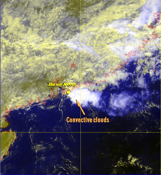 |
Autumnal weather in Hong Kong is usually dry with plenty of sunshine. 18 October 2002, however, was an exception. In the morning that day, a very localized rainstorm hit Hong Kong, while the weather over the rest of southern China and the northern part of the South China Sea remained generally fine. Dumping more than 200 millimetres over the eastern part of the territory, the heavy rain necessitated the issuance of the Red Rainstorm Warning, the latest in a year since the introduction of the Rainstorm Warning System in 1992. On the satellite image, the storm was easily discernible as a bright patch of clouds east of Hong Kong. |
|
Image time - 10:32 a.m., 18 October 2002 The satellite image, which was captured by GMS-5, was specially processed using VIS and IR1 channels, with assignment of colours to bring out features of special interest. Major features appearing on the image include thick clouds (white), low clouds (yellow), land (yellowish green) and sea (dark). To know more about weather satellites, please refer to the Notes. | |
|
Heavy rain / Flood
| |
|
27 August 2002 | |
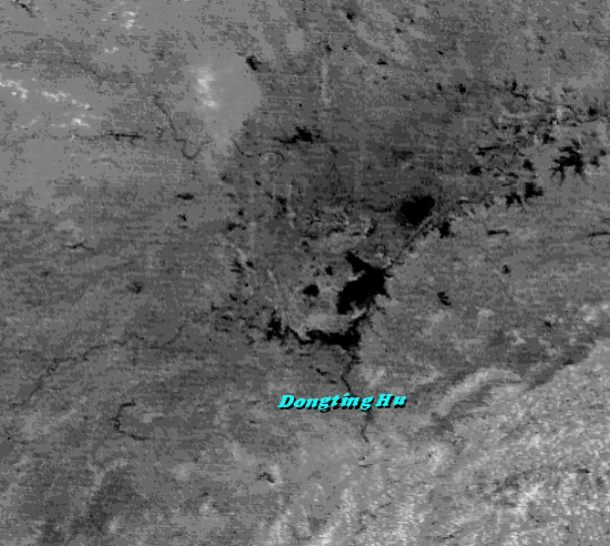 |
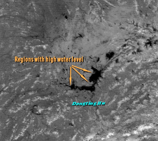
The Hunan Province in central China was hit by torrential rain in August 2002. The increase in the size of Dongting Hu was evident by comparing these two pictures, one taken before the floods and one after. |
|
Image time - 11:32 a.m., 31 May 2002 The visible satellite image was captured by GMS-5. Water bodies appear black in the image. To know more about weather satellites, please refer to the Notes. | |
 |
|
|
Image time - 11:32 a.m., 27 August 2002 The visible satellite image was captured by GMS-5. The lake was swollen with flood waters. To know more about weather satellites, please refer to the Notes. | |
|
Heavy rain / Flood | |
|
26 September 2000 | |
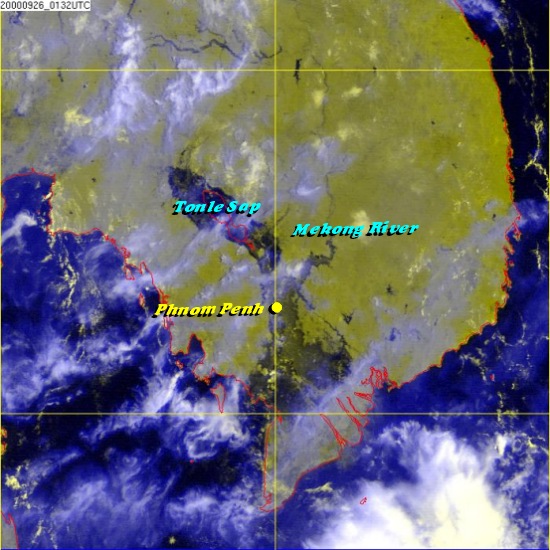 |
In September 2000, disastrous floods afflicted the northeastern part of Thailand, the Mekong River Delta in Vietnam, southern Laos and Cambodia. Caused by unusually heavy monsoon rain, the floods were among the most disastrous hitting the region in recent decades. On the satellite image, the flooded areas over Tonle Sap and Phnom Penh in Cambodia appear in dark colour.
|
|
Image time - 9:30 a.m., 26 September 2000 The satellite image, which was captured by GMS-5, was specially processed using VIS and IR1 channels, with assignment of colours to bring out features of special interest. Major features appearing on the image include flooded areas (dark), clouds (white), land (yellowish green) and sea (dark). To know more about weather satellites, please refer to the Notes. | |