SEISMOLOGICAL MEASUREMENTS IN HONG KONG
Introduction
Information on destructive earthquakes is of general interest and in particular required by engineers when choosing sites for major projects such as dams and power stations. Seismic data are also used by structural engineers in the design of earthquake resistant buildings.
To the east of Hong Kong, the well known circum-Pacific seismic belt passes through Taiwan and the Philippines. Earthquakes occurring there in the past were too far away to affect Hong Kong significantly although on a few occasions local residents felt the tremors. In the history of Hong Kong the only earthquake which was known to have caused some damage was the Shantou earthquake of 1918 which was estimated to reach intensity VII on the Modified Mercalli Scale in Hong Kong. Continuous monitoring of earthquakes is required to obtain data which may be analysed to evaluate the design parameters required by engineers.
The Hong Kong Observatory started operating a set of 3-component long-period seismographs in 1921 to detect distant earthquakes. A network of three short-period seismograph stations was established in 1979 to monitor local earthquakes. In 1997, it was upgraded to an advanced digital network consists of eight stations.
Since 1977, the Observatory has also operated 3-component strong motion accelerographs at different sites, to measure earth movement associated with severe earthquakes which might cause conventional seismographs to go off-scale. These instruments are triggered to start recording when the ground acceleration exceeds a specified threshold.
Earthquake Monitoring
Seismic waves released by an earthquake consist of a spectrum of different frequencies. The high frequency waves tend to be absorbed by the media more quickly than low frequency components. Hence, high frequency waves are not easily detected by sensors placed at distant locations from the epicentre. Short-period seismographs designed to respond to high frequencies are used to detect local or nearby earthquakes. Long-period seismographs which respond to low frequencies are designed to record seismic waves from distant origins.
(a) Monitoring Distant Earthquakes
A set of 3-component long-period seismographs with a smoke paper type recorder was used by the Observatory for direct visual observation from 1921 onwards. An underground cellar was constructed inside the compound in 1923 to accommodate the instruments. The first felt earthquake recorded by the instruments occurred at 1045 local time on 10 January 1924.
During the Second World War, the original seismographs were lost and no observations were made between 1941 and 1950. Recording resumed in 1951 with another set of 3-component long-period seismographs and records were made photographically using mirror galvanometers. The operation of this set of seismographs terminated in 1976.
As part of the programmes for the International Geophysical Year, a set of 3-component long-period seismographs was set up in 1958 in a cooperative experiment with the Lamont-Doherty Geological Observatory of Columbia University, U.S.A. In 1979, the Observatory acquired electronic recording equipment for the seismometers and photographic recording was replaced by the pen-and-ink type.
In 1963, a set of 3-component long-period seismographs and another set of 3-component short-period seismographs from the U.S. Geological Survey (USGS) were installed in Hong Kong to form part of the U.S. Worldwide Standardised Seismograph Network (WWSSN). The combined use of long-period and short-period seismographs enabled a broader spectrum of seismic waves to be studied and more geophysical information to be extracted.
The long-period seismographs detect large earthquakes all over the world. Whenever a significant event is recorded, the first arrival time of the seismic waves is determined and passed to Pacific Tsunami Warning Center (PTWC) , Alaska Tsunami Warning Center (ATWC), Japan Meteorological Agency (JMA) and National Earthquake Information Center (NEIC). With data collected from other stations, these centres compute the location and magnitude of the earthquakes and disseminate these results.
When a major earthquake has occurred, the Hong Kong Observatory issues press releases to inform the public.
(b) Monitoring Local Earthquakes
In recent years, there are considerable interest in local and regional seismicity. The occurrences of disastrous earthquakes in China, such as the Tangshan earthquake in 1976, heighten the awareness of the need to take seismic risk into account in engineering studies.
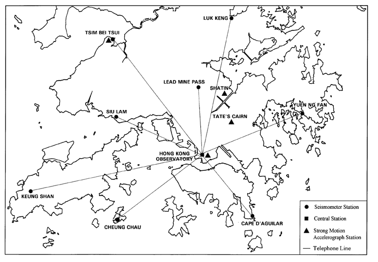
In order to monitor in greater details the location and magnitude of earthquakes near Hong Kong, a network of three short-period seismographs was installed in 1979. It was upgraded to an advanced digital network with eight stations in 1997. These stations are located at Cape D'Aguilar, Cheung Chau, Keung Shan, Lead Mine Pass, Luk Keng, Siu Lam, Tsim Bei Tsui and Yuen Ng Fan (see Figure 1). These sites are located in various parts of Hong Kong so that sufficiently long baselines are available for the computation of epicentral positions. These locations have to be relatively "quiet" in terms of background seismic noise and offer good security to the equipment.
The seismometers used in all eight stations are piezoelectric sensors which provide velocity and acceleration outputs. Three components sensors are deployed at Tsim Bei Tsui and Yuen Ng Fan, the rest have single vertical component only. Except Tsim Bei Tsui, the seismometer at each station is located within a seismic pit consisting of a plastic tube set into concrete on bedrock wherever possible. At Lead Mine Pass and Keung Shan, the seismometers are deployed in boreholes of depth 24 and 33 metres respectively to improve signal-to-noise conditions.
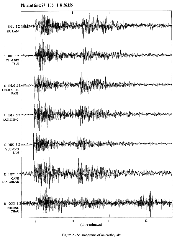
Signals from the seismometers are digitised at the stations at a rate of 75 samples per second and then transmitted to an acquisition computer at the Hong Kong Observatory Headquarters through telephone lines. The computer collects and archives samples which are time-stamped from a GPS-synchronised clock. Should the amplitude of the signals for certain selected stations exceed specific thresholds, the seismic signals of all the stations for the event would be automatically transferred to two computer workstations for further analysis. Epicentral parameters and magnitude of the tremor can then be readily calculated. A sample of the seismograms of an earthquake recorded by the monitoring network on 16 January 1997 is shown in Figure 2. Its epicentre was about 720 km to the east of the Hong Kong Observatory. From 1979 to 1996, a total of 34 felt earthquakes was detected averaging about two events a year.
The Strong Motion Accelerograph Network
When severe tremors are experienced, seismographs are violently deflected and go off-scale. Important information such as the maximum ground acceleration of the event required by engineers for damage analysis and future building design is therefore lost. To cover this eventuality, two 3-component strong motion accelerographs were installed in 1977 at Tate's Cairn and the cellar of the Hong Kong Observatory's Headquarters. The network is further expanded in 1997 by the addition of three more accelerographs on the roof-top of the Centenary Building at the Hong Kong Observatory Headquarters, on reclaimed land at Sha Tin and on concrete plinth at Tsim Bei Tsui respectively (see also Figure 1). Records obtained by these accelerographs can be retrieved easily for analysis by using a lap-top Personal Computer. The accelerograph records can provide information on ground accelerations due to earthquakes which is extremely useful for researches in engineering seismology.
International Cooperation
The Hong Kong Observatory participates in two international seismological networks : the Worldwide Standardized Seismological Network since 1963 and the Regional Seismological Network for Southeast Asia since 1979. The former is based in Washington and monitors the larger earthquakes in a global scale. The latter is based in Manila and monitors in greater details the seismic activity of Southeast Asia, including the earthquakes of relatively small magnitude in the region.
Preliminary analysis of the seismograms is carried out routinely at the Observatory. The results are sent by mail on a routine basis to other centres such as the International Seismological Centre (ISC) at the United Kingdom, the United States Geological Survey (USGS), the China Earthquake Administration (CEA), the Earthquake Administration of Guangdong Province (EAGP) and the Servicos Meteorologicos e Geofisicos de Macau (SMGM). They are also sent to the National Earthquake Information Center (NEIC) in Colorado of the United States via GTS in the form of coded 'SEISMO' messages; and to a number of Southeast Asian countries.
Seismological Investigations
At the request of local and overseas scientific institutions, the Hong Kong Observatory provides seismological information for their special studies and investigations. Technical reports on the seismology in Hong Kong were published. Topics covered include the seismicity of Hong Kong and the statistical analysis of earthquake occurrence in the vicinity of Hong Kong.
Tsunami Warning
Tsunamis are long wavelength ocean waves that may accompany the occurrences of earthquakes. Not all tsunamis are large enough to cause damage, but there were cases that caused heavy casualties and extensive damage elsewhere in the world. Only two notable cases of tsunami have so far been recorded in Hong Kong. These arose from a magnitude 8.5 earthquake which occurred in Chile in 1960 and a magnitude 5.3 earthquake which took place at the northwestern tip of Luzon in 1988. On both occasions, the sea level in Hong Kong was found to be about 0.3 metres above the normal tide level.
The first arrival time of earthquake waves as recorded by the Hong Kong Observatory are sent in real-time to the Pacific Tsunami Warning Centre (PTWC) in Honolulu. In return, the Hong Kong Observatory receives warnings of possible tsunamis caused by earthquakes under the Pacific. When an alert is received, the Observatory keeps a close watch of sea water levels recorded by tide gauges in Hong Kong. If the situation warrants, the Observatory issues warnings to the public. In the unlikely event of a tsunami caused by severe earthquakes in the South China Sea, warnings will be based on information from the Hong Kong Observatory seismographs.

Figure 1

Figure 2 : A sample of the seismograms of an earthquake recorded by the monitoring network on 16 January 1997